Routes:
North Arete (III, 5.8)
![]() NE Ridge (III, 5.5)
NE Ridge (III, 5.5)
|
|
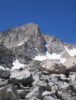
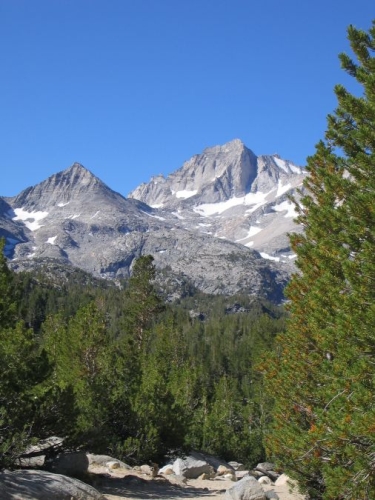
Bear Creek Spire is one of many granite peaks in the High Sierra. It is not one
of the highest, and from the west it does not even look very remarkable, but
on its northeast side it has the striking 800-foot N Arete that rises steeply
from the snow-covered talus fields, and the gentler, but equally prominent,
NE Ridge. These amazing lines, combined with an easy approach,
make the mountain a very worthwhile objective. The technical parts are all above
13,000', so some acclimatization is a good idea.
Routes:
North Arete (III, 5.8)
|
|
|
| References: Chris McNamara,
supertopo.com
|
||
Date: August 16, 2014
Party: Paul and Dietrich Belitz
Route: NE Ridge
Equipment: 60m half rope, light rack
Time: Mosquito Flats - Saddle 4 1/2 hrs
![]() Mosquito Flat - Summit 7 hr 50 mins
Mosquito Flat - Summit 7 hr 50 mins
![]() Summit - Mosquito Flats 4 hrs 20 mins
Summit - Mosquito Flats 4 hrs 20 mins
![]() Round Trip from Mosquito Flats 12 hrs 4 mins
Round Trip from Mosquito Flats 12 hrs 4 mins
Trip report:
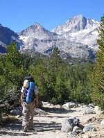
We had some unfinished business on BCS: Seven years earlier we had been unable to find the summit after climbing the N Arete. Accordingly, we returned to find the true summit, this time via the NE Ridge. We were well acclimatized and in good shape after almost a week at Tuolomne, and thus decided on a car-to-car trip. This meant we did not have to worry about a permit or a bear canister, which greatly simplified the logistics. Unfortunately, it also meant we could not legally use the campground at Mosquito Flats and had to drive back down quite a way to find a camp site. Still, it was a short drive the next morning, and our light packs (no overnight year, and only a half rope and a light rack) made for a quick hike to Gem Lakes. We skirted Point 11,645 on the right, traversing above Treasure Lakes, which is longer but less tedious than the talus on the other side, filtered water at Dade Lake, and moved on to the saddle that marks the start of the NE Ridge.
We soloed for a while, then roped up and simulclimbed over some impressive flakes. The route is MUCH easier than the N Arete, probably not even 5.5 except for a few moves here and there. As we approached the summit ridge we veered left and finally gained the ridge past the section that we remembered as tricky with respect to route finding from our earlier ascent. Another 100' of scrambling along the ridge brought us to the base of the famous summit block. Paul stuck a (useless) 0.5 Camalot in a very shallow crack for psychological protection, straddled the summit for the obligatory photo, and then it was my turn. Finally we were on the true summit of this thing! To start the descent we rappelled down to some sandy ledges that we recognized as our high point seven years ago. One can indeed not see the summit from there, but if we had gone straight up we would not have been able to miss it. Now we know.
We had lunch, went down the scree to the notch that gives access to the descent couloir, and made our way down the awful dirty third or fourth class section that was much more unpleasant than we remembered. It seemed like an eternity until we reached Dade Lake. For a change we went along the south side of Point 11,645, which involved a lot of talus that we did remember. At Gem Lakes we picked up the trail, and the rest was an easy hike back to Paul's car. We made it car to car in a bit under 13 hours, which was about what we had expected. It was a nice and easy climb that unfortunately marked the end of our vacation; the next morning Paul drove south and I drove north.
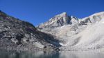
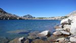
Bear Creek Spire above Dade Lake. |
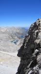
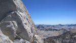
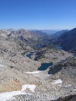
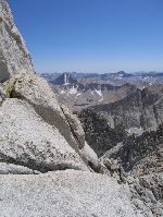
View of Little Lakes Valley from the ridge. |
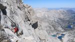
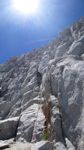
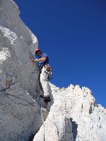
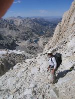
Paul on the middle section of the ridge. |
Moving from the ridge onto the face. |
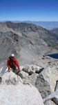
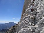
Near the summit ridge. |
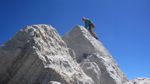
Dietrich on the true summit. |
||||||
View from the base of the summit block. |
Back at Dade Lake. |
Date: July 21-22, 2007
Party: Paul and Dietrich Belitz
Route: N Arete
Equipment: 2 sets of stoppers, Camalots 0.5 - 3, 2 small tri-cams, 15 slings
Time: Mosquito Flats - Dade Lake 3 hrs
![]() Dade Lake - Base of Arete 1 hr 15 mins
Dade Lake - Base of Arete 1 hr 15 mins
![]() Base of Arete - somewhere near the summit 7 hrs 15 mins
Base of Arete - somewhere near the summit 7 hrs 15 mins
![]() Somewhere near the Summit - Dade Lake 2 hrs
Somewhere near the Summit - Dade Lake 2 hrs
![]() Dade Lake - Summit - Mosquito Flats 16 hrs
Dade Lake - Summit - Mosquito Flats 16 hrs
Trip report:
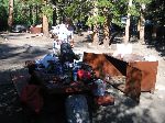
We drove up from San Diego on Friday, picking up our permit and the unwieldy bear canister in Lone Pine on the way. After overshooting the Tom's Place exit we drove up to Mosquito Flats, where Paul discovered that he had forgotten to bring his ski poles. So, no Betalight on this trip, but the weather looked very stable and we were not concerned about the prospect of having no tent. We did, however, find a $18 camping fee stiff, given that we literally just flopped down in the dirt next to Paul's car.
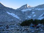
We slept quite well, despite the 10,200' elevation. The next day was meant as an acclimatization day, so it was 9am by the time we started out on the sandy trail up the Little Lakes Valley. Bear Creek Spire, and its North Arete, is visible almost all the way along the trail. An hour and fortyfive minutes got us to Gem Lakes, where the talus hopping starts, and a bit over an hour later we arrived at Dade Lake, elevation 11,600'. We spent the rest of the day lounging in the sun, taking in the view of the mountain, and eventually sorting out our gear. Late in the afternoon we talked to a party of two coming down, who reported a lot of trouble hauling their packs on the route, which prompted us to plan on climbing with only one pack (a mistake, as it turned out, but not a huge one). That night I did not sleep all that well, probably due to the elevation, but only once did I wake up sufficiently to consciously take in the amazing view of the Milky Way.
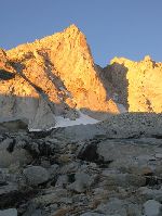
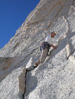
I woke up at 4:45am in the twilight of dawn, and by 5:15 we were on our way. As we worked our way up the talus slopes the sun hit the mountain, and by the time we reached the unavoidable snow field that leads up to the start of the climb the sun had softened the snow a little bit. We cached my summit pack, put everything in Paul's larger multi-purpose pack, and climbed the snow to the base of the arete. Here we switched to rock shoes, stuffed two huge pairs of sneakers into the pack on top of everything else, built an anchor, and Paul started up the first 5.7 pitch. I was somewhat winded, but otherwise felt good, but the pack almost killed me while following. The climbing was steep and surprisingly strenuous, which intimidated me enough to not want to lead the second pitch either. This turned out to be a bit easier than the first one, though, and after that I led pitches 3 and 4, the first one starting out with a cool exposed move around a corner. At the top of pitch 4 it was not obvious where to belay, and I built an anchor a bit too low and too far to the right as it turned out. To get to the start of the 5.8 pitch, Paul had to do an ascending traverse, which caused the rope to get caught under not just one, but two granite flakes. The lower one I managed to flip it out of, but the upper one was hopeless, and Paul had to downclimb to get the rope unstuck. After that the pitch went smoothly, and I followed, struggling with the heavy pack. I did not think the pitch was harder than the first 5.7 pitch (or rather, the first 5.7 pitch was not any easier than the crux pitch), but it was every bit as physical.
I led the next pitch, which involves squeezing through a keyhole and traversing on the east side of the ridge. Paul had an interesting time getting the pack through the keyhole, it was too bad I did not have the camera. After this we got confused. The topo said there should be only one more pitch before we gained the more or less horizontal summit ridge, but it took us two. We wandered around on the ridge, and finally got to a point where we could see the descent route on the west side. The location of the true summit was entirely unobvious to us. We soloed up some cracks to regain the ridge, determined that this was not the true summit, belayed back down, and pondered our options. Obviously, the true summit was still farther along the ridge, but we were not sure how far. It was getting late, we were tired, we had done the route, and we had been within a few feet of the elevation of the true summit. So we decided to skip the summit and started the descent. Steep scree in between third-class steps brought us to gentler ground and the obvious notch that leads back to the east side. Some more third class got us down to the snow fields, which were barely negotiable in sneakers, using rocks as substitutes for ice axes. We picked up the cached pack and hopped the boulders down to Dade Lake, where I took a nap.
We were unsure whether to spend the night at Dade Lake or pack down, but the prospect of better sleep at lower elevation persuaded us to keep going. The talus seemed to never end, but finally we reached the trail at Gem Lakes. An hour and twenty minutes later we arrived at Paul's car in the light of our head lamps, almost exactly 16 hours after we left our bivy.
In retrospect it is too bad that we did not go to the true summit, but we did the route, and it was a great trip. Most importantly, our acclimatization strategy worked: we were both in good shape and even ate at 13,700'. I should go back some day, maybe on an easier route, and go to the summit!
Paul sorting gear at Mosquito Flats. |
Paul on the trail. |
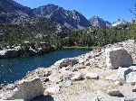
One of the many lakes on the way. |
Paul at Gem Lakes. |
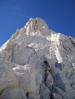
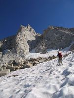
Bear Creek Spire rises above the talus. |
Our bivy near Dade Lake. |
||||||
Bear Creek Spire catches the first morning light. |
Paul starts out on the first pitch. |
View down Little Lakes Valley. |
Dietrich starts the third pitch. |
Dietrich on the third pitch. |
Paul at a belay stance. Mt. Tom in background. |
||||||
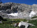
View from near the summit. |
Paul starting the descent. |
Dietrich descending the snow fields. |