|
References: N.A. Dodge, A Climbing Guide to Oregon , Touchstone Press (Beaverton, OR 1975)
| Diamond Peak is a highly eroded volcano just south of Highway 58. In summer it's an off-trail hike on scree slopes; in winter or spring it provides a nice ski trip. |
|
|
| Topo Map | ||
| Routes:
S Slopes (I, 2nd class or easy snow climb, moderate ski descent)
References: N.A. Dodge, A Climbing Guide to Oregon , Touchstone Press (Beaverton, OR 1975) |
||
Date: May 5, 2018
Party: DB solo
Route: SW Ridge of S Summit (up), SW Bowl (down)
Equipment: AT skis
Time: W Side Trailhead - Summit 4 hrs 45 mins
![]() Summit - Trailhead 2 hrs 20 mins
Summit - Trailhead 2 hrs 20 mins
![]() Roundtrip from Trailhead 8 hrs
Roundtrip from Trailhead 8 hrs
Comments: Snowline at 5,600', reasonable skinning conditions from there on
Trip report: The forecast called for showers and thunderstorms in the afternoon, so I got an early start. However, the weather turned out to be better than forecast, and there were even some sun breaks. 2018 is another bad snow year, but the snow pack, while not impressive, was not quite as abysmal as I expected. I bootpacked on the trail to the snowline at 5,600', and from there I skinned straight up the SW Ridge of the S Summit, arriving at the latter after just a bit over 4 hours. After a break I traversed over to the main summit, and then skied the SW Bowl. That was fine, except that I triggered more and bigger slides than I was comfortable with. There were a few inches of wet snow on top of some kind of a crust, and the wet stuff sloughed off like crazy. Fortunately, the crust held, but at some point about a third of the surface area of the bowl was in motion, and I decided to get out of there in a hurry. Once out of the slide zone I cooked lunch, survival-skied to the snow line, and then bushwhacked down the at times rather steep terrain, climbing over more downed trees than I could count. To my amazement I intersected the road exactly at the location of my car.
Date: June 3, 2017
Party: DB solo
Route: N Face of NW summit
Equipment: AT skis, crampons, whippets
Time: Corrigan Lake Trailhead - Summit 5 hrs 55 mins
![]() Summit - Trailhead 2 hrs
Summit - Trailhead 2 hrs
![]() Roundtrip from Trailhead 8 hrs 40 mins
Roundtrip from Trailhead 8 hrs 40 mins
Comments: I climbed the NW Summit via its N Face, continued to the main summit, and skied the bowl
Trip report:
Date: May 29, 2016
Party: DB solo
Route: NW summit via the N ridge
Equipment: AT skis
Time: Corrigan Lake Trailhead - NW Summit 5 hrs 15 mins
![]() NW Summit - Trailhead 2 hrs 45 mins
NW Summit - Trailhead 2 hrs 45 mins
![]() Roundtrip from Trailhead 9 hrs
Roundtrip from Trailhead 9 hrs
Comments: Bad conditions: Slush on a hard crust, and a killer cornice over the bowl
Trip report: For the first time in several years we had a decent snow pack. Unfortunately, two weeks of cold and wet weather had produce conditions that were worse than I anticipated, which made for slow going and ultimately made me decide to not go to the main summit.
The trail to Corrigan Lake was barricaded by an amazing number of downed trees, which was the first thing to slow me down. I contemplated just giving up on the trail, but off trail it didn't look any better, so I stuck with it. I started skinning at around 6,200', and it took me three hours to reach the saddle below the NW Peak. The NE Ridge of the NW Peak looked very bare at its lower end, so I aimed for the lowest spot where the ridge was still snow covered, hoping to still get down into the bowl from there, or a bit higher. That would have worked, but the bowl was overhung by two huge cornices on the ridge connecting the NW Peak with the main summit that were already partially detached; it was entirely unclear what still held them in place. That, plus a lot of recent rock fall from just below the main summit, made the bowl a very unpalatable proposition, and I decided to go up the ridge to the NW summit instead. After crossing a knife-edge stretch I encountered the same bad snow conditions I had already noticed earlier, only worse: slush on a very hard crust bordering on ice in places. I had to do very serious step kicking, and was glad I had my whippets. It took an eternity, and a lot of energy, to reach the NW summit. It was 2:15 by the time I got there, and I figured that given the time and the poor snow conditions I should skip the main summit. Still, it was nice up there, if cold.
I was worried that the slush would slough off if provoked, especially since much lower on the ascent I had started sliding uncontrollably while traversing a 25 degree slope on skins and had to self-arrest. So I downclimbed the first 200 vertical feet and then switched to skis. The skiing was good, and it probably would have been just fine even off of the summit, but on these solo trips I'm always very conservative. In the saddle I stopped for an extended lunch break; then I started back down into the forest. The skiing through the trees was surprisingly good, probably due to the same cool weather that had produced the nasty conditions higher up. After fighting the downed trees and the mosquitoes again I got back to my car after a little bit over 9 hours total.
Date: May 3, 2015
Party: DB solo
Route: N side via the bowl
Equipment: AT skis
Time: Corrigan Lake Trailhead - Summit 4 hrs 55 mins
![]() Summit - Trailhead 2 hrs 40 mins
Summit - Trailhead 2 hrs 40 mins
![]() Roundtrip from Trailhead 8 hrs 15 mins
Roundtrip from Trailhead 8 hrs 15 mins
Comments: The skiing wasn't bad for the worst snow year on record.
Trip report: The snow pack in 2015 was the worst on record (10% of normal in the Willamette Basin), but that is a bit misleading: The snow pack is measured at low elevation, where there was indeed hardly any snow, but a few big storms resulted in a decent, if still anemic, snow pack at high elevations.
I followed the trail to Corrigan Lake, and from there to the junction at 5,800', where there still was no snow. The snow line was at 6,500', which is indeed ridiculous for May 3. I started skinning at about 7,000'. Conditions were very icy, so I figured the traverse below the NW Summit might not be a good idea and decided to gain the NE Ridge of the NW Summit rather low. From there I dropped into the bowl and skinned straight up. The slopes of the NW Summit were covered with avalanche debris, and the cornices were actively dropping ice, so that had been the right decision. I finally gained the NW Ridge of the main summit 100' vertical below the top and cached my skis, as the ridge was bare rock and not skiable. It was warm, and even on the summit I wore only an ultralight wind shell over my t-shirt.
The skiing was remarkably good. Things had softened up by the time I started down at 2:30, and I found good corn all the way to the saddle at 7,300'. I managed to ski down to about 6,700', then bushwhacked and intersected the countouring trail 100 linear feet from its junction with the Corrigan Lake Trail. 40 minutes later I was back at my car. Very nice ski trip for the worst snow year on record!
Date: July 2, 2014
Party: DB solo
Route: NW Summit (Point 8,306) via the N Ridge, partial ski descent
Equipment: AT skis
Time: Corrigan Lake Trailhead - N Summit 4 hrs 20 mins
![]() N Summit - Trailhead 2 hrs 45 mins
N Summit - Trailhead 2 hrs 45 mins
![]() Roundtrip from Trailhead 7 hrs 35 mins
Roundtrip from Trailhead 7 hrs 35 mins
Comments: What snow was left was rather suncupped.
Trip report: I wanted to do one last ski trip this season and chose Diamond Pk because of the northern exposure. On the drive it started raining in Oakridge, and there was rain, thunder, and lightning until about 10 minutes before I reached the trailhead, at which point it stopped. The forecast called for improving weather during the day, so I got going. I found patchy snow starting at about 6,000', and more or less contiguous snow starting at about 7,000'. The lower parts of the moraine ridges were snow free, so I aimed for a rather high point on the N Ridge of the NW Summit. Once I got there I realized that I was too high to traverse the bowl, so I decided to go to the NW Summit. This was just as well, since I had never been there. I bootpacked all the way to the top, switching from sneakers to boots when I hit snow.
The true summit would have been a somewhat tedious affair involving elevation loss across a bare lava ridge, and the t-storms were rebuilding themselves, so I called it quits on the N Summit. I downclimbed the first 250 or so vertical feet (thank BD for whippets!), one because I'm a wuz, and two because I still don't completely trust my new bindings that had prereleased on me a few weeks earlier. The setting seems to be okay now, but the N Ridge of the NW Summit is surprisingly steep at the top (45 degrees) and dangerously exposed, so I didn't want to take chances. After that it was a nice but short ski descent on increasingly suncupped snow until I switched back to hiking around 7,200'. I managed to actually hit Corrigan Lake on the way down, where I picked up the trail.
Nice trip, but next season I should spend a day lift skiing at Bachelor to regain confidence in my bindings.
Date: May 12, 2012
Party: DB solo
Route: NW Ridge/N Bowl, skis
Equipment: AT skis
Time: Pioneer Gulch Road at ~4,700' - Summit 4 hrs 15 mins
![]() Summit - Pioneer Gulch Road at ~4,700' 1 hr 45 mins
Summit - Pioneer Gulch Road at ~4,700' 1 hr 45 mins
![]() Roundtrip from Trailhead 7 hrs 15 mins
Roundtrip from Trailhead 7 hrs 15 mins
Comments: Snow line was at 5,000'. Very good conditions.
Trip report: After another cold and wet spring the weather suddenly stabilized, and I decided to finally check out the north side of Diamond Peak, approaching via Corrigan Lake. I was able to drive to about 4,700', where a snow bank blocked the road. The snow line proper was just below the Corrigan Lake Trailhead, at about 5,000', and a 20-minute hike got me there.
I started out in sneakers, carrying my skis and boots, and switched to skinning at 5,500'. I must have passed close to the lake, but I did not see it either on my way up or on my way down (I was to skier's right of it). Skinning conditions were good, and I reached treeline at about 7,200' surprisingly fast. I traversed the gentle lower slopes of Point 8,306, and crested its north ridge at about 7,800'. From there I climbed the ridge for a few hundred vertical feet, and then traversed into the saddle between the main summit and Point 8,306. Impressive cornices on the ridge above me clearly were in the business of regularly sending stuff down, so I did not linger longer than necessary in the debris zone. However, none of these blocks of snow and ice had set of slides, and so I figured I would not either. From the saddle I skinned to the main summit via the NW Ridge.
It was a gorgeous day, and on the summit I recognized a few familiar voices (it was difficult to recognized people by sight because of the severe sun protection measures that were necessary), so I was not the only one who had taken advantage of the good weather. After a leisurely lunch break I skied down the NW Ridge for a little bit, and then cut right to gain the North Bowl. The next 1,200 vertical feet were spectacular! Unfortunately, I had to start traversing at some point in order to not miss the access point to the Corrigan Lake drainage. The skiing was still pretty good even in the forest, only below 6,000' it started to deteriorate. I managed to ski to 5,300', then carried my skis down to the road and finished via a long glide followed by a short walk back to my car.
It was a spectacularly nice trip; the best I had in quite a while. Also, the north side is more impressive, and offers a much more alpine feeling and much better views on the way up than the SW Ridge, while the skiing is about the same in terms of quality and difficulty. I can't believe I had never done this route before!
Main summit (right) and Point 8,306 (left) from near Corrigan Lake. |
View north on Mt. Jefferson and Mt. Hood from treeline. |
Point 8,306 from the north. |
The main summit from the NE Ridge of the NW Summit (Point 8,306). |
View north (Three Sisters, Mt. Hood, Mt. Jefferson) from the North Ridge of Point 8,306. |
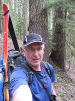
Me on the summit. |
||||||
View north from the summit. |
View of Point 8,306 from the main summit. Note my traversing skin tracks. |
My tracks in the North Bowl. |
View of Point 8,306 during the descent. |
The end of the snow. |
Date: May 20, 2011
Party: DB solo
Route: SW Ridge/SW Bowl, skis
Equipment: AT skis
Time: Pioneer Gulch Road at ~4,300' - Summit 5 hrs 10 mins
![]() Summit - Pioneer Gulch Road at ~4,300' 2 hrs 10 mins
Summit - Pioneer Gulch Road at ~4,300' 2 hrs 10 mins
![]() Roundtrip from Trailhead 8 hrs 15 mins
Roundtrip from Trailhead 8 hrs 15 mins
Comments: Very low snow line due to a severe La Niña
Trip report: The weather was even worse than the previous spring, but May 19 and 20 were a rare exception. I caught the tail end of that brief window. My idea had been to check out the north side of the mountain via Corrigan Lake, but when I ran into an icy snow bank at 4,300' I changed my mind in favor of the west side, as hiking or skinning up an icy road for quite a distance in the wrong direction didn't seem right.
This made the trip pretty much a repeat of last year's. One notable difference was that the snow in the bowl was really good; not quite corn, but getting there. This made for extremely good skiing for the first 2,500' vertical or so; then came the usual survival skiing through the woods on marginal snow.
Nice trip, but next year I'll have to try the north side!
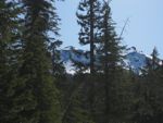
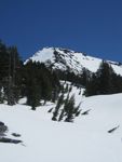
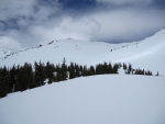
Diamond Peak above the flat area at ~5,500'. |
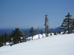
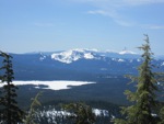
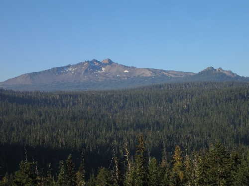
Sawtooth Mountain above Summit Lake as seen on the ascent. |
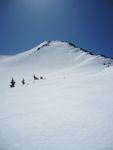
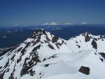
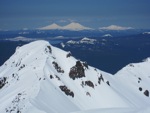
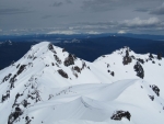
View of the main summit from the south summit. |
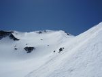
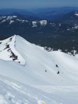
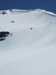
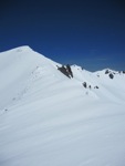
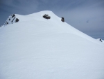
The corniced summit ridge. |
View north from the summit: The Three Sisters above the north summit. |
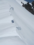
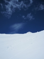
My tracks in the bowl. |
Date: May 30, 2010
Party: DB solo
Route: SW Ridge/SW Bowl, ski descent
Equipment: AT skis
Time: Pioneer Gulch Trailhead - Summit 4 hrs 35 mins
![]() Summit - Trailhead 1 hr 50 mins
Summit - Trailhead 1 hr 50 mins
![]() Roundtrip from Trailhead 7 hrs 20 mins
Roundtrip from Trailhead 7 hrs 20 mins
Comments: Less than ideal conditions
Trip report: The weather had been miserable all spring, and I caught a brief break over Memorial Day Weekend. I left the Pioneer Gulch trailhead at 8am and gained almost 1,000' of elevation before hitting the snow line at around 5,500'. I switched from sneakers to boots and made very slow progress postholing for the next half an hour. It was obvious that it had been snowing a lot lately on not much of a base. As soon as there was enough snow cover I switched to skins, which worked much better, and skinned up the ridge to the false summit and on to the true summit. The snow pack looked decent for late May; the lousy spring helped some after a very dry winter. A large party was skiing the North Bowl, and two of them had come up to the summit, but otherwise I was by myself.
I dropped into the bowl directly from the summit. The snow was decent for a while, but turned too soft pretty soon. I did not help that it was the first reasonably warm day in quite a while. Still, the skiing was fun. I traversed back to the south side of the ridge at around 6,000' and managed to not only ski to the true snow line at 5,500', but also to actually hit the trail at that point. Half an hour later I was back at the car, just as it started to drizzle; I had caught the weather window perfectly.
The flats around 6,000'. |
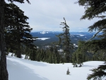
View South from the lower part of the ridge. |
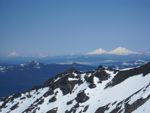
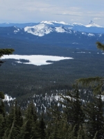
Sawtooth Mt. across Summit Lake. Mt. Thielsen in the background. |
Approaching the true summit. |
View North from the summit. |
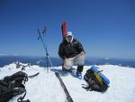
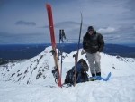
On the summit. |
||||||
View NW from the summit. |
View back to the summit from the bowl. |
The bowl from the lower part of the ridge. |
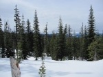
Back in the forest. |
For earlier ascents, click here .