|
References: Don Reid,
Yosemite's Select , Chockstone Press (Helena, MT 1998)
![]() supertopo.com
supertopo.com
| Half Dome hardly requires an introduction, it is one of the most universally recognized mountains in the world. While not particularly high, it rises almost 5,000 vertical feet from the valley floor and is visible from many popular viewpoints in Yosemite National Park. The cables route on the east side provides a nontechnical way to the summit, making it a popular hiking destination. The technical routes are of big-wall caliber, except for Snake Dike on the SW Face, an amazing route that follows a natural feature and can easily be climbed in a day. Originally done with minimal pro by Beck, Bridwell and Fredericks in 1965, the route was retrobolted (at the request of the first ascensionists) by Steve Roper and John Gibbons on the second ascent, and the bolts have since been upgraded to modern standards. Still, the R rating should be taken very seriously; a lead fall on any of the 100-plus-foot runouts would likely have dire consequences. |
|
|
| Topo Map | ||
| Routes:
Snake Dike (II, 5.7R)
References: Don Reid,
Yosemite's Select , Chockstone Press (Helena, MT 1998)
|
||
Date: August 28, 2005
Party: Dietrich and Paul Belitz
Route: Snake Dike
Equipment: double set of stoppers, Camalots #0.3 - #3
Beta: On the first pitch, go straight for the left side of the overlap (where you want to go); going up right first to set pro, as many books suggest, is not very productive and likely to lead you into 5.10 plus friction territory. On the second pitch, don't miss the traverse right at the start (not likely, as going straight up does not look inviting). On the higher pitches, don't get suckerered into taking deadend dikes; check the topo occasionally.
Time: Trailhead - Base of Route: 3 hrs 30 mins
![]() Route proper: 4 hrs
Route proper: 4 hrs
![]() Base of Route - Summit: 5 hrs 10 mins
Base of Route - Summit: 5 hrs 10 mins
![]() Roundtrip from Trailhead: 13 hrs
Roundtrip from Trailhead: 13 hrs
Comments: Take fewer stoppers and more cams (to #2 Camalot)
Paul and I started around 3:15am from our camp at Porcupine Flats and drove to the Valley. The original idea had been for Monique to start hiking at the same time and meet us on the summit of Half Dome, but she changed her mind at the last minute, stayed in her sleeping bag, and hiked North Dome later that day. The drive took forever, and it was 5am until we finally got going on the trail towards Vernal Falls. Near the top of the falls it got light, and after a brief breakfast stop we continued past Nevada Falls and around Liberty Cap to Lost Lake. Here we passed another party, who had gotten a much earlier start, and started up the well-cairned slabs. They start out with some bushwhacking (the Manzanita is surprisingly sharp), then turn to more open third class, and finally to fourth class that was kind of the limit of what I was comfortable doing in sneakers. The fourth class brings one to the broad ridge that leads up to the base of the climb.
I started out on the first pitch, following the advice given in the books, namely, to first go up right and set pro. What a mistake! I got some pro in alright, but when I tried to traverse after going back down ten or so feet I found myself in 5.10a friction land. This I would have handled, but as I kept traversing it got even harder, and I decided to back off. Then I went way down, traversed lower, and did what I should have done in the first place: Go straight for the left side of the prominent overlap. Once there I got in a #10 stopper and breathed a sigh of relief. Paul was concerned about rope drag, on account of the pro far to the right, but I knew the stopper would self clean once I was above it. Indeed, ten feet higher I got in a cam, yanked on the rope, and out came the stopper. The remainder of the first pitch was very cool crack climbing to the top of a prominent flake. The belay anchors are actually a bit high, Paul had to simul the slab for ten or fifteen feet. I did not even notice this, which led to some confusion once I got off belay. After sorting this out, Paul came up and prepared to lead the second pitch.
The second pitch is a bit tricky, as one needs to traverse way right (no pro, of course) to find a weak spot in the overlap. After some friction Paul got in a cam, found the bolt above the overlap, missed the one that's supposed to protect the second 5.7 friction crux, and got to the belay on the dike. Now the 5.4R stuff started. I found a bolt a few feet above the belay, then nothing for a LONG time, then some ancient anchor bolts that I passed, again nothing for a long time, and finally I got to a nice anchor almost a full 200' up.
I had not felt all that great on the third pitch, and that got worse while following the fourth (more 5.4R). I felt weak, and my achilles were killing me, which is very unusual for me. So I ate a power bar, drank something, took off my shoes, and asked Paul to lead the fifth pitch as well. He did, I recovered, and from the sixth pitch on we swung leads again. The climbing is amazing, with quartz jugs all over the dike that sticks out of an otherwise very smooth face. It's easy enough, but the 100-foot runouts keep you on your toes. The views are pretty cool, too. Finally we got to the point where the dike gives way to some lower-angled broken stuff where the route is not all that obvious anymore. I belayed below what looked like one final buttress, and once we got above that we declared it third class and unroped.
At this point it became painfully obvious what we had known more or less for quite a while: We did not carry enough water. (I had suspected that early on, which is why I drank little on the approach, which probably contributed to my not feeling so great on pitch 4.) To make things worse, Monique had the filter, and since she was not to meet us after all this meant we would not get any water until we reached the fountain below Vernal Falls, just a mile from the trailhead. So we budgeted the water and hiked up the never-ending slabs, first third class, then second class. Eventually we saw some tourists, and pretty soon we reached the double-humped summit.
The cables route proved steeper than we had expected, and we wondered how often one tourist falling high up takes out the entire cable population. (Can't happen too often, or the NPS would long have gotten sued into closing the route.) Then came the endless dusty trail in the wrong direction, followed by the endless sandy trail along the Merced River. The forest is nice, and so are the views, but we were getting seriously thirsty at this point. When we finally reached the fountain we drank tremendous amounts, then we ran down the final mile and hiked back along the road to our car.
Extremely impressive route! It may deserve more than the honorable mention it got in 50 Classic Climbs.
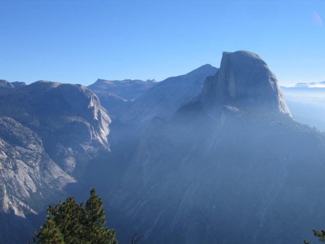
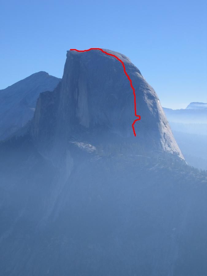
The SW Face of Half Dome as seen from Glacier Point. The approximate route can be seen here . |
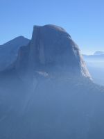
The S Face of Half Dome early in the morning from Lost Lake ... |
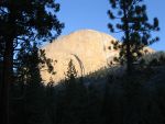
... and from the fourth class slabs higher up (some dikes are visible now). |
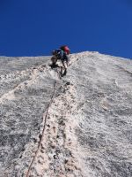
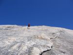
Dietrich wrestling the snake (pitch 3). |
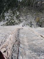
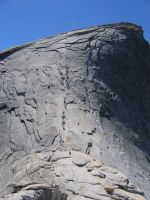
Looking down the dike to the start of the route. |
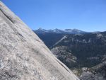
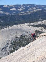
View of the High Sierra from high on the dike. |
||||||
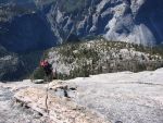
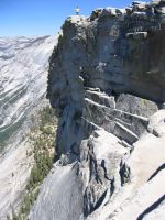
View of the valley towards the end of the technical part. |
What followed were third-class slabs ... |
... and some more third-class slabs ... |
... until we got to the summit ... |
... and descended the cables. |