Routes: South Side (Grade I, Class 2, moderate ski descent)
|
|
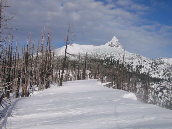
The high point in the South Ridge of Three-Fingered Jack is a nice off-trail
hike in the summer, and a popular ski destination in winter.
Routes: South Side (Grade I, Class 2, moderate ski descent) |
|
|
| References: Jeff Thomas, Oregon High Keep Climbing Press (Portland, OR 1991) | ||
Date: February 7, 2016
Party: DB solo
Time: 4 hrs 20 mins from Santiam Pass to Summit ridge; 2 hrs 15 mins from summit to pass, 7 hrs 30 mins roundtrip
Comments: Great weather, bad snow. Many misleading skin tracks.
Trip report:
Finally we have an average snow pack this winter; about 3 feet at Santiam Pass. The weather was great, and lots of people were out, including at least 15 total who went to the ski summit. Unfortunately, there were myriad skin tracks, too. Some of them went in very weird directions, and some went too high on the ridge. Breaking trail was hard on account of the bad snow (it had warmed up recently). That combination cost me quite some time both on the way up - it took me two and a half hours from the Sno Park to the traverse - and also on the way down. It was a nice trip, but winter snow in the Oregon Cascades just sucks!
Party: Dietrich Belitz solo
Time: 3 hrs 50 mins from Santiam Pass to Summit ridge; 2 hrs from summit to pass, 6 hrs roundtrip
Comments: Little snow, no trail
Trip report:
There was very little snow, and I barely managed to skin from the pass and ski back to it. The summit ridge was drifting in and out of the clouds, and I reached it in a whiteout. When the cloud lifted for a few moments I realized it was not quite at the highest point, but I did not bother to traverse hundreds of feet to gain another 20 feet in elevation. The main summit of Jack never became visible. The snow was so-so, slightly sandy over a hard crust high, and very little snow below the ridge traverse, which forced me to follow my skin tracks back down; there was not enough snow to take an arbitrary path through the burn area. As on my last trip, the area was completely lifeless; I did not see a single living thing.
Date: January 10, 2009
Party: Dietrich Belitz solo
Time: 3 hrs 40 mins from Santiam Pass to Summit; 2 hrs 5 mins from summit to pass, 6 hrs 35mins roundtrip
Comments: Little trail breaking, some ice
Trip report:
I started from Santiam Pass Sno Park around 9:30am and followed a good skin track up the ridge. A slow-moving storm was coming, it was cold, and a strong wind was blowing. The ridge was icy, and impressively corniced. After two hours I reached the traverse above Summit Lake and mostly continued to follow the pre-existing skin tracks. This party cannot have been far ahead of me, the tracks were at the very most 24 hours old, but I never saw any trace of them, nor did I find any descent tracks. As I climbed, the views got more and more impressive, and the wind stronger and stronger, and on the summit I was immersed in formidable spin-drift blizzard. There was a sustained wind of at least 25mph, with higher gusts. I dug a small trench, got the stove going on the third attempt, made some lunch, and enjoyed the view. The snow was not ideal for skiing; it somehow was both sandy and heavy, turning was hard, and my skis tended to catch at the end of each turn. It did not help that I had neglected to put some fresh wax on. After the traverse I put my skins back on until I reached the meadows, and then had an enjoyable glide back to the sno park. I did not meet a soul on the entire trip, not even a bird.