Routes:
North Arete (II, 5.7)
|
|
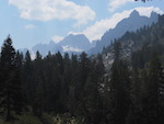
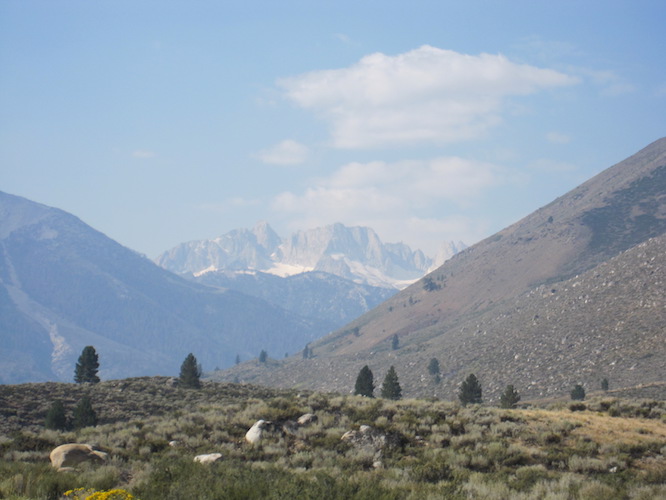
Matterhorn is the highest summit in the Sawtooth Range and is clearly visible
from Highway 395 near Bridgeport. Other than the rotten rock (on the lower
parts) it does not have much in common with its famous namesake in the Swiss
alps. The best known technical route is the North Arete, which provides a
nice alpine experience: A long approach with a camp at an alpine lake, some
easy snow climbing, and moderate rock that keeps improving as one gets higher.
Routes:
North Arete (II, 5.7)
|
|
|
| References: Chris McNamara, supertopo.com | ||
Date: August 31 - September 1, 2017
Party: Paul and Dietrich Belitz
Route: North Arete
Equipment: Alpine rack to #5 Camalot, crampons, whippets/light ice axe
Time: Twin Lakes - bivy at 9,800' 4 hrs 15 mins
![]() Bivy - Base of Route 3 hrs
Bivy - Base of Route 3 hrs
![]() Time on Route 5 hrs
Time on Route 5 hrs
![]() Summit - Bivy 2 hrs
Summit - Bivy 2 hrs
![]() Bivy - Twin Lakes 3 hrs
Bivy - Twin Lakes 3 hrs
Trip report:
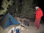
After abandoning plans for Matterhorn the year before due to a bad heel on my part we tried again. We packed up from Twin Lakes carrying as little as we considered reasonable, but the ropes, the combined rock and snow equipment, and the bear canister still made for formidable packs. The first two miles are on a very good trail, then the going gets rougher, and gaining the saddle requires some talus travel, but it's all in very nice scenery. After a bit over 4 hours we reached the small lake at 9,800' where we pitched the Betalite.
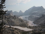
The next morning we got an alpine start, soon hit surprisingly hard snow, and put on our ancient SMC crampons. A few hundred vertical feet of easy snow brought us to the moraine of what passes for a glacier in California, which we hit a bit too high, crossed the flat part, and then ascended steeper snow to the base of the prow. We ditched our boots and snow climbing equipment, wallowed up the scree to the base of the route, and three hours after leaving camp we started out on the first pitch.
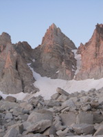
The rock on the first two pitches is pretty bad, and the route finding is a bit tricky. On the second pitch I got lured too high by both the terrain and a lot of fixed gear and had to correct by downclimbing a rotten 5.6-ish section, but soon we reached the arete. The third pitch had much better rock quality, and the fourth one, which switches from one finger crack to another, was superb. At that point we were out of the sun, and the route lived up to its cold reputation. Passing the chockstone that blocks the way to the dihedral turned out to be easier than expected; then Paul attacked the crux pitch where the large cams came handy. We belayed again on the ledge at the top of the dihedral and hauled the packs on the final section to the summit ridge, which requires squeezing into an offwidth. Then came the traverse to the true summit, which is fourth class alright, but amazingly exposed. After exactly 5 hours of climbing we found ourselves on the summit with very nice views.
The descent is easy, but there are many couloirs and one has to make sure to descend the right one. We switched back to boots, collected our gear, and made it down to the lake in two hours. I had stupidly forgotten to take sunglasses and was glad to get off of the snow. Then came the long haul back down. We realized that it had been a long day already, as our packs felt a lot heavier than on the way up. Finally we got down to Twin Lakes, though, where I added another 15 minutes to the pack hauling by getting lost in the maze of trails and missing the bridge. By the time we got back to our cars my shoulders were kind of shot, but the next morning I felt surprisingly good.
Nice trip with a very alpine feeling!
Paul at Cathedral Pass. |
The snow fields and the moraine from the bivy site. |
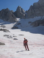
Paul warming up for the alpine start. |
View of the mountain from the moraine. |
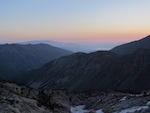
View of the valley from the moraine. |
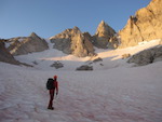
On the glacier. |
||||||
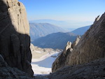
View of the valley from the base of the route. |
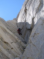
Paul starting up the dihedral. |
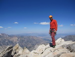
Paul on the true summit, view north. |
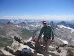
Dietrich on the true summit, view south. |
Back on the glacier. |
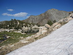
The lake at 9,800'. |