Routes: W/S Side (moderate ski descent)

|
|
Maxwell Butte is a minor summit just west of Three-Fingered Jack. In summer it is an easy trail hike, but
in winter it can be quite challenging, depending on conditions. Unfortunately, it is west of the Cascades
crest, so the snow more often than not is awful. The main reason why I go there so often is that it is a
mere hour's driving from my home.
Routes: W/S Side (moderate ski descent)
|
|
|
Party: DB solo
Route: W Side
Equipment: Crampons
Time: Sno Park - Summit: 4 hrs 20 mins
![]() Summit - Sno Park: 2 hr 20 mins
Summit - Sno Park: 2 hr 20 mins
![]() Roundtrip from Sno Park: 7 hrs
Roundtrip from Sno Park: 7 hrs
Comments: Horrible snow conditions.
Trip report:
There was not enough snow for skiing, but too much snow for hiking, so I set out from the Sno Park carrying snow shoes and crampons. The snow pack was very thin for about 2/3 of the way to Twin Lakes, and there were more downed trees than I could count. Above the lakes the snow got deeper and I put on snow shoes, only to have the straps break after a few hundred linear feet; they were just too old. I cached the snow shoes and continued post holing in horrible snow, which made for very slow going and cramping thighs. Eventually I put on crampons, but it didn't help much. The views from the summit were nice, but I had no time left, so I turned straight around and went back down, pausing only to pick up my snow shoes and make some instant noodles. The next day I replaced my snow shoe straps.
Party: DB solo
Route: S Side
Equipment: Whippets
Time: Sno Park - Summit: 2 hrs 40 mins
![]() Summit - Sno Park: 2 hr 15 mins
Summit - Sno Park: 2 hr 15 mins
![]() Roundtrip from Sno Park: 5 hrs 40 mins
Roundtrip from Sno Park: 5 hrs 40 mins
Comments: Horrible conditions: Part breakable crust, part bullet-proof ice.
Trip report:
It had been cold and dry for weeks, so I did not even bother to take skies. Indeed, the snow line was above the wilderness boundary, and the snow pack higher up was abysmal. Breakable crust alternated with hard ice, and no account of the latter I opted for the south side, which I hoped was a bit softer than the west side. To the extent that this was true, it was a relative effect: I was glad I had my whippets, and crampons (which I did not take along) would not have been ridiculously out of place. Somebody had gone to the summit after the last snow fall, which helped with the crust part, and so I made good time despite the poor conditions. The views were great.
Party: DB solo
Route: W Side
Equipment: Ski poles
Time: Sno Park - Summit: 3 hrs 10 mins
![]() Summit - Sno Park: 2 hr 10 mins
Summit - Sno Park: 2 hr 10 mins
![]() Roundtrip from Sno Park: 6 hrs 5 mins
Roundtrip from Sno Park: 6 hrs 5 mins
Comments: Trailbreaking all the way, but reasonably good crust with some postholing
Trip report:
Another strong La Nina winter made for a cold and dry fall. I figured skiing was not a great idea, but several days of fog in the valley made me want to go out. I found an extreme temperature inversion: I sat in my t-shirt at 6,200' cooking lunch while the high in Springfield was 33 degrees. Travel on foot was okay, with between zero and six inches of snow on top of a crust that mostly carried me, there were only a few patches where postholing was a problem. The views were marvelous.
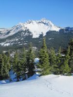
View of Three-Fingered Jack from the summit. |
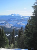
View of the Three Sisters from the summit. |
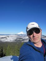
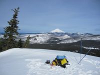
Me on the summit, Mt. Jefferson in background. |
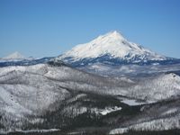
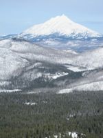
View of Mt. Jefferson and Mt. Hood from the summit. |
Party: DB solo
Route: W Side
Equipment: None
Time: Sno Park - Summit: 2 hrs 30 mins
![]() Summit - Sno Park: 1 hr 50 mins
Summit - Sno Park: 1 hr 50 mins
![]() Roundtrip from Sno Park: 4 hrs 50 mins
Roundtrip from Sno Park: 4 hrs 50 mins
Comments: Good hiking conditions
Trip report:
I found out the night before that I had left my ski boots in Portland, so I set out carrying snow shoes instead. The lack of skis turned out to be just as well; most (but not all) of the skiing would have been awful.
I got going from Maxwell Sno Park at 9:40. The snow pack was pathetic, so I left the snow shoes on my pack. It turned out I never needed them; after a little while I encountered a few inches of soft snow on top of a very hard crust that easily carried my weight, and it stayed that way all the way to the summit. I reached Twin Lakes after an hour and twenty minutes, continued on the trail for a while and then kicked steps straight up the west side. High up it was a bit marginal without crampons and ice axe in a few spots, but soon I reached the summit ridge and continued on to the summit.
I got the stove going, cooked some lunch, enjoyed the views, and then started back down. It was warm, and a storm was coming in from the west, which made for interesting colors. Except for a few steep icy sections going down was easy, and I reached my car in under two hours. The soft snow on top of the crust was very wet and heavy by now, and below the lakes there was not much snow anyway, so I didn't miss my skis too much. The lower part of the west side and the meadows would have been nice on skis, though!
Mt. Jefferson and Mt. Hood from the summit. |
Mt. Jefferson from the summit. |
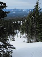
View west on the way down. |
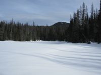
Twin Lakes. |