|
References: N.A. Dodge, A Climbing Guide to Oregon , Touchstone Press (Beaverton, OR 1975)
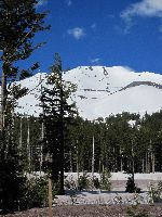
| Mt. Bachelor's historical (and proper) name is Bachelor Butte. The name change occured for PR reasons when the mountain acquired the dubious distinction of being the only summit in the Oregon Cascades that can be reached by ski lift. This limits worthwhile ascents of the cinder cone to a brief window right after Memorial Day Weekend, after the lifts close and before it all melts out. The ascent is short (only 2,700 vertical feet), the descent on the deserted slopes is fun, although hardly a wilderness experience, and the views are cool. In the summer a trail leads up from the ski area, but hardly anybody ever bothers; there are better hikes around. |
|
|
| Topo Map | ||
| Routes:
NE Ridge (I, easy snow, moderate ski descent)
References: N.A. Dodge, A Climbing Guide to Oregon , Touchstone Press (Beaverton, OR 1975) |
||
Date: June 7, 2015
Party: DB solo
Route: N Ridge (up), NE Bowl (ski descent)
Equipment: AT skis
Time: Highway - Summit 3 hrs 20 mins
![]() Summit - Highway 1hr
Summit - Highway 1hr
![]() Roundtrip from Highway 5 hrs
Roundtrip from Highway 5 hrs
Trip Report: 2014/15 had the worst snowpack on record in the PNW, but I was hellbent on getting one more skiing trip in. Since I did not have much time I chose Bachelor, which had closed down its lift operation two weeks before. When I arrived at my usual parking spot in front of one of the locked gates there was a big sign saying "Summit Closed", which went on to talk about "race camps" and "ongoing grooming", and the entire mountain being off limits. This business of public land becoming unaccessible to the public seems to be getting worse and worse. I found a different parking spot with no sign and got ready, never having seen the sign, of course. Just when I was starting out a pickup truck with the Mt Bachelor logo showed up on the dirt road, so I went back to my car and got busy sorting things in the trunk. The truck passed, and I started out for real. Half way up the mountain I heard a snow cat, so I hid in the trees for a while. Then I saw two guys on skis and was about to hail them as fellow outlaws when I realized that they were hauling a litter (empty), so I hid in the trees some more. When the air was clear I continued, taking a very northwesterly route to stay far away from the summit lift, which was running but without any people in it, and I even stayed away from the bowl where one is very visible, choosing the adjacent ridge instead. That's quite a bit longer than going straight up, and I was not in good shape either, having slept poorly the night before, and it took me forever to get to the summit.
The snow pack did indeed look abysmal, and I was glad I had not tried South Sister, where the snow line was above the flat terrain above Moraine Lake. For going down I chose the bowl, eager to check whether my tech bindings are now appropriately set for steeper stuff. They were, and I had a pretty good run, on snow that was not great but not horrible either. On the lower part I followed a dead groomed run and was able to ski to within 200 vertical feet of the highway, quite to my amazement. By absolute standards the skiing was just okay, but for the worst snow year on record it was pretty good. On the way out I ran into the pickup truck again, and the guy was very friendly, so maybe they just put the sign up to scare people off, or because their lawyers told them to.
Photo Gallery: Click the thumbnails to see a higher resolution image
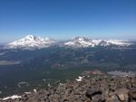
View of the Three Sisters from the summit. |
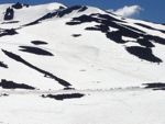
My tracks in the bowl. |
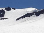
View of the North Ridge and the bowl. |
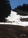
The end of the snow. |
Date: May 30, 2014
Party: DB solo
Route: NE Ridge, ski descent
Equipment: AT skis
Time: Highway - Summit 1 hr 53 mins
![]() Summit - Highway 20 mins
Summit - Highway 20 mins
![]() Roundtrip from Highway about 3 1/2 hrs
Roundtrip from Highway about 3 1/2 hrs
Comments: I started skiing the bowl, which was in good condition, but fell due to a prereleasing binding. I had no tools, so I switched to the NE ridge.
Date: June 16, 2011
Party: DB solo
Route: NE Ridge, ski descent
Equipment: AT skis
Time: Highway - Summit 2 hrs
![]() Summit - Highway 20 mins
Summit - Highway 20 mins
![]() Roundtrip from Highway 3 1/2 hrs
Roundtrip from Highway 3 1/2 hrs
Comments: Lots of snow. The bowl was not in condition (too icy).
Photo Gallery: Click the thumbnails to see a higher resolution image
Date: June 12, 2010
Party: DB solo
Route: NE Bowl, ski descent
Equipment: AT skis
Time: Highway - Summit 2 hrs 50 mins
![]() Summit - Highway 20 mins
Summit - Highway 20 mins
![]() Roundtrip from Highway 4 1/2 hrs
Roundtrip from Highway 4 1/2 hrs
Comments: Still a lot of snow. Snow good at high elevations, sticky low.
Photo Gallery: Click the thumbnails to see a higher resolution image
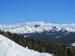
Mt. Bachelor from the ski area parking lot. |
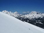
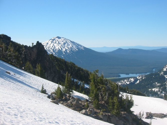
View of Broken Top during the ascent. |
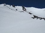
At the base of the bowl. |
View of the Three Sisters and Broken Top from near the summit. |
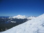
Sparks Lake, the Three Sisters, and Broken Top from the summit. |
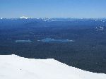
View of the Cascades Lakes and Diamond Peak from the summit. |
||||||
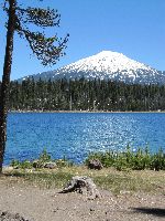
View of Mt. Bachelor across Lava Lake. |
Date: May 30, 2008
Party: DB solo
Route: NE Bowl, ski descent
Equipment: AT skis
Time: Highway - Summit 2 hrs 20 mins, roundtrip from Highway 3 1/2 hrs
Trip report: I was going to miss most of the skiing season in the first decent now year in a decade, due to a long trip to Europe, and I desperately wanted to get out one more time before I left. I did not have much time, and the weather had been bad, so I opted for Bachelor over Diamond Peak. I drove through low clouds and drizzle, but just east of Santiam Pass the weather cleared, it was sunny, and the mountains were all visible. I parked below Sunrise Lodge and bootpacked straight up the NE Bowl, which is quite steep near the top. (I measured it in 2010; the steepest section is 30 to 35 degrees.) The snow was near perfect for kicking steps, not too hard and not too soft.
While I was going up, three telemarkers came skiing down, and after a while on the summit I was joined by a guy who came skinning up the groomed slopes, but otherwise I had the mountain to myself.
I skied the line I had climbed, going from jump turns to weaving through the cinder ridges to cruising down the deserted runs back to my car. Very nice descent, but much too short! I was back down at my car by 12:30pm, and home by 3pm. Very nice trip!
For earlier ascents, click here .