I had spent the first half of the summer in Europe, where I got in a little bit
of climbing and an awful lot of work, so I was eager to finally do a big trip.
Both Paul and I were keen on doing one of the Fifty Classic Climbs. Paul had set
his sights on Stuart's North Ridge, while I was more in favor of Forbidden's West
Ridge, both because it looks really cool and because I was worried that Stuart
would be a bit much for me, out of shape as I was. What finally settled it was the
fact that it was
pretty late in the season, and the approach to the ridge on Forbidden was clearly
no longer in condition. So we picked a tentative date and I started spending my
lunch breaks doing 2,000 ft in 40 minutes on the stairmaster to get back in shape
after my city slicker time in Europe. Paul and I would try the North Ridge, and
Monique would come along for the hike and to provide some support.
The agreed-upon date arrived, and the weather forecast was so-so at best. (The weekend
before had been perfect, of course!) Still, after finishing off some work on Friday,
Monique and I packed and got
ready for the drive to Seattle. I had read too much in Mark Twight's book, and decided
to emulate the light-and-fast stuff by doing without a sleeping bag, figuring that a
belay jacket, which I wanted to take anyway, would do. We took a tent, though, to give
Monique more of a homey feeling
during the night she would likely spend by herself. The plan was that on Saturday we
would pack up to Stuart Pass; on Sunday Paul and I would do the ridge while Monique
would move our camp down into the valley; we would find her there either during the
night, or, after a bivy somewhere high on Stuart, on Monday morning; then we'd pack
out over Long's Pass, hopefully in time for Paul to make a 4pm lab meeting. During
the trip to Seattle the weather deteriorated more and more, and just after Olympia
it started to rain. I was glad we had decided in favor of a hotel in Seattle; camping
would have made us start the trip with a lot of wet gear.
When we picked up Paul early on Saturday morning it was still raining. It stopped only
after we crossed Snoqualmie Pass, and even in Cle Elum the weather still looked unsettled.
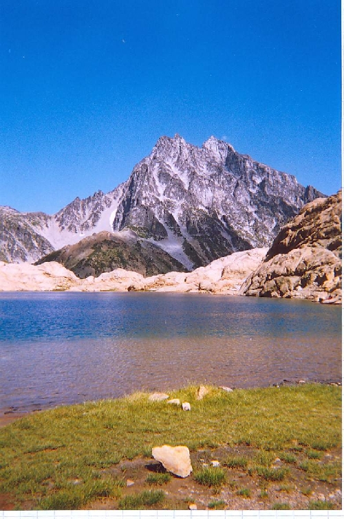
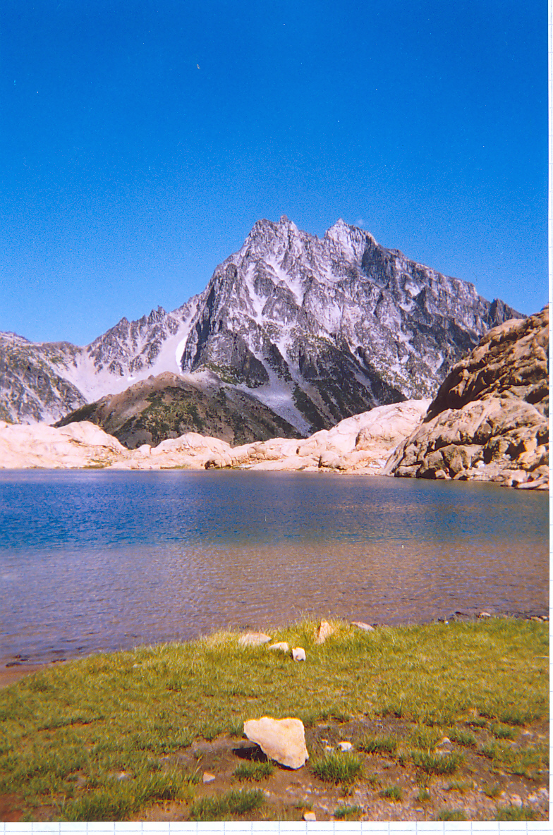
Shortly thereafter we got the first view of our mountain. The hike up to Ingalls Pass
was easy since it was not too warm, and from the pass we saw the Stuart Massif at close
range for the first time. The biggest exposed chunk of granite in the contiguous 48
states, no shit! Ingalls Lake was as impressive as we had heard it should be, but
horse flies made sure we did not linger too long. Negotiating the left bank with our
heavy packs was time consuming, and so was the traverse over to Stuart Pass, but we
got there at a pretty decent time. We set up camp, and then made two trips to the
waterfalls below Ingalls Lake. After sunset it got cold fast, and I started to wonder
whether not taking a sleeping bag had been such a great idea. Stupidly, I tried to use
my belay jacket as a blanket, which did not work all that well. I was still awake when
at 1:30am a noisy party passed our tent. At that point I finally decided to put on the
jacket, instantly got warm and fell asleep.
Two hours later the alarm went off. Paul emerged from his down bag outside, I from the
tent, we had some breakfast and did some last-minute packing. The weather did not look
great. Some stars were visible, but there were drifting clouds and a pretty strong wind
even that low (from the SE, strangely), but we decided to give it a try. After impressing on Monique
that we were more likely than not to bivouac, we started up the ridge that leads to
Stuart's West Ridge. It was pretty dark, and we cliffed out a few times, but we finally
got to the point where one needs to drop down to the talus field below Goat Pass. There
we found the party I had heard the night before. They were planning on the West Ridge,
but were in no hurry to get out of their bivy sacks, and we never found out whether
or not they had done the route. We dropped down to the talus and spent the next hour or
so boulder hopping until we got to Goat Pass. No goats anywhere. We were disappointed!
It was cold, the wind was blowing, the clouds were drifting, and the North Ridge looked
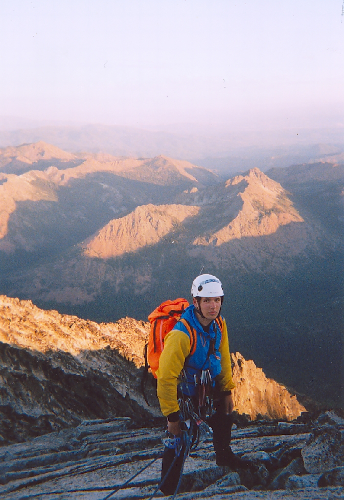
forbidding. We each ate a power bar, put SMC crampons (these things are amazing; they
stick to any footwear, although they are a pain to put on) on our sneakers waterproofed
with plastic bags, got out our ice axes, and started on the
glacier. The surface was icy, and roping up would clearly just have meant two fatalities
in case of a slip, rather than just one, so we left the rope in the pack. Halfway across
the glacier I started voicing my concerns about the weather. Paul was clearly worried that
I would turn around, forcing him to do the same, but strangely, articulating my concerns
helped clear things up in my brain, and suddenly I understood the weather pattern: Clearly,
the jet stream was going inland way south (unusual for this time of year) and then looped
back up north East of the mountains, which explained both the rain in Seattle and the
south-easterly wind where
we were at. It also meant that most of the moisture was long gone by the time the stuff
arrived here. So we should be okay; there was some cold and moderately strong wind to
be expected from the summit on down, but the ridge should be protected from the wind and
the weather was unlikely to deteriorate into a real storm. Just as my train of though
had arrived at this point the icy surface
turned into full-blown blue ice, which turned my mind from the weather to what I was
doing. We carefully crossed the blue section, then the angle eased and after a tricky moat
crossing we were on rock. About halfway up the gully I decided I was no longer comfortable
in my sneakers, so we switched to rock shoes and roped up. While we were changing shoes we
noticed a party that was rapping down to the right of the ridge. They produced a hell of
a lot of rock fall; fortunately we were high enough at the point to be out of their target
zone. I had a brief shouting
communication with them to determine why they were bailing (one of them had bonked on pitch
four or so), and shortly thereafter we were in the notch
on the ridge. Really cool bivy sites there, which is good to know in case one ever wants
to do the entire ridge.
Turning around was totally out of the question now, we were both gung-ho to go up. I led the
first pitch, and both the rock and the position were just exhilarating. It soon became obvious
that the classic route proper, about 100 feet below the ridge, is quite a bit easier, but we
stayed on the crest. The climbing started at about 5.4, but soon became sustained 5.7.
We were not comfortable simul-climbing at that grade, so we systematically swung leads.
On pitch 7 (I think)
I ran into a slightly overhanging wall that had looked doable from the start of the pitch,
but looked like at least hard 5.10 upon closer inspection. So I went back and up left instead.
Unfortunately, the only pro I could get was a big cam under the overhang, and even with the
longest sling I had this produced some unbelievable rope drag higher up. I should have
downclimbed after getting my next piece in and taken out that cam, but by the time I
realized that it was too late. At the same time
the climbing got quite hard, maybe stiff 5.8, and I realized that the sling I had just
put around a flake was too stretched out and would almost certainly break if I fell on
it. I got nervous and dropped a biner, but after an interesting balancing move to get off
the flake I found a perfect belay spot. Bringing Paul up to the cam
under the overhang was not easy; I had to pull on the rope like crazy. After an exciting
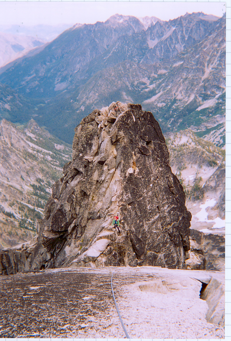
gendarme downclimb, followed by the famous slab pitch, we were getting close to the
Great Gendarme and finally wound up at the rappel station at its foot. We had done 11
pitches from the notch to this point.
We both were getting tired at that point, so we rested and ate something. The
classic fourth-class route after the rappel looked icy and not very inviting, and we had
planned on the gendarme anyway, so Paul geared up to lead it. The first pitch did not look
too bad, actually, and he just floated it except for the final mantel move. We hauled the
packs, and I followed without problems. It felt definitely easier than Moonshine Dihedral
at Smith Rock, my benchmark for trad 5.9. Hell, I could have led this with no trouble. The
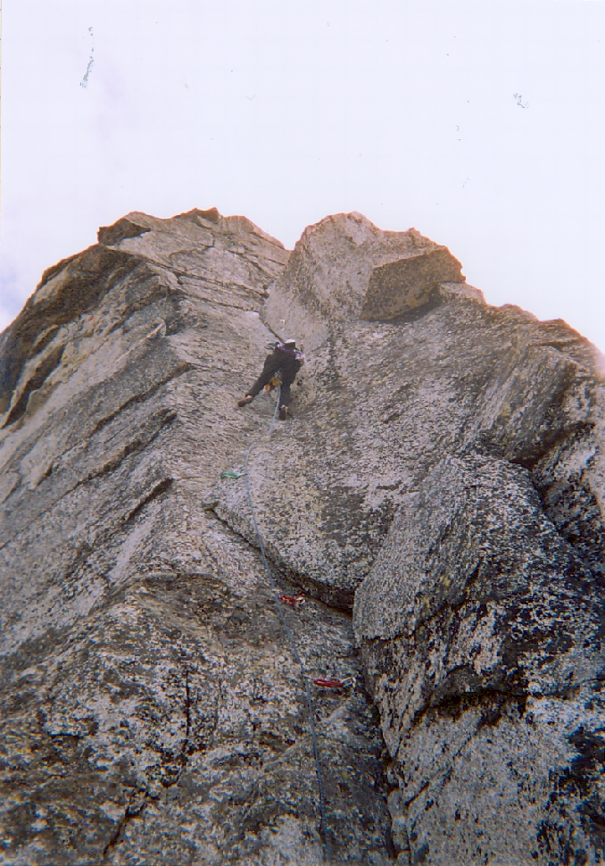
next pitch looked much more murky. Apparently one was to go up three feet, then traverse
right ten or so feet with no obvious pro, and then enter the off-width, whose position we
could more guess than see from the belay. Paul started out and, as we had suspected, was
unable to protect until he reached the off-width. Falling there would be a bad idea,
certainly for the leader, and even for the second. After he placed our #4 Camalot in the
crack I felt better. He wiggled up by means of what looked like extremely awkward moves,
announced that he had clipped the famous fixed cam, then continued with what looked like
more reasonable crack climbing. When the crack petered out he cut left onto the face (in
retrospect this was probably a mistake, we should have gone right), ran
it out thirty feet, which made me cringe, and announced that he was done with the gendarme.
After hauling the packs, which took forever and tore a hole in our favorite homemade pack,
I followed. The first few feet of the off-width are awkward indeed. I was unable to
get fist jams, so I finally did an arm bar to get going, then laybacked the left edge to
easier ground. To me it felt more like 5.10b than 5.9 (and MUCH harder than the previous
pitch), but I don't have a lot of off-width
experience and I was getting tired at that point. I managed to get the pro out without
hanging, and when I joined Paul we relished the fact that we had both done the
Great Gendarme free.
From here on it was supposed to be a few easy pitches to the summit, or so we thought, so
I led off from the top of the gendarme expecting that I soon would be able to announce that
we could simul-climb this. Not so. The climbing stayed at about 5.7, and judging from the
looks of the lichen people don't go there very often. From the top of that pitch things
still looked dark, forbidding, and hard. We recited Beckey's route description, which did
not help much, then I discovered a rap sling some fifty feet off to the right. So after all
we weren't the first idiots who had gone off route. I traversed over to the sling, and
decided to use it. A fifty-foot rappel brought us to the start of a sandy couloir that
looked rotten and turned out to be even more so when I led it. The next pitch was again
much harder than it looked, and we started to seriously wonder what was wrong with us.
The sun was getting low, and fog started to engulf us. We had observed this cloud
formation the night before and knew that it did not mean anything, so we were not worried,
but we badly wanted to get done with the climbing at that point.
After that pitch (#16) we finally reached fourth-class ledges and started to simul-climb.
After what still seemed like an eternity Paul, who was in the lead, started making some
excited noises. I could not understand what he was shouting, but figured that he was on
or close to the summit. Indeed, within minutes we both stood on the granite slab that
forms the true summit of Stuart. It had taken us 9 hours 45 mins to get here from the
notch. Somehow we've got to work on the fast part of the light-and-fast business!
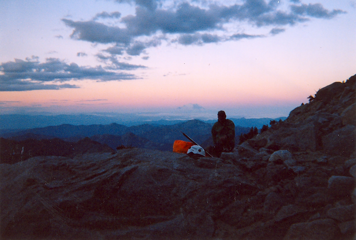
As expected, a cold and strong (20mph) wind was blowing from the SE, the sun was setting,
and this was not the time for an extended summit rest stop. We took two pictures
(one of me against the setting sun, stupidly, and one of Paul that turned out quite nice),
and decided it was time to get out of there. We scrambled over to the false summit,
passing a lot of otherwise nice bivy sites that were all fully exposed to the wind. The
Cascadian was obvious, thank goodness, and we figured our best shot was to drop down as
fast as we could in the failing light to get out of the wind. Paul's feet were killing
him, so he switched to sneakers, while I was still comfortable in my rock shoes (bless
the old-style FiveTen Huecos!), and it was funny to see how I stuck to the rock wherever
I could, while Paul slid in the dirt wherever he could. We dropped about 1,600' in a bit
less than
an hour. At that point it was getting seriously dark, the wind was not as strong anymore,
and we had reached what looked like the last snowfield, so we decided to call it quits.
The bivy site was quite a room with a view, with Mt. Rainer majestically poking over our
windbreak. Paul was comfortably warm in his down bag but complained about rocks underneath,
while I was lying comfortably but complained about being cold. I tried a space blanket, but
the wind kept blowing it away and I spent much of the night fighting it. Amazingly, though,
my feet, stuffed inside a pack, where nice and warm. Still, we got a good rest, and even
quite a bit of sleep, and were not in a hurry to get going again the next morning.
After a breakfast bar, and filling our water
bladders with snow, we continued down. It was quite a scramble at times, and we were glad
that we had not tried this in the middle of the night. Cross-country travel proved impossible
below tree line, so we followed the climbers trail down until we intersected the trail leading
up the valley. Our next task was to find Monique. We turned upstream, and after 15 minutes or
so came to a junction with a big sign pointing to Long's Pass one way, and to Stuart Pass the
other. So what are people talking about it being hard to find the way to Long's Pass? We hiked
through some really nice forest, and whenever the trail leveled off we said, "surely she's
camped around here". No sign of any camp, though. After an hour or so we started to wonder
what on earth was wrong, when I finally spotted what looked like an MSR fuel bottle on a
boulder. Sure enough, that was her stove, and the tent was pitched a bit uphill in a really
nice meadow. We ate our first hot meal in thirty hours, and Paul and I took a nap. Then we
packed up, shouldered the mighty packs, and trotted downhill again towards the Long's Pass
junction.
Paul and I were just tired enough to slow us down to Monique's pace, and we reached Long's Pass
almost simultaneously. After a last look at the Stuart Range, and pointing out our bivy site
to Monique, we ran down to the trailhead. We reached Seattle just in time so Paul could take
a shower before going to his meeting (they would surely have thrown him out otherwise), and
Monique and I took off again for the long drive down to Eugene. The weather in the Oregon
Cascades looked ugly, and we realized how lucky we had been. Great trip, but next year we've
got to do the West Ridge of Forbidden!