|
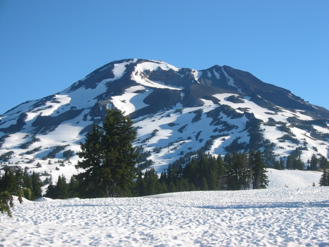
South Sister (10,358') is the third-highest mountain in Oregon. The South Side route is an easy, although arduous (due to
the almost 5,000' elevation gain from Devils Lake), hike that can be done in sneakers even in mid-June, provided the
weather is good and you don't mind getting wet feet. Don't get intimidated by the hordes of people on the trail who carry
equipment that would be adequate for K2, but don't hesitate either to switch to boots or turn around altogether if you
encounter icy conditions near the crater rim. As on all high volcanoes, of course, bad weather can drastically increase
the seriousness of the trip. The South Side also provides
a superb ski descent. Contiguous, or almost contiguous, snow usually can be found from the summit to the flats at around
6,800' until early July. Later in the year the route is just an endless scree slog. The East Side (from Green Lakes)
provides a nice variation that is much less traveled. Prouty Glacier (also approached from Green Lakes) is a technical
climb, and/or an extreme ski descent.
|
South Sister from the south in early July
(photo credit: Jörg Rollbühler)
|
|
Topo Map
|
|
Routes:
S Side (I, Class 1, moderate ski descent)
 S Side Variation (I, Class 2) S Side Variation (I, Class 2)
References:
Jeff Thomas, Oregon High Keep Climbing Press (Portland, OR 1991)
 J. Smoot, Summit Guide to the Cascade Volcanoes
Chockstone Press (Evergreen, CO 1992)
J. Smoot, Summit Guide to the Cascade Volcanoes
Chockstone Press (Evergreen, CO 1992)
N.A. Dodge, A Climbing Guide to Oregon ,
Touchstone Press (Beaverton, OR 1975)
|
Date: May 19, 2018
Party: DB solo
Route: South Side, ski descent
Equipment: AT skis, whippets
Time: Devils Lake - Summit: 7 hrs 5 mins
 Summit - Devils Lake: 2 hrs 45 mins
Roundtrip from Devils Lake: 10 hrs 15 mins
Comments: Snow line at Devils Lake, contiguous snow started 350' vertical up the gully.
Trip report: The snow pack was not great, so Cascade Lakes Highway had openened early.
I started from the highway at 8:15 and reached the top of the gully after a bit of an hour.
There clearly were a lot of people on the mountain, but unfortunately the butt glissaders
had obliterated virtually all boot tracks, so whenever it got too steep for skinning I had
to kick steps, which slowed me down. While working my way up to the saddle at the base of
Lewis Glacier I noticed a helicopter circling over the lava flows below, and hoped it was
on a training flight (it was not, as I found out later). The ridge from the saddle was
still mostly snow covered, and I skinned again for a while until I switched back to boot
packing for getting up to the crater rim.
The wind had picked up a bit, and some squalls were moving in from the west, consistent
with the forecast. However, as I had observed on previous trips, the squalls had a tendency to get
diverted to Middle Sister, leaving South Sister alone. It was getting late by the time
I got to the summit, so I did not linger long, took in the views, took off my skins,
and started down.
The snow was remarkably good. For the first 2,000' vertical or so I found a very good
approximation to actual corn, and from there to the pumice flats the snow was still
very decent. Once I got to the top of the only really steep step on the obvious
descent line I realized that the helicopter had not been on a training flight: at the
bottom of the step a rescue crew was busy preparing someone for a litter trip down to
the helicopter, which had landed about 1,000' lower. I sideslipped the steep section,
as I usually do, and proceeded to the flats where I had a late lunch. On my way across
the flats I ran into the other half of the rescue squad, who were on their way up on
snow shoes and inquired about the location of the chopper.
The gully was reasonably skiable, and I was able to ski down to about 350' vertical
above the highway. Very nice trip, and excellent skiing by Oregon standards, although
I was a bit dismayed that the ascent had taken me so long.
Date: June 21, 2016
Party: DB solo
Route: South Side, ski descent
Equipment: AT skis, whippets
Time: Devils Lake - Summit: 6 hrs 20 mins
Summit - Devils Lake: 3 hrs 10 mins
Roundtrip from Devils Lake: 10 hrs
Comments: The snow line was at 6,000', but the gully was not reasonably skiable.
Trip report:
Date: June 2, 2007
Party: DB solo
Route: South Side, ski descent
Equipment: AT skis
Time: Devils Lake - Summit 6 hrs 30 mins, roundtrip from Devils Lake 10 hrs
Trip report: Another year of low snow pack in the Oregon
Cascades led to an early June trip under conditions that reminded me more of early
July. I started from Devils Lake at 6am and made it to the flat area in a bit over an
hour. At the top of the approach gully I ran into John and Lisa Manotti and friends.
They were skinning, whereas I had opted for sneakers, carrying my skis and boots.
I noticed that I had not climbed anything in a long time: it took me six hours
to the crater rim, and 6 1/2 hours to the summit. The weather was nice, and the
thunderstorms did not start building until early afternoon. It was nice and warm,
with calm winds, and I spent over an hour lounging on the summit.
When I started down I noticed that it was too warm for good skiing, though: the snow was
too soft, but the skiing was still fun. I managed to ski about 2/3 down the approach
gully, and the snow there was actually good, so zipping through the trees was fun
rather than the usual survival skiing. While hiking out the last 15 minutes it rained
a bit on me, and while driving south on Cascade Lakes Highway I got caught in one of
the worst hail storms I have ever experienced. It was a good trip, and it was good to
get out again after a long hiatus.
For earlier ascents, click here .