Routes: South Ridge (I, 5.1)
|
|
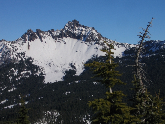
Three-Fingered Jack is an impressive-looking, highly eroded volcano that had
gained an "unclimbable" reputation before the first ascent by Ervin McNeal and
party in 1923. The rock is horrible in general, but the South Ridge (the only
recommended route) is a very enjoyable climb with solid rock on the crux. The
knife-edge summit is spectacular.
Routes: South Ridge (I, 5.1) |
|
|
| References: Jeff Thomas,
Oregon High
Keep Climbing Press (Portland, OR 1991)
|
||
Date: August 19, 2017
Party: DB solo
Route: S Ridge
Equipment: 50m rope
Time: Santiam Pass - Summit 4 hrs 15 mins
![]() Summit - Santiam Pass 3 hrs 15 mins
Summit - Santiam Pass 3 hrs 15 mins
![]() Roundtrip from Santiam Pass 7 hrs 30 mins
Roundtrip from Santiam Pass 7 hrs 30 mins
Comments: Time up includes about 30 mins scouting for an eclipse viewing spot
Trip report:
The main purpose of this trip was to find a good spot to view the 2017 total solar eclipse from. Since I was up there anyway I figured I might as well climb Jack. There were big fires burning both to the North and to the South, and the air quality was horrible after about 11am. From the summit I could see neither Jefferson nor the Sisters, nor anything else for that matter. I actually developed a headache from the smoke, even though I deliberately took my time going up. This also made me worried about the eclipse viewing conditions two days later, but some people reported the previous day it had been okay, so apparently it just depends on the atmospheric patterns.
Speaking of my note from last October about breaking holds: I did break a large hold that I had not expected to break. Fortunately, on Jack I always expect to break holds that I don't expect to break, so it was okay.
Date: October 11, 2016
Party: DB solo
Route: S Ridge
Equipment: 50m rope
Time: Santiam Pass - Summit 3 hrs 35 mins
![]() Roundtrip from Santiam Pass 6 hrs 30 mins
Roundtrip from Santiam Pass 6 hrs 30 mins
Comments: Cold, windy, and icy
Trip report:
I had missed a perfect day the previous Sunday due to a flawed weather forecast, so I took advantage of what looked like the last chance this season to do an alpine climb in summer conditions. It was cold, foggy, and windy all the way to The Crawl, and once I reached the ridge I had doubts about going to the summit due to freezing fog that produced verglas. However, it turned out that the technical part was dry, except for the first few feet of The Crawl, which required care due to water ice that resulted from dripping icicles above. It was a winter weather pattern, with fog all over Central Oregon and a strong easterly wind that pushed the fog over the crest. Very impressive, but cold. It didn't help that I started rather early since I needed to be back in town for work by 4pm. It all worked out, though, and I even broke my personal round-trip record for Jack. Oh, and for the record: The climbing on Jack is actually quite good, which is much more than I can say for the North Ridge of Washington, although even on Jack I'm always paranoid about breaking a hold.
Date: October 19, 2013
Party: DB solo
Route: S Ridge
Equipment: 50m rope
Time: Santiam Pass - Base of summit block 3 hrs 45 mins
![]() Roundtrip from Santiam Pass 8 hrs 10 mins
Roundtrip from Santiam Pass 8 hrs 10 mins
Comments: Surprising amounts of snow and a large party on the summit slowed me down.
Trip report:
After four weeks of horrible weather it was finally nice, and I figured this was my last chance this year for a climb in summer conditions. It turned out conditions were more like late spring, with a surprising amount of three-week old snow above about 6,000'. The snow was too icy for kicking steps with sneakers, which forced me onto the southern part of the scree fields, which made for very slow going. The technical part was dry, though. Below the summit block I enjoyed the views while a large party was going up and back down. I don't think I've ever seen that much snow in the Oregon Cascades that early in the season; a huge storm in late September must have dumped amazing amounts. The sun felt stronger than late October, though; I even go a mild sunburn.
Date: September 30, 2011
Party: DB, Rudy Kohnly, Dave Ruuhela
Route: S Ridge
Equipment: 60m rope, small rack of stoppers and camalots
Time: Santiam Pass - The Crawl 3 hrs 45 mins
![]() Santiam Pass - Summit 6 hrs
Santiam Pass - Summit 6 hrs
![]() Roundtrip from Santiam Pass 11 hrs 35 mins
Roundtrip from Santiam Pass 11 hrs 35 mins
Comments: Belayed most of the terrain above The Crawl
Trip report:
Rudy, Dave, and I had been talking about Jack for quite a while, and we finally got around to doing it. Rudy and Dave started from Portland, I started from Springfield, we arrived at the trailhead almost simultaneously, and twenty minutes before sunrise we were on our way. We hiked through the burn area, where the new trees are getting taller every year, and made good time to The Crawl, where we roped up.
Some people keep placing pins on The Crawl (in idiotic places where they don't even do any good), and then leave bright red slings on them, complete with a biner attached. WTF?? I hope these things get chopped!
Everything went very smoothly, but with three people progress was slow, especially since we opted for belaying much of the terrain between The Crawl and the summit block. In due course we all got to the true summit, though, where Dave got some very nice pictures.
After lunch at the base of the summit block we made it back down, and on the hike out we admired the sunlight on the snags in the burn area, which makes them look as if they had snow on them. After a bit over 11 1/2 hours, and with half an hour to spare before sunset, we were back at our cars. Very nice trip!
Date: July 28, 2010
Party: DB solo
Route: S Ridge
Equipment: 50m half rope
Time: Santiam Pass - Summit 3 hrs 15 mins
![]() Summit - Santiam Pass 3 hrs 20 mins
Summit - Santiam Pass 3 hrs 20 mins
![]() Roundtrip from Santiam Pass 7 hrs
Roundtrip from Santiam Pass 7 hrs
Comments: Time down includes Point 6,961
Trip report:
I needed a training climb for my upcoming trip to the High Sierra, and opted for Three-Fingered Jack. There was a surprising amount of snow left, and the mosquitoes were accordingly vicious, but apart from that everything went very smoothly. I switched from sneakers to rock shoes at The Crawl as usual, and soon was on the summit. The views were not as good as they can be because of a hazy overcast sky. On the way down I found that the rappel anchor on the summit block was rigged in a very weird way that I was reluctant to trust. I did not carry any slings, and was too lazy to change the existing setup (plus, the main anchor was very high in a place where I did not really want to go), so I downclimbed, using my rappel setup as a self belay. This meant downclimbing mostly one-handed, of course. If this sounds weird, I'm sure it looked even weirder, but there was nobody around to watch me.
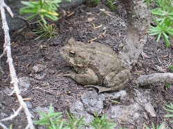
Because of the mosquitoes I decided to not go straight down to the PCT but rather stay on the ridge and descend via the ski summit (Point 6,961) where there was a breeze. This worked fine, and on the way down from the ski summit I saw a surprisingly large toad (Western Toad, bufo boreas) in an area where the snow had just melted. A mixture of scree and snow fields got me down to the PCT, and a bit over an hour later I was back at my car.
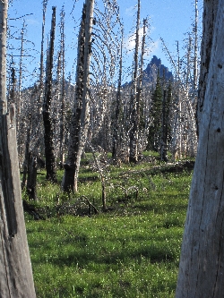
View of Jack from near the trailhead. |
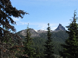
Jack and the Ski Summit from the PCT. |
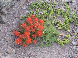
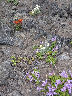
Wildflowers high on the ridge. |
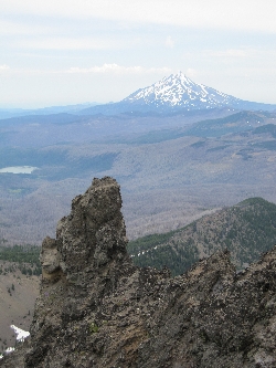
View of Mt. Jefferson from the summit. |
More wildflowers. |
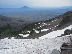
View of Black Butte across the snow fields. |
||||||
The toad. |
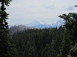
Mt. Washington and the Three Sisters from the PCT. |
Date: September 4, 2008
Party: DB solo
Route: S Ridge
Equipment: 50m half rope
Time: Santiam Pass - Summit 3 hrs 20 mins
![]() Summit - Santiam Pass 3 hrs 10 mins
Summit - Santiam Pass 3 hrs 10 mins
![]() Roundtrip from Santiam Pass 7 hrs 15 mins
Roundtrip from Santiam Pass 7 hrs 15 mins
Comments: I took it easy both up and down
Trip report:
I took my chance on a perfect September day to get out again after quite a while. I wanted to go solo, but needed a training climb for a planned trip to Tuolomne Meadows, so I settled on Jack. On the approach hike I noticed that a lot has changed in the burn area since I last came trough there two years ago: there now are lots of small trees around, between 6" and 2' tall. The higher the elevation, the smaller the seedlings, which makes sense. Almost all of the charred snags are still standing, but now, 5 years after the fire in 2003, one can certainly imagine the new forest. That will be the end of the wild flowers and the manzanita that are now thriving there. It's fascinating to see how the area changes and recovers after the fire, with several layers of different plants moving in over time.
I made steady progress and reached the climbers trail after a little less than two hours. After a food and drink stop I started up, managed to go into the notch on the ridge this time, rather than too far north, and soon arrived at The Crawl. Here I cached my sneakers and put on rock shoes, and enjoyed the short pitch on amazingly solid rock. On the summit block, on the other hand, I keep wondering about the quality of the nobs, especially while free soloing. The summit was nice as always, and on the way down I used my 50m half rope to rappel the chimney. Why tempt fate by downclimbing, given my doubts about the quality of the holds?
After a lengthy lunch break I reversed The Crawl, skidded down the scree to the PCT, made a couple calls to announce my safe return to my family, and enjoyed the view through the snags on the hike out. Rotten rock or no rotten rock on the summit block, the South Ridge of Jack is an amazingly enjoyable climb, and this was the ultimate free solo: There was not even another party on the mountain.