Routes: SW Ridge (I, 3rd Class)
References: Colorado's Fourteeners by Gerry Roach (Fulcrum, 2011)
|
|
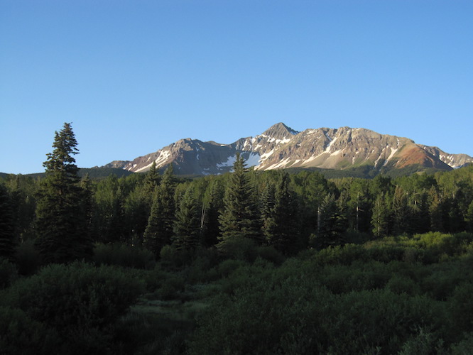
Wilson Peak is the lowest and most easily accessible main summit in the Wilson group,
which also includes two higher 14ers: Mt. Wilson, and El Diente. It is, however, the
most conspicuous summit in the group: It is the characteristic pyramid that is visible,
for instance, from the Telluride gondola. The rock is just
as chossy as everywhere else in the San Juans (or the Elks, for that matter), so
it's a good thing that the SW Ridge is only 3rd class.
Routes: SW Ridge (I, 3rd Class)
|
|
|
Date: July 1, 2017
Party: DB solo
Route: SW Ridge
Equipment: whippets
Time: Trailhead - Summit: 6hrs 15mins
![]() Summit - Trailhead: 3 hrs 40 mins
Summit - Trailhead: 3 hrs 40 mins
![]() Roundtrip from trailhead: 10 hrs 10 mins
Roundtrip from trailhead: 10 hrs 10 mins
Comments: I took the long way up due to a relocated trailhead
Trip report:
I had been thinking about Wetterhorn Peak in the Uncompahgre Group, only to realize that that's way too long a drive for a day trip from Telluride. Then I thought about Mt. Wilson, with a repeat of Wilson Peak as a Plan B in case conditions weren't right or I was taking too long. I had no way of printing a map, and so I started out with just a memorized version of the description in an old (1998) version of Roach's book and whatever I could remember from a previous climb in 1995 (which was virtually nothing, as it turned out).
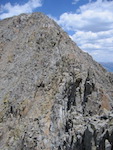
As it turned out, the public access situation has changed dramatically since 1995; the trailhead is no longer located in Silver Pick Basin, but in the next basin over to the west. I did not realize this, left the jeep trail as soon as I spotted something resembling a climbers trail, and headed for the saddle I could see above. The "climbers trail" disappeared in due course, and I had to work hard to gain the saddle via bad scree. Once there, the drop into Navajo Basin looked like a lot more than the 700' vertical I expected. More worrisome, Wilson Peak was not even visible. I realized that I was in the wrong saddle, at 13,240', since I had gone up the wrong basin. Fixing that mistake involved a lengthy traverse on terrain that was bad even by Colorado standards: A mix of stuff from a few inches cubed to about 2 feet cubed, all sitting right at the angle of repose. It took me forever to lose about 400' vertical and cover maybe half a linear mile in a semi-controlled way to gain the right saddle at just over 13,000'. From there the drop into Navajo basin looked more like what I had expected, but I had lost so much time that Mt. Wilson was out of the question. I also was concerned about the snow, which was much harder than I had expected, and I did not carry crampons. So I executed my Plan B and set out towards Wilson Peak. After some easy scrambling I came upon the final 150', which turned out to be serious 3rd class. Strangely, I did not remember that at all from my 1995 climb; I remembered the trip as a hike. The rock was not too bad on that section, though, and after waiting for a guide with a client to pass through on their way down I quickly gained the summit. Due to my route finding error it had taken me over six hours to get there.
The views were as nice as I had expected, and I could also see the entire northern route up Mt. Wilson. Even from that vantage point Mt. Wilson does not look impressive! It's clearly Wilson Peak first, El Diente second, and Mt. Wilson third in terms of majestic looks!
To get down I took the snow fields from the right saddle into Silver Pick Basin, where boots and whippets came handy, and then picked up the trail that leads over to the basin I had started out from. That new approach makes the route substantially longer, and it despite maintaining a good pace it took me 3 hrs 40 minutes from the summit back to my car.
It was not bad for a Plan B, but next time I'm in the area I should try Mt. Wilson. Done properly it cannot be much more effort than I expended on this trip!
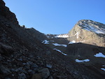
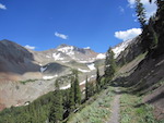
On my way up the wrong basin. |
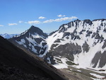
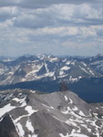
View of Mt. Wilson and Gladstone Peak from the 13,240' saddle. |
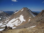
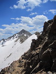
View of the 13,000' saddle from the notch in the SW Ridge. |
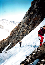
The 3rd class section to the true summit. |
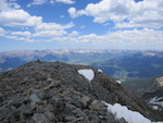
View West from the summit. |
View of Lizard Head from the summit. |
||||||
View down the SW Ridge towards Gladstone Peak. |
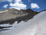
View of the snow fields below the 13,000' saddle. |
View of Silver Pick Basin from the trail. |
Date: July 26, 1995
Party: DB, Thomas Vojta, Agnes Vojta, Matthias Vojta
Route: SW Ridge
Equipment: ski poles
Time: Gate on Silver Pick Rd - Summit 3 1/2 hrs
![]() Roundtrip from gate 6 1/2 hrs
Roundtrip from gate 6 1/2 hrs
Comments: We did not manage to drive quite to the gate at 10,200'
Trip report:
We did the route in an afternoon, which reqired a crazy pace. Impressively, Agnes and Matthias, who had just arrived from sea level, kept up with Thomas and me, who were acclimatized. The snow line was at 10,500', but the ridges were bare.
Thomas and Agnes Vojta at about 13,500' on the final ridge to the summit. |