The Galapagos Archipelago  


The Galapagos Archipelago: An Active Environment of Geologic Splendor

Overview

The Galapagos Archipelago, frequently termed Darwin's Islands, steam with geologic activity of the past and present. Located 600 miles from the nearest shore, the islands have an abundance of biological and geological phenomenon. The Galapagos Islands are one of only a handful of "hotspots" located on Earth. A hotspot is the product of a mantle plume extending from deep within the mantle and pooling beneath the Earth?s crust. This mantle plume erects volcanic islands, causes earthquakes and warps the crust forming what we call the Galapagos Platform.

The Galapagos Islands form in a region that has numerous other active tectonic processes, such as the Galapagos Spreading Center and the South American subduction zone. The physical contact between these dynamic geologic processes have produced fascinating geologic features, such as the Cocos and Carnegie Ridges. This guide will give you a step-by-step discussion of the geologic processes that have created and continue to form the Galapagos Archipelago and the region that surround it.

Primary Author: Bree Burdick
Contributing Authors: Emilie Hooft-Toomey, Darwin Villagomez
Edited By: Emilie Hooft-Toomey and Douglas R. Toomey


The Regional Setting of the Galapagos Archipelago

Regional View of the Galapagos Archipelago

A regional view of the Galapagos Archipelago. The submerged Carnegie and Cocos Ridges and the Galapagos Platform are a light red color. The Galapagos Islands sit atop the Galapagos Platform and are colored light blue. Bathymetric and topographic data compiled by: Smith, W. H. F. and D. T. Sandwell, Global Seafloor Topography from Satellite Altimetry and Ship Depth Soundings, Science, v. 277, p. 1956-1962, 26 September, 1997.


     The Galapagos Islands are a group of islands located 600 miles west of Ecuador in the east Pacific Ocean. These islands are formed by volcanic activity occurring in the middle of one of Earth's tectonic plates. The present-day Galapagos hotspot shows an above surface expression of a group of oceanic volcanoes composed of thirteen major islands. The past location of the hotspot can be traced as two ridges on the seafloor, the Cocos and Carnegie ridges, which extend from the Galapagos Archipelago to the Central and South American trenches, where they are subducting into the mantle. These ridges are similar in age and formed when oceanic crust moved over the Galapagos hotspot, leaving a pathway for animals to migrate over time. It is believed that the Galapagos Archipelago has existed continuously for the past fifteen million years.

Regional Tectonic Plates of the Galapagos Archipelago

A regional view of the Galapagos Archipelago, including boundaries of the adjacent tectonic plates. Bathymetric and topographic data compiled by: Smith, W. H. F. and D. T. Sandwell, Global Seafloor Topography from Satellite Altimetry and Ship Depth Soundings, Science, v. 277, p. 1956-1962, 26 September, 1997.


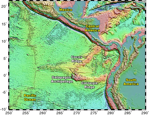
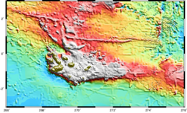
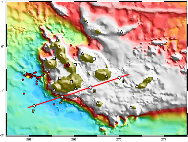
     The Galapagos Islands are a group of volcanic islands, called a "hotspot". This group of islands are formed by volcanic activity occurring in the middle of one of Earth's tectonic plates. These volcanoes form above the present-day Galapagos hotspot, showing an above sea-level expression of a group of oceanic volcanoes composed of thirteen major islands. The past location of the hotspot can be traced as two ridges on the seafloor, the Cocos and Carnegie ridges, which extend from the Galapagos Archipelago to the Central and South American trenches, where they are subducting into the mantle. These ridges are similar in age and formed when oceanic crust moved over the Galapagos hotspot, leaving a pathway for animals to migrate over time. It is believed that the Galapagos Archipelago has existed continuously for the past fifteen million years. These volcanoes form above a rising plume of hot mantle material which, upon reaching the earth's surface, melts and emits basaltic lava that builds up to form oceanic islands. The upward motion of the mantle plumes pushes on the overlying lithosphere. This, together with magmatic thickening of the crust, is responsible for the Galapagos Platform, a shallow region of the ocean upon which the Galapagos Islands sit.
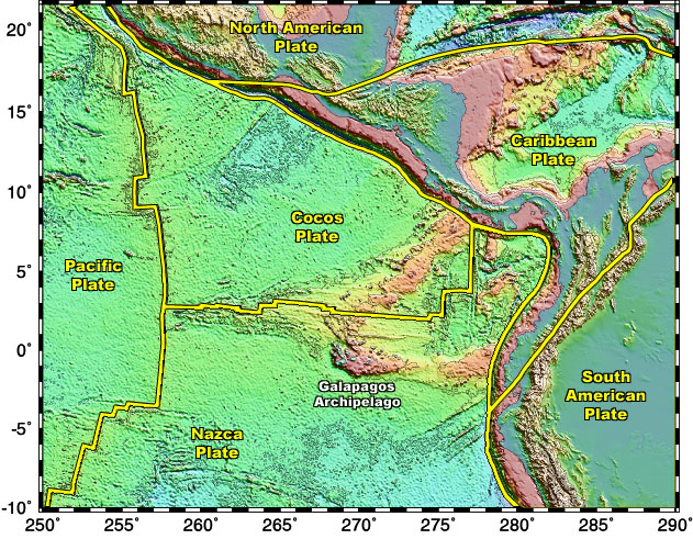
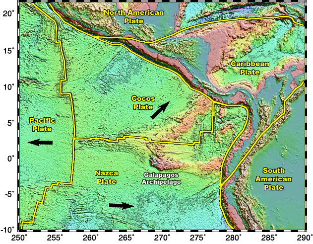
     These islands form near three active tectonic plates, the Cocos, Nazca and Pacific plates. The Galapagos Islands are located on the Nazca plate, which is south of the Cocos plate and east of the Pacific plate. These three plates are separated by two common spreading centers, called "mid-ocean ridges", located between the Cocos and Nazca plates and the Pacific and Nazca plates. Spreading centers are divergent plate boundaries that emit magma to form new oceanic crust. As new crust is made, the Cocos and Nazca plates migrate perpendicular to the direction of the spreading centers until they collide with Central and South America, respectively, and subduct beneath the more buoyant continental-oceanic plates, the Caribbean and South American plates. The mid-ocean ridge between the Pacific and Nazca plate is called the East Pacific Rise and the other ridge, located between the Cocos and Nazca plate, is called the Galapagos Spreading Center. The Galapagos hotspot is only 100 km south of the Galapagos Spreading Center. Interaction between the mantle plume and spreading center can account for the distinct composition of the Galapagos magmas compared to other hotspots.

Regional Kinematics of the Galapagos Archipelago

The direction of the migrating tectonic plates is annotated by the black arrows. Bathymetric and topographic data compiled by: Smith, W. H. F. and D. T. Sandwell, Global Seafloor Topography from Satellite Altimetry and Ship Depth Soundings, Science, v. 277, p. 1956-1962, 26 September, 1997.


     The Galapagos plume has a fixed location while the tectonic plates move above it. The Galapagos plume have not produced such as simple linear chain as the Hawaiian Islands or the Society Islands. Nevertheless, the islands do get older to the south-southeast (Espanola is the oldest Galapagos island). The Galapagos Islands are located on the Nazca Plate, which is moving east-southeast. It converges with the South American plate and subducts beneath it at a rate of seven inches a year. The Cocos plate migrates north, coverging and subducting under Central America. During the Neogene era (approximately five to twenty-four million years ago), the Galapagos Spreading Center was located directly over the Galapagos mantle plume which interacted to form two hotspot tracks, the Cocos and Carnegie Ridges. This chain of volcanos was produced on both the Cocos and Nazca plates. These ridges lie parallel to the movement of the underlying Cocos and Nazca plates. The Galapagos Spreading Center has since migrated to the north.

Regional Earthquake Epicenters of the Galapagos Archipelago

Bathymetric and topographic data compiled by: Smith, W. H. F. and D. T. Sandwell, Global Seafloor Topography from Satellite Altimetry and Ship Depth Soundings, Science, v. 277, p. 1956-1962, 26 September, 1997. Earthquake (PDE) data retrieved from: http://www.neic.cr.usgs.gov/neis/epic/epic_global.html


     Deep trenches at plate boundaries mark subduction zones. The Peru-Chili Trench is located east of the Galapagos Islands at the Nazca and South American plate boundary. The Mexico Trench is located north of the Galapagos Islands at the Cocos and Caribbean plate boundary. Tectonic plate motion is responsible for most of the seismic activity in the region. Earthquakes are driven by stresses inside the earth. Earthquakes are located at boundaries between the tectonic plates. The "great earthquakes" (magnitude 8 or higher) usually occur at subduction zones. Since the oceanic plate does not subduct smoothly under the continental plate (rather, it sticks), over time stress builds up and is suddenly released causing a large earthquake. Subduction zone earthquakes, like those along the Mexico and Peru-Chili Trench, typically produce ground shaking that lasts for over a minute or two and have many aftershocks. Since the Mexico and Peru-Chili Trench are located just offshore, when an earthquake occurs damaging tsunamis may follow. Because subduction zones mark the area where one tectonic plate moves beneath another earthquakes can occur at deep, as well as, shallow depths. Earthquakes at spreading centers and transform faults are of smaller magnitude and occur at shallower depths. Transform faults offset spreading centers. A major transform fault is located just north of the Galapagos at 91°W.


The Local Setting of the Galapagos Archipelago

Galapagos Archipelago Bathymetry

The Galapagos Islands sit atop of the Galapagos Platform, highlighted by the color white. Bathymetric data compiled by William Chadwick, Oregon State University.


     The upward motion of the mantle plumes pushes up the overlying lithosphere. This, together with magmatic thickening of the crust, is responsible for the Galapagos Platform, a shallow region of the ocean upon which the Galapagos Islands sit. The bulge can be clearly seen along the western and southern margins of the island of Isabela. This bulge disappears as you move eastward along the southern margin of the platform. This is due to the Airy compensation which dominates in the central platform. The Galapagos archipelago is composed of several major volcanic islands which rest atop a large platform. The volcanoes are aligned in a north-northwest orientation, plus perpendicular lineations. These lineations were first noted by Charles Darwin and are termed "Darwinian trends". This trend is supported by structural evidence, such as, parallel linking fissures between the volcanoes and common caldera orientations from a large scale view.

Galapagos Data

A local view of the Galapagos Archipelago. The white squares and triangles are land seismometers used to record seismic waves from earthquakes. The white diamonds are seismometers that were placed on the ocean floor to record human induced seismic waves (see next page), used to map the crust and mantle. The red refraction line and yellow numbers correspond to the cross-section on the next page. The red circles are earthquake epicenters and the yellow star marks the epicenter of a larger earthquake. Bathymetric data compiled by William Chadwick, Oregon State University.


     Although several previous studies of the seismicity of the Galápagos hotspot have been made, little is known about the regional stress field or the neotectonics of the area. Due to the proximity of the Galápagos Spreading Center, the Galápagos platform is built upon very young oceanic lithosphere (<10 m.y.). Main tectonic features of the Galápagos are (1) a N-S fracture zone that crosses the platform and creates a 5.m.y. age offset in the lithosphere, (2) a pronounced NW-SE lineament (Wolf-Darwin Lineament), (3) a series of NW-SE and NE-SW lineaments and volcano alignments (Darwinian trends) on the western part of the archipelago, and (4) steep escarpments along the western and southwestern margin of the platform. The latter are accompanied by a flexural moat and a bathymetric bulge, both of which are absent on the northwestern and eastern margins. The purpose of this study is to correlate this tectonic setting with local seismicity.
     We report epicenters of earthquakes registered by a seismic network deployed in the Galápagos since September 1999. The network consists of ten broadband seismometers and one GSN station, in an array that is over 300 km by 200 km in aperture. During the first year we located 56 events (ml>2.2), using a 1-D velocity model for the platform that assumes a crustal thickness of 15 km. The largest event (5.1 mb) occurred at December 22, 1999 22:08, and was located 40km west of the Archipelago, on the flexural moat. It was followed by 47 aftershocks in the next six months. The Harvard Centroid Moment Tensor for the main event indicates a strike-slip movement with nearly east-west compression. This is in accordance with solutions of previous events in the area, suggesting a constant stress field orientation. The strike of one of the assigned fault planes (295°) is close to the alignment of the epicenters of the aftershocks. We suggest that these events are very closely associated with the flexure of the lithosphere that fractures in response to the loading stress resulting from volcanic construction. Three events (ml=2.3-3.1) were located between northern Isabela Island and the Wolf-Darwin Lineament, on the limits of the platform. The other five events (ml=2.2-2.9) occurred close to the active Alcedo Volcano, and are probably related to its volcanic activity. However, our locations still lack good depth constraint and need to be improved. This data set will be complemented with two more years of data and records from the high frequency stations operating in the area. Ongoing analysis includes obtaining improved locations using a 3-D velocity model that includes topography, and new moment tensor and fault-plane solutions using the stations in our array. The analysis of this seismicity will establish the regional stress field orientation, local stresses in the vicinity of active volcanoes, the role of faults controlling structural and volcanic features, and seismicity related to volcanic activity in the archipelago.

Galapagos Cross-Section

This is a cross-section of the Galapagos Refraction Line, noted by the red reference line in the previous map. The numbers 1, 3, 5, and 7 correspond to the numbers on the previous map.


     The above figure displays a cross-sectional view of the preliminary velocity model and crustal thickness (dark black line) across the Galapagos region. The data is collected from experiments set up on a sea surface craft that release high pressure airgun shots to the bottom of the ocean floor. These instruments cause spherical shaped seismic waves to penetrate the earth. Next, ocean bottom hydrophones and land seismometers record the arrival of the seismic waves projected throughout the crust, mantle, and core. By evaluating the relative time delay from the original location and destination of multiple seismic waves, geologists can determine the velocity gradient (the various speed at which a seismic wave travels through a certain material) and the crustal thickness.
     The above figure records the distance on the refraction line in kilometers. Water depth is shown by white. The triangular markers (labeled 1, 3, 5, and 7) correspond to the seismometers that record the seismic waves. Through noted observations of the graph, speculations on crustal thickness, lower crustal thickness and velocity, and low crustal velocities beneath the edge of the Galapagos platform can be inferred.
     Crustal thickness varies from about 15 km beneath the Galapagos platform to 5.5-6 km on the oceanic crust beyond the edge of the platform. By comparing the thickness of the oceanic crust to the thickness of the crust overlaying the mantle plume, it shows how much excess magma is emitted from the Galapagos mantle plume.
     Lower crustal thickness is about 2/3 of the total crustal thickness both beneath the platform and beyond its edge. This indicates that the ratio of internally cooling to externally cooling magmatic construction of the crust is the same for the crust generated at the mid-ocean ridge as for the additional volcanism that takes place over the hotspot. However, lower crustal velocities are lower beneath the platform than for the oceanic crust (6.5-6.8 km/s vs. 6.5-7.0 km/s), as to be expected, because of the extended range of the crust.
     Crustal velocities are substantially lowered from distances 80-130 km along the line. This corresponds to the edge of the platform and appears to extend into the platform due to the oblique angle that the seismic line makes with the edge. The most likely explanation for these observations is significant faulting associated with the edge of the platform, which is supported by the extremely steep topography found here.