Module Number: EU19
Module Name: The Formation of the Italian Nation
Date:
Introduction
After the fall of the Roman Empire in the 5th century, the communities on the Italian peninsula and its surrounding islands became pawns in the larger struggles of European powers that emerged in the wake of Rome’s demise. It was not until the late 19th century that the separate states of Italy formed a unified modern state and finally brought an end to the long process of unification. Even then, the borders of Italy as it is known today were not finalized until after World War I. In the early Middle Ages Italy was divided and distributed fragmented by the transient dominance of medieval European conquerors from the east (Byzantines), from the south (Muslims) and from the north (the Germans and Normans). As different rulers vied for preeminence in Italy, the Papal State developed a sphere of influence in Central Italy that challenged the claims of the Holy Roman Emperor in Italy. At the same time, northern cities reluctant to cede to Imperial rule formed communes that eventually developed into independently governed city-states. While southern Italy and the nearby islands of Sardinia and Sicily passed between the hands of Spanish, French, and Austrian rulers from the late Middle Ages into the 18th century, the autonomous regimes of northern and central Italy grew and flourished to become formidable powers in and of themselves. By the 1700s, Venice alone had extended its territorial tendrils well beyond the Italian peninsula to stake claims on Istria, Dalmatia and several other significant islands and ports of the Mediterranean. The Napoleonic Era brought Italy almost entirely under French control. After the Congress of Vienna in 1815 the peninsula was returned to its prerevolutionary patchwork of independent states. Despite Austrian and Habsburg attempts to subdue nationalistic fervor, the French had set an example that inspired the Italian states into revolutionary action and by the end of the century the Italian nation had been formed. Indeed it was in 1861 that Victor Emanuel became the new king of Italy and the first Italian parliament elected. |
|---|
Instructions to artist (including "legend / key"):
COLOR KEY Rome: red, Ostrogothic Kingdom: aqua, Byzantines: pink, Lombards: orange, French (Frankish Empire): blue, Germans (Ottonian, Hohenstaufen): gray, Normans: purple, Papal States: white, Spain: yellow, Austrians: green
BASE MAP Close view of just Italy. Include the Arno, Tiber, and Po Rivers and Apennine and Alp mountain ranges. Label cities with a faded black dot to remain visible in all frames: Rome, Venice, Milan, Bologna, Naples, Bari, Brindisi, Palermo, Florence, Benevento, Genoa, Padua, Ravenna, and Pisa. Also label the islands Sardinia, Corsica and Sicily (faded type) as well as the Mediterranean, Tyrrhenian, Ionian, and Adriatic Seas.
Section 1: 300-500 AD
Title: Italy at the End of the Roman Empire
Instructions to artist (including "legend / key"):
Base map should include territory up to that displayed in map 07(including only the borders of the "Kingdom of Odoacer"). Show time intervals from 300 to 500 AD. Frame 1 at 300, Frame 2 at 400, Frame 3 at 476, and Frame 4 at 493.
Mark Roman terrritories in Italy with red to show extent of empire as viewed in map number 137 in Frames 1 and 2. A second map zoom function in each of the first two frames will show the extent of the Empire outside of Italy in Europe. Labeled black arrows with reference to maps 37 and 126 will mark barbarian invasions in Frame 2, but the red base will not change until Frame 3. In Frame 3 and thereafter return to base map and use light aqua to show Odoacer's territories as outlined in map 07. Theodoric's territories should be in aqua indicated by the white outlines from maps 35 and 08. Label Italy as the "Ostrogothic Kingdom" in Frame 4.
Frame 1: Extent of the Roman Empire
Caption: Italy at the Height of Roman Imperial Power
Use map inventory numbers: 10, 137
Extent of the Roman Empire illustrating the limits of Italy and its place in the Empire. |
|---|
Frame 2: Barbarian Invasions
Caption: Early Penetration of Barbarians into the Roman Empire
Use map inventory numbers: 37, 65, 93, 111, 126
Early
barbarian invasions brought Ostrogoths and Visigoths onto the Italian
peninsula in the fourth and fifth centuries and eventually lead to the
fall of the Roman Empire. |
|---|
Frame 3: Fall of the Last Western Roman Emperor
Caption: Italian Peninsula Under Barbarian Control
Use map inventory numbers: 07
The German Odoacer, a general in the Roman army, deposed the last western Roman Emperor, Romulus Augustulus in 476 BC, ruling thereafter from Ravenna until 493. |
|---|
Frame 4: Ostrogothic Kingdom
Caption: Italy Under the Ostrogoths
Use map inventory numbers: 08, 35 (borders only), 112
Theodoric of the Ostrogoths overthrew Odoacer in 493 to become the new king of Italy and established the Ostrogothic Kingdom. |
|---|
Section 2A: 500-1250 AD
Title: Medieval Conquests of Italy
Instructions to artist (including "legend / key"):
Base map is just Italy and surrounding areas. Use a slidebar timeline for frame transitions with intervals between 500 AD to 1300 AD. Key in the upper right-hand corner will indicate significance of the colors and which group they represent (pink: Byzantines, orange: Lombards, blue: Franks, purple: Normans, gray: Germans (Ottonians). Some will remain for several frames, others will disappear. Note that section 2B will appear as a zoom function within 2A similar to the construction of Roman Italy in the Republic on the Mapping History site.
Frame 1: Byzantine Empire
Caption: Italy Under Byzantine Control
Use map inventory numbers: 36, 99
Frame 1 at 500 AD. Show Byzantine territory as pink in Italy and surrounding areas only, using borders from maps 36 and 99. This frame need not include territories in the Meditteranean and Europe.
In the 6th century, Byzantine Emperor Justinian, and his generals, Belisarius and Narses, successfully re-conquered much of the former Western Roman Empire. However his achievements were short-lived, coming to an end after the arrival of the Lombards in 568. Thereafter Byzantine terrritories were confined to the northeast and southernmost tip of the Italian peninsula. |
|---|
Frame 2: Lombard Kingdom
Caption: Italy Under the Lombards
Use map inventory numbers: 06, 12, 35, 64, 110, 136
Frame 2 at 568. Lombard territories will be indicated by the color orange from this frame forward. Map 06 is the best reference for Lombard Kingdom, though the borders in 35 might be easier to follow for the bigger picture. Include the island of Corisca in Lombard possessions and color Sardinia and Sicily pink as Byzantine possessions. Use lighter shades of orange for territories added after initial conquest in 568 ("by 590" on map 06) and label those colors respectively in the the map key in the upper right corner. Use map 06 for Byzantine territories in this frame as well.
The Lombards, a Germanic people, first entered Italy as paid mercenaries for the Byzantine army under general Narses. They soon overthrew the Byzantines and between 650 and 750 gained control of most of the peninsula. |
|---|
Frame 3: Frankish Empire
Caption: Charlemagne's Empire
Use map inventory numbers: 09, 34, 125, 143
Frame 3 at 774. The Frankish territories will be indicated by shades of blue with reference to maps 09 and 125 in particular. Map 63 and 125 (both are quite adequate) indicate the remaining Byzantine territories in Italy to remain pink Mark the Papal States with a black dotted line referencing map 143 and in a bubble add the caption "Rome's self-sufficiency granted by the disinterest of Italy's rulers allowed for the development of the bishopric into the Papacy." Label the Duchy of Benevento in all caps as seen in map 09 with the caption bubble "The Duchy of Benevento, formerly part of the Lombard Kingdom, was virtually cut off from the rest of the kingdom by the borders of the Papal States and thus developed quite independently."
Charlemagne
conquered the Lombard Kingdom of Italy in 774. By 800, he possessed
most of western Europe and was crowned Emperor by Pope Leo III, ruling
until his death in 814. |
|---|
Frame 4: Frankish Empire
Caption: The Partitioning of the Frankish Empire After the Death of Charlemagne
Use map inventory numbers: 62, 97, 98, 138
Frame 4 at 840. Show partitioning of the Frankish Empire with a different shade of blue than that used for the last frame. Lothar's territories are best outlined in map 138 (Charles' and Louis' will not show on this map). Continue to mark the Papal States with a black dotted line (no change since last frame) and again label the Duchy of Benevento (the area surrounding it should be base beige). Byzantine territories do not change from last frame except Sicily which should return to base beige with a caption bubble that reads "Arab Possession After 827". Label the Duchy of Spoleto as seen in map 62.
Charlemagne's son Louis the Pious inherited his father's empire in 814. After his death in 840, his lands were partitioned between his three eldest sons: Lothar, Louis the German, and Pippin I. In the Treaty of Verdun of 843, Lothar recieved the 'middle kingdom' including Italy, becoming Emperor Lothair I. When Lothar died in 855, his kingdom was further divided between his remaining brothers, Charles the Bald and Louis the German. |
|---|
Frame 5: Viking Invasions
Caption: Viking and Magyar Movements in Italy
Use map inventory numbers: 95, 123, 135
Frame 5 at 900. Use last frame as base (no changes) with labeled black arrows to indicate Viking and Magyar migrations using map 135.
As the divided Frankish Empire struggled to mainitain control over its sprawling territories, Viking and Magyar invaders threatened the weakened European west in the 9th and early 10th centuries. |
|---|
Frame 6: Ottonian Italy
Caption: The Holy Roman Empire in Italy
Use map inventory numbers: 11, 107, 122
Frame 6 at 951. Use map 107 as reference for the borders of Ottonian possessions and mark those areas with the color gray (labeled "Germanic Empire" on the key), also including the islands of Sardinia and Corsica. This same area should also be outlined by a bold black line defined as the Holy Roman Empire in the key. Byzantine territories do not change on the mainland and continue to mark the Papal States with a dotted line (no change) and label the Duchies of Benevento and Spoleto. Label northern Italy as the "Kingdom of Italy" with a line in the north near the Alps (see the dotted line in map 11).
The Germanic Ottonians emerge as the dominant European power in the 10th century, invading Italy under Otto I in 951 and taking over those Italian possessions previously held by the under Carolingians. Otto I was crowned King of Italy in 961, and thus began a period of German imperial interests in Italy that would last into the 13th century. |
|---|
Frame 7: Norman Conquests
Caption: Invasions of the Normans
Use map inventory numbers: 05, 14, 32, 60, 124, 134
Frame 7 at 1000. Norman conquests are shown in shades of purple with reference to map 134 . Use shades to indicate territories added and label by year in the key (use dates in 134). Byzantine territories in northern Italy and along the Dalmatian coast remain as does the border of the Holy Roman Empire with the Ottonian (German) possessions still filled in with gray. Continue to label northern Italy as the Kingdom of Italy with the same northern border. Dotted line for the Papal States does not change, but the Duchies of Spoleto and Benevento need no longer been labeled. Sicily should still be base beige.
The Normans (formerly Scandinavian) established a kingdom in Sicily and southern Italy in the early 11th century, eliminating the Lombard principalities and independent duchies. By 1072, the Normans had removed the foreign powers of the Byzantines in southern Italy and the Arabs in Sicily. |
|---|
Frame 8: Norman Conquests
Caption: The Kingdom of Sicily
Use map inventory numbers: 13
Frame 8 at 1130. Few changes from last frame, but color all Norman territories in with no shaded variations (same borders, but now include Sicily). Label southern Italy as "Kingdom of Sicily" with reference to map 13. Revise Papal States to match the dotted line in map 13 as well. No change to northern Italy and the outline of the Holy Roman Empire.
In 1130, Roger II was crowned King of Sicily, Calabria, and Apulia, uniting all the Norman conquests in Italy under the newly formed Kingdom of Sicily. |
|---|
Frame 9: German Empire Under the Hohenstaufens
Caption: Kingdom of Italy
Use map inventory numbers: 17, 33, 105, 122
Frame 9 at 1154. Keep the dotted line for the Papal States but color the area that is purple in map 33 white to match within just those lines. Label in caps as the "Patrimonium of St. Peter". Everything else is the same including lables, borders, and Byzantine and German territories (map 122 shows borders of HRE/German territory, Byzantine Empire, Kingdom of Italy and the Kingdom of Sicily).
Frederick I Barbarossa was crowned King of Italy in Pavia in 1154 and
Holy Roman Emperor by Pope Adrian IV in 1155, effectively bringing all
of northern Italy under German control. |
|---|
Frame 10: German Empire Under the Hohenstaufens
Caption: The Kingdom of Sicily Under Frederick II
Use map inventory numbers: 58, 59, 04, 150
Frame 10 at 1194. Use map 59 for the borders of Hohenstaufen territory (make these light gray to indicate a slight change and the key should read "German Empire Under the Hohenstaufens"), which now include southern Italy (Kingdom of Sicily) and Sicily. Eliminate Byzantine territories. Color in all of the the Papal States previously denoted by a dotted line with white in accordance with map 04 with labeled dotted lines to indicate territories added at different dates (1178, 1219, and 1278 as seen in map 04). Note that the border of the Holy Roman Empire should not change.
Frederick II of Hohenstaufen inherited the Kingdom of Sicily from his mother, Constance of Sicily in 1194. As Holy Roman Emperor until 1250, during his reign , Frederick possessed almost the entire Italian peninsula excluding only the Papal States. The Hohenstaufen Dynasty continued to rule in Italy until 1266 when the troops of Charles of Anjou executed Manfred at the Battle of Benevento and brought an end to the family's Italian line. The increasing power of the Church during the 12th century threatened Imperial authority in northern Italy and sparked an ongoing struggle between the Papacy and the Germanic emperors. Rival political factions arose in favor of the respective parties, the Guelphs siding with the Church and the Ghibellines with the Emperor. Both Frederick I Barbarossa and his son Frederick II campaigned persistently against Rome, placing the Papal Sates in a state of constant battle with the Holy Roman Emperor until the death of Frederick II in 1250. |
|---|
Section 2B:
Title: Northern Italy and the City-States in the Middle Ages
Instructions to artist (including "legend / key"):
Section 2B as a zoom function within 2A as with 'Roman Expansion in Italy' on the Mapping History website. Zoom should cover Northern Italy from the Alps to just above Rome (follow the red outline in map 131 in frame 1 for the northern boundary). Keep those territories labeled in 2A visible in the zoom window as applicable.
Frame 1: Development of the City-States
Caption: Communes
Use map inventory numbers: 131
Place frame 1 as a zoom function within section 2A between frames 7 and 8. As in map 131, distinguish those cities marked with a blue dot with a dot surrounded by a circle. A key will label these cities as communes (note that there will be a separate key for each frame in this section).
By 1080, Lucca and Pisa rejected bishopric and imperial overlordship in favor of establishing their own communes, and promoted protected by regional nobility. The idea of the commune, a consortium of guilds, spread beyond Lombardy and Tuscany during the late 11th and 12th centuries. Communes evolved gradually into formal city-states each with its own internal government. |
|---|
Frame 2: Development of the City-States
Caption: Trade Routes
Use map inventory numbers: 30, 103
Frame 2 should be viewable between frames 8 and 9 in section 2A.
The
success of Italian traders in the 12th century transformed northern
Italy into a flourishing European trade center with maritime routes
that extended from ports like Venice and Genoa to cover the entire
Mediterranean and Atlantic coasts of Europe. Increased wealth
associated with the burgeoning trade market supported the growth of the
northern city-states as they became European centers of learning and
culture during the Renaissance. |
|---|
Frame 3: Lombard League
Caption: Unity of the City-States in 1167
Use map inventory numbers: 61
Place frame 3 with the same position as frame 10 in section 2A. Mark the Battle of Legnano with a crossed swords marker and label in the key as in map 61. Also indicate those cities involved in the Lombard League with a dot surrounded by a circle. Label all cities that are present in map 61.
Titled the Lombard League, twelve northern Italian cities including Milan, Genoa, and Pavia united to defeat the German king Frederick I Barbarossa in 1167 at Legnano, forcing a truce and establishing their independence. In the Peace of Constance of 1183, the League agreed to Imperial taxation and protection in return for peace between northern Italy and the Holy Roman Empire. |
|---|
Section 3A: 1200-1800 AD
Title: High Middle Ages to the French Revolution
Instructions to artist (including "legend / key"):
Section 3A will be a slidebar timeline from 1200-1800 AD using the base map from section 2A before 1300. Section 3B will appear as an aspect of 3A, each "frame" indicating a bubble that will be present in 3A when a particular area is hovered over. The color key for this section should include white: Papal States, gray: Germans, light blue: Angevins (French), shades of yellow: Aragonese (Spain/Habsburgs), and green: Austrians. Holy Roman Empire and the Papal States will remain labeled and outlined/colored as in the final frame of section 2A for the entirety of this section (see map 23 for borders). Keep those areas not included in the colored territories base beige.
Frame 1: Franco-Hispanic Conflict
Caption: Angevin and Aragonese Dynasties
Use map inventory numbers: 23, 29, 58
Frame 1 at 1300. Label southern Italy as the Kingdom of Naples (rather than the Kingdom of Sicily) and fill in the borders of this area indicated by map 58 with light blue. The island of Sicily should be light yellow as should Sardinia. Papal States should remain the same as in previous frames as should the outline of the HRE and the light gray German areas in northern Italy. Key should appear as follows: light blue: Angevins, light yellow: Aragonese, light gray: German Empire, bold black line: Holy Roman Empire, and white: Papal States.
After 1266, the Kingdom of Sicily was ruled by Charles of Anjou until the Sicilian Vespers in 1282 when the displeased Sicilian Barons invited Peter of Aragon to take over the island of Sicily, restricting Angevin territories to the peninsula and renaming them the Kingdom of Naples. |
|---|
Frame 2: Evolution of Territorial States
Caption: Northern Italy from the 13th to the 18th Centuries
Use map inventory numbers: 15, 22, 28, 128
Frame 2 at 1400. Hereafter oultine state territories from section 3B as indicated in map 28 with a black line. Label the following territories in all capital letters: Duchy of Savoy, Duchy of Milan, Republic of Venice, Republic of Genoa, Republic of Siena, Duchy of Modena, Duchy of Lucca, and Duchy of Ferrara. Map 128 is also particularly clear. Remove all shaded gray areas from this point forward and the border of the HRE should match map 52 (see frame 4), uncolored. Note that otherwise the colors in this frame should stay that same as in the previous frame and that some colored areas will overlap with these territories.
Though initally the city-states relied on the governance of collaborating local elites, as the dominant states extended beyond their original territories in the 15th century, they slowly began to develop a more centralized government based on a single ruling family. While Genoa and Venice both maintained their republican regimes, most of the other city-states were ruled by a noble signoria, the so-called Renaissance prince of Machiavellian fame. For the most part the city-states of northern Italy reached their peaks during the Renaissance, after which the once prosperous industrial areas faced a period of decline early in the 17th century with the extensive loss of export markets to northern European competitors. Eventually the more powerful city-states like Florence, Milan, and Venice took the lesser cities and their surrounding areas under their influence to become governed as regional states, thus ending the age of the city-states. |
|---|
Frame 3: Franco-Hispanic Conflict
Caption: Italian Wars
Use map inventory numbers: 51
Frame 3 at 1500. The Kingdom of Naples (still labeled) is light yellow in this frame (territories indicated by map 51). Genoese territories including Corsica and the Duchy of Milan should be light blue in this frame to indicate French possession (map 51), otherwise no change in northern Italy.
Charles VII of France invaded and occupied Naples from 1494 to 1495, claiming the previously Aragonese territories as Angevin property. Thereafter, Italy became a battleground for the Spanish and French powers, sparking the beginning of the Italian Wars which characterized the early 16th century. Fearing Charles VII's increasing power, the majority of Italian troops join with the Spanish army in support of Alfonso II of Naples, forming the anti-French League of Venice. Charles VII was defeated in 1495 and his garrisons recaptured by the Aragonese allies thus returning power to Spain. |
|---|
Frame 4: Habsburg Empire
Caption: Charles V
Use map inventory numbers: 52
Frame 4 at 1600. Holy Roman Empire remains outlined with a bold black line to distinguish it from other Spanish possessions (dark blue line in map 52) in this frame. Color in borders of HRE with yellow to indicate Spanish rule. Kingdom of Naples, Sicily, and Sardinia are now yellow, rather than light yellow with a revised key caption that reads "Spanish Habsburg Empire". Papal States should stay white and unclaimed state territories base beige.
Habsburg
Charles V of Spain increased Spanish holdings in Italy as Holy Roman
Emperor from 1530 to 1558. Already in possession of both Naples and
Sicily, during his reign Charles V also conquered Milan and its
territories thus leaving only Venice and the Papal States outside of
Habsburg control. |
|---|
Frame 5: Habsburg Empire
Caption: Extent of the Habsburg Possessions
Use map inventory numbers: 49, 119
Frame 5 at 1700. Habsburg territories remain in yellow, still including Sicily, Sardinia, and the Kingdom of Naples (unchanged) as well as most of northern Italy. Mark the boundaries of the Holy Roman Empire following the bold red line in map 119. Mark those yellow and gold territories in map 49 (Parma, Milan, Tuscany and parts of the Kingdom of Sardinia) with yellow. Those areas previously under Habsburg control that are not defined by these areas are to return to base beige while the Papal States will remain white with the borders unchanged.
The Spanish Habsburg family ruled in Italy from 1530 until 1701 when the War of Spanish Succession decided the next rulers of Italy. |
|---|
Frame 6: War of Spanish Succession
Caption: Emergence of the Austrians
Use map inventory numbers: 42, 76, 83, 88, 139
Frame 6 at 1800. The Kingdom of Naples (including Sicily) should become green to indicate Austrian possession, as should Sardinia and those small areas indicated by lilac in map 83. City-state outlines remain the same, as should the Papal States. Outline what remains of the border of the HRE (if any) according to map 83 and fill in with green as well. Those territories not included in the Austrian possessions should return to base beige.
The end of Habsburg power brought about the War of Spanish Succession, which lasted from 1701 to 1714. The Treaties of Utrecht and Rastatt ended the threat of a union between Spain and France and bequeathed most of the Spanish territories in Italy to the Austrians with the agreement that should the rulers of either Spain or Austria decide to take the throne in their own country, they would cede their Italian territories. In 1759 Bourbon Charles III of Spain renounced Naples and Sicily after assuming the throne of Madrid. Likewise, Peter Leopold renounced Tuscany in 1790, but Lombardy remained part of the Austrian Empire. |
|---|
Section 3B:
Title: Evolution of Territorial States
Instructions to artist (including "legend / key"):
Frames in section 3B will appear as bubbles triggered when the mouse hovers over them in section 3A. Within section 3A, outline those territories mentioned in 3A frame 2 (except Siena, Lucca, and Modena) with a black line according to map 02 (see 3B, frame 2) from frames 1200-1400 and label as indicated by 3A frame 2 excluding only the territories in parentheses. After the 1400 mark on the timeline, outline and label territories as indicated in 3A frame 2. All other outlines and colors will be in accordance with section 3A. Some changes to borders will occur during the time span of 3A as indicated in the following frames.
Frame 1: Evolution of State Territories
Caption: Treaty of Lodi
Use map inventory numbers: 01, 152
Place bubble between Milanese and Venetian borders. This bubble should appear in the time frame between 1400 and 1500. Map 152 may provide a clearer idea of the boundaries than 28.
In 1454, the Treaty of Lodi established peace between the feuding northern states by defining the permanent boundaries of the Milanese and Venetian territories. The treaty secured a balance of power in northern Italy that excluded the smaller states and confirmed the dominance of Milan, Venice, and its ally Florence. |
|---|
Frame 2: Evolution of State Territories
Caption: Milan
Use map inventory numbers: 02, 03, 15, 101
Place bubble in Milan territories labeled as "Visconti" in map 02 between 1200 and 1500 in 3A.The borders of state territories should follow those in map 02 up until 1400 when they will subsequently follow map 28 for the rest of this section. Those areas labeled "Visconti" on 02, should be labeled Duchy of Milan, those labeled "Savoy" should say Duchy of Savoy, Florence (in light purple on 02) should be Republic of Florence, and "Venetian Republic" should be Republic of Venice. Other territories need not be labeled until after 1400.
As
the dominant noble family of Milan, the Visconti ruled over the state
from 1277 to 1447. In 1387, with aims to submit all of Italy to
Visconti rule, Giangaleazzo Visconti threatened Venice and occupied
Verona, Vicenza, Belleno, and Feltre. After taking over Bologna, Pisa,
and Sienna, Giangaleazzo had control of the entire region of Lombardy,
acquiring the title of duke in 1395. Before he could take Florence as
well, the duke's ambitions were halted by his death in 1402. |
|---|
Frame 3: Evolution of State Territories
Caption: Florence
Use map inventory numbers: 91, 101
Place bubble in Florentine territories indicated by map 28 (02 for 1200-1400) or the dark yellow area in map 91. Bubble should appear in frames 1300 through 1500.
The Medici family gathered prominence as a successful banking family under Cosimo de'Medici in the 13th century Republic of Florence. Officially the Medici were merely citizens of the Republic, but their influence was such that by the 15th century the signoria of the Republic was ruled predominately by Medici factions. Florence was relieved briefly of its Medici overlords in 1495 when Piero di Lorenzo de'Medici fled from Italy, however the Spanish reinstated the Medici in 1512 and effectively put an end to the Republic of Florence. In response to the Milanese campaigns started by Giangaleazzo to expand Milanese territory, in 1406 Florence took over Tuscany and occupied Pisa. |
|---|
Frame 4: Evolution of State Territories
Caption: Venice
Use map inventory numbers: 26, 51, 82, 90
Place bubble in Venetian territories indicated by map 90 in accordance with the timeframe in section 3A. At 1300 and before, Venetian lands should follow outline of the key in 90 in pink ("Venetian Lands 1388"), at 1400 follow dark yellow ("Acquisitions 1406"), at 1450 follow light yellow ("Acquisitions 1421-1453"), and at 1500 follow the dotted boundary. At 1600, mark borders as they appear in the larger map in accordance with the striped "Acquisitions, held after 1600". Label what can be seen of Istria and Dalmatia as Venetian territory.
Under the Venetian Republic, which lasted well into the 18th century, Venice expanded to possess all of northeastern Italy and many settlements outside of the peninsula including Istria and Dalmatia. The Republic's success was in a large part made possible by the wealth generated from its control of European trade in the Levant. |
|---|
Frame 5: Evolution of State Territories
Caption: Genoa
Use map inventory numbers: 24, 50, 51, 91, 101, 103
Place bubble in Genoese territories starting at 1200. Label Corsica as Genoese territory after 1300. On 3A, Genoese territories will be absorbed by France, but thereafter should return to base beige. Label as the Republic of Liguria at frame 1800.
The Republic of Genoa was established in the 11th century as a self-governing commune, eventually expanding to include most of Liguria including the island of Corsica. In 1797, the Republic of Genoa became the Republic of Liguria until 1805 when it was annexed by the French Empire. |
|---|
Frame 6: Evolution of State Territories
Caption: House of Savoy
Use map inventory numbers: 74
Place bubble in Savoy territories throughout entire timeline. Borders in map 74 or 28 (see 3A, frame 2).
The French House of Savoy occupied and governed northern Italian territories bordering Genoa up until the 18th century when their possessions became known as the Kingdom of Sardinia. |
|---|
Section 4:
Title: Napoleonic Era
Instructions to artist (including "legend / key"):
Section 4 will be a timeline from 1789 to 1815. The key should include blue: France, green: Austria (from previous section), and white: Papal States. Use base map from earlier sections to begin, epecially concerning state territory borders and the Papal States. Label Sardinia as the Kindgom of Sardinia, and Naples and Sicily as the Kindgom of Naples and Sicily, in all caps. Continue to label the Republic of Liguria (formerly Genoa) and the Venetian Republic as in the previous section. Savoy lands and Sardinia should now be labeled Kingdom of Sardinia and colored green as an Austrian possession.
Frame 1: French Revolution
Caption: Italy in 1789
Use map inventory numbers: 45, 48, 66
Frame 1 at 1789. Southern Italy still belongs to Austria and should be colored as in the end of section 3A; Papal States and the border of the HRE should also remain the same. Also color those Austrian territories indicated by the red line in map 45 green to match other Austrian possessions. Corsica should now be blue to indicate French possession. Outline areas with a blue line (same color as Corsica) in accordance with the bold blue line in map 48 and label in the key as "French Inspired Republics". Label the Cisalpine Republic in all caps according to map 48.
After the Revolution in France, French revolutionaries invaded Italy in 1796 with the intent of conquering the peninsula. They established the Italian Republic which lasted until 1799, after which it became the Cisalpine Republic and absorbed the territories south of the Po River including Modena, Reggio Emilia, and the Republic of Venice. |
|---|
Frame 2: Napoleon's Conquests
Caption: French Reorganization of Italy
Use map inventory numbers: 85, 86, 87, 115, 116
Frame 2 at 1800. Color French empire in blue and those territories possessed by Napoleon's family members with dark blue according to map 85. Use map 86 to outline the Papal States with a dotted line and outline and label the area named the "Kingdom of Etruria" according to the map. Also label and outline the Kingdom of Naples, the Ligurian Republic, and the Kingdom of Italy. Place a bubble in the area of the Kingdom of Italy with a caption that reads "In 1805 the former Italian Republic became the Kingdom of Italy, governed by Napoleon's stepson Eugene Beauharnais." Another bubble caption over the area surrounding Parma, Guastella, and Piacenza (northern Italy) should read "In 1805 Napoleon made his sister Paolina Borghese Duchess of Parma, Guastella, and Piacenza." Over Naples (labeled Kingdom of Naples) "In 1805 after the defeat of the Bourbon rulers, Napoleon's brother Joseph received Naples." Over Tuscany "Once Napoleon had annexed Tuscany, the region was given to his other sister, Elisa Baciochi." Over Rome "Napoleon's final gift went to his son, Napoleon II, who became King of Rome in 1811 after its annexation to France in 1809." Sicily should be labeled Kingdom of Sicily, and Sardinia as the Kingdom of Sardinia (both base beige).
Napoleon was crowned emperor in 1804, after which he divided the Italian states among his family. |
|---|
Frame 3: Congress of Vienna
Caption: Defeat of Napoleon
Use map inventory numbers: 40, 80, 113, 141
Frame 3 at 1815. In green, color area of Lombardy-Venetia (labeled) according to map 80 and outline in black the Grand Duchy of Tuscany and the Duchy of Modena according to map 40 with a bubble caption that reads: "Lombardy-Venetia was granted to Austria and the Habsburg princes regained control of the Grand Duchy of Tuscany and the Duchy of Modena." Again, fill in the border of the Papal States with white according to their outline in map 40 and add a bubble caption that says: "The Papal States remained under the control of the Pope and returned to their former extent." Label Kingdom of Sardinia according to map 40 and outline accordingling; caption should read: "The King of Sardinia was restored in Piedmont, Nice, and Savoy, receiving also the addition of Genoa." Outline and label the Duchy of Parma (map 40) with the caption bubble: "Napoleon's wife Marie Louise was given the Duchies of Parma, Piacenza and Guastalla." Outline and label the Kingdom of the Two Sicilies (map 40)"Bourbon King Ferdinand the IV of Sicily returned to his throne in the Kingdom of Naples, now titled the Kingdom of the Two Sicilies." Note that most of Italy will be base beige in this section.
From
1814 to 1815 after the defeat of Napoleon at Waterloo, the Congress of
Vienna met to discuss the redistribution of Napoleon's conquests. In an
attempt to restore the pre-revolutionary independent regimes in Italy,
many territories were returned to their previous rulers.
|
|---|
Section 5:
Title: Unification of Italy
Instructions to artist (including "legend / key"):
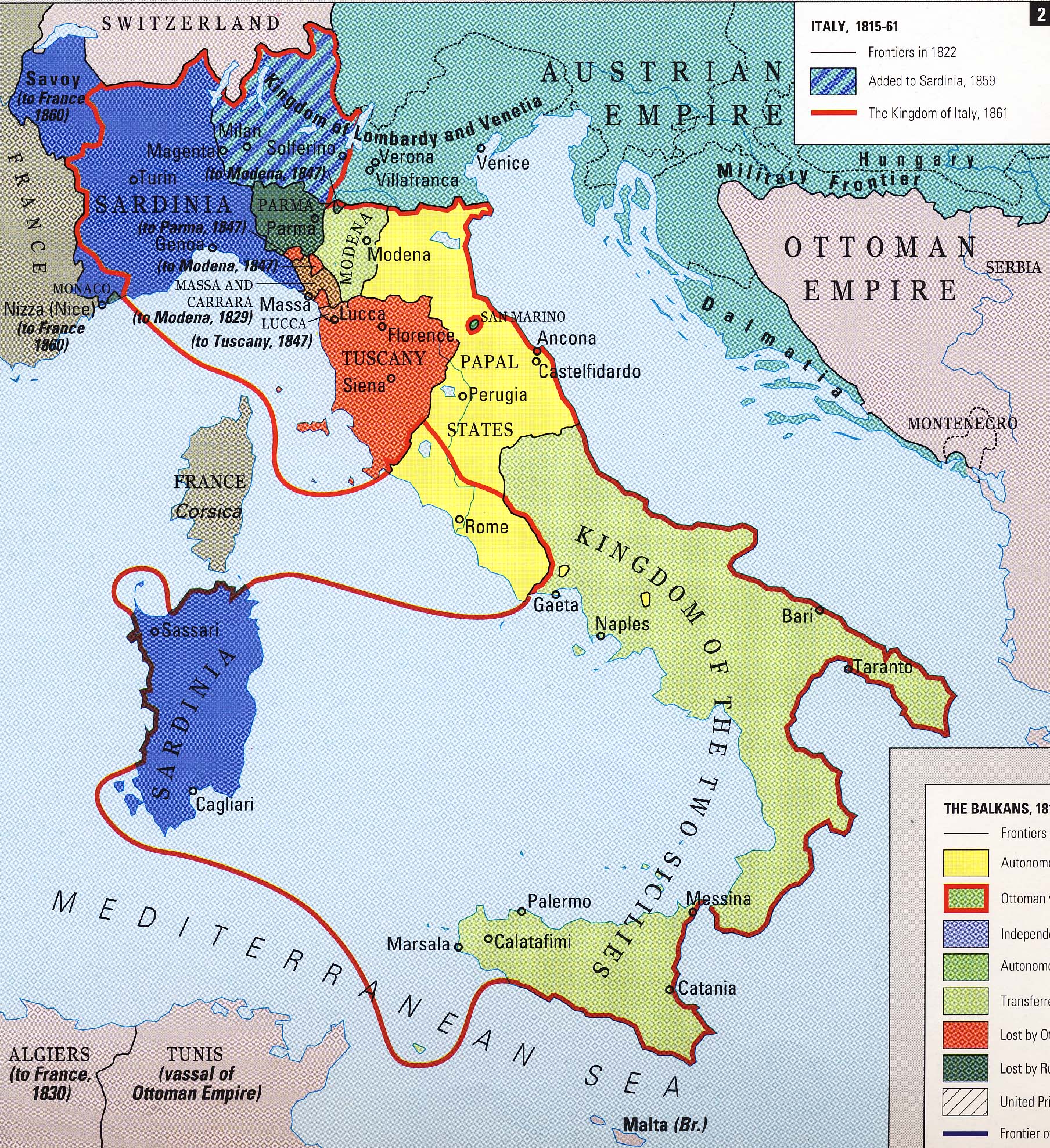
Stage section 5 as a slide bar timeline from 1815 to 1861. Use Congress of Vienna divisions from end of previous section as base map. Label and outline with a dotted line the Papal States, the Kingdom of the Two Sicilies, the Kingdom of Sardinia, the Kingdom of Lombardy and Venetia, the Duchy of Parma, and the Duchy of Modena (map 40 or map 89, section 5 frame 2). The Kingdom of Lombardy and Venetia should be green, the only colored section.
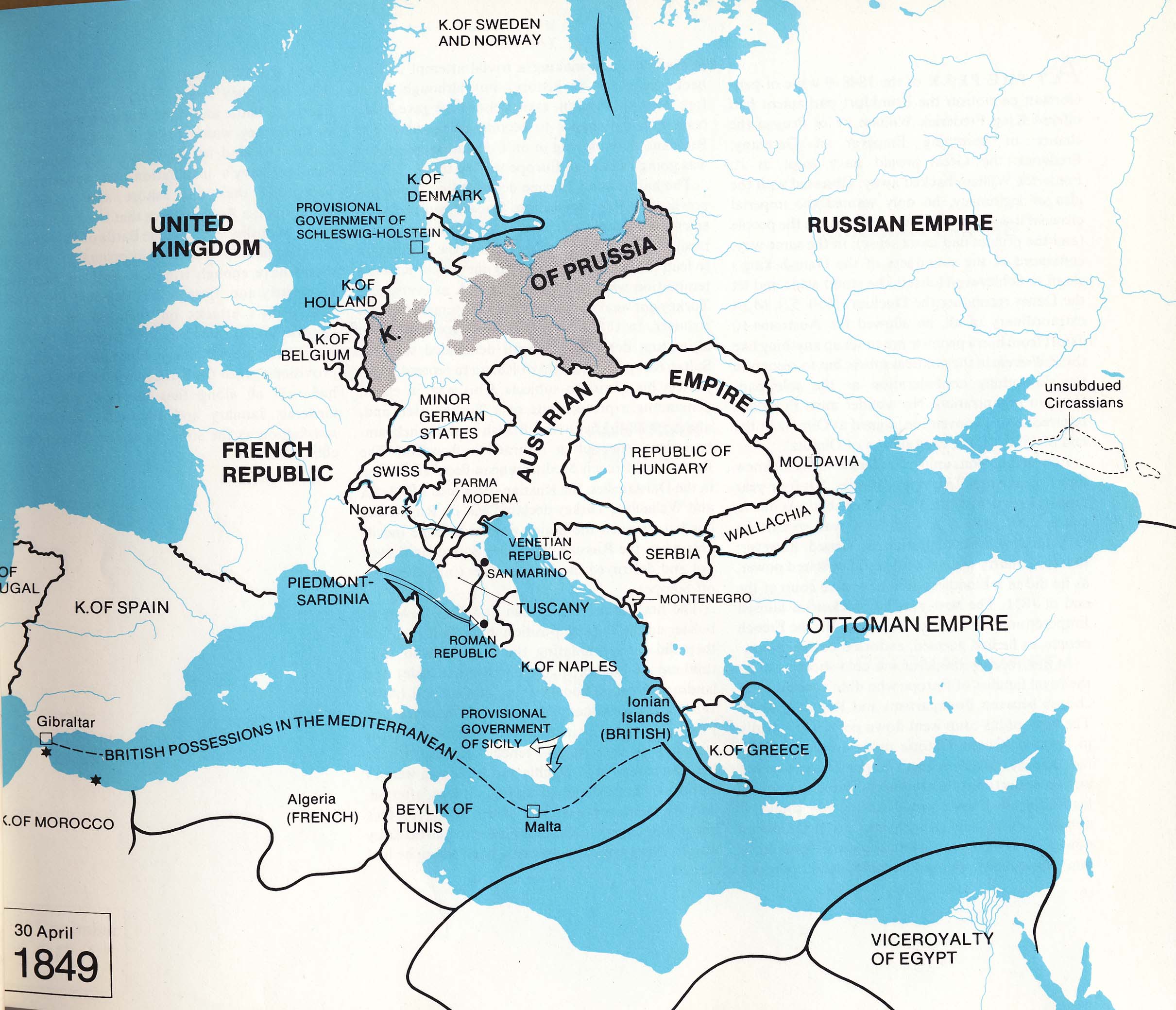
Frame 1: Risorgimento
Caption: Revolutions in Italy
Use map inventory numbers: 44, 71, 96
Frame 1 at 1848. Key should included starbursts labeled as "Areas of Unrest". Use a starburst to indicate Austria's occupation of Ferrara in 1847 (over Ferrara on map) and label with a bubble "Occupied by Austria 1847". Place starbursts in Milan, Trieste, Spoleto, Trentino, and Dalmatia to indicate unrest. Use black arrows to show French expeditionary force entering northern Italy according to map 71 (into Rome).
The
activity of the French revolutionaries in Italy had ignited a rampant
nationalism that could not be subdued by the restoration of the old
governments so the period following the Congress of Vienna was
characterized by revolution and unrest amidst the Italian states. After
a series of unsuccessful revolts halted by the Austrian troops of the
Holy Alliance, the Revolutions of 1848 to 1849 finally began the
process of uniting the Italian states under a single nation despite
their failure to remove the Austrians from Italy. |
|---|
Frame 2: War Against Austria
Caption: Italian Independence
Use map inventory numbers: 27, 39, 44, 69, 70
Frame 2 at 1859. Use map 27 to indicate the movements of Garibaldi's forces. Show battles indicated with crossed guns on 27 as crossed swords on the map. Mark areas with a circled skull on 27 as starbursts and mark boats with a ship symbol. Also show, the advance of the Sardinian army with a red arrow and Garibaldi's journey with blue. Lombardy-Venetian need no longer be green, but keep dotted outlines from previous frame. Key; crossed swords: Battle, starbursts: Counter Revolutions and Revolts, blue arrow: Movement of Garibaldi's Forces, red arrow: Advance of the Sardinian Army, ships: Neapolitan Forces, red: Kingdom of Italy, 1861. Color in those areas outlined in red in map 44 with red.
The
War of Independence against Austria began in 1859 and in 1860, Italian
military leader Giuseppe Garibaldi backed by his Thousand volunteers
successfully captured southern Italy and took the title of dictator in
the name of Victor Emmanuel II. After a series of battles, Italy
finally completed the process of political unification and the first
Italian parliament proclaimed Victor Emanuel II of Savoy king of Italy
in 1861. |
|---|
Frame 3: Unification
Caption: Additions after 1861
Use map inventory numbers: 38, 89
Frame 3 at 1924, closely following the changes in map 89. Use varying shades of red (or red line cross hatching) for areas added after 1861. One shade for those added by 1870 (Rome, Venetia), another for those possessed by 1920 (South Tyrol) and another for those after 1924 (Fiume). The rest of Italy, including Sicily and Sardinia should be solid red in this section.
Though the end of the War of Independence against Austria marked the formation of Italy as a unified nation, it was not until later in the 19th and early 20th centuries that the shape of Italy appeared as it does today. The Kingdoms of Lombardy and Venetia were added after 1866, though the connecting area known as South Tyrol was not acquired until the 1920s. Even the papacy fought unification and it was not until the Italians occupied Rome in the 1870s that the pope gave up his temporal power over the Papal States but retained his spiritual authority as head of the Catholic Church. |
|---|