I recently completed a study of Late Cenozoic deformation and sedimentation within the San Andreas fault zone along the NE margin of the Coachella Valley, in collaboration with Bernie Housen (WWU), Jim Spotila (Virginia Tech), and Michele Cooke (U. Mass). UO graduate student James McNabb worked on this project, and is now employed at ExxonMobile in Houston, TX. The following papers describe the major results and conclusions of this study.
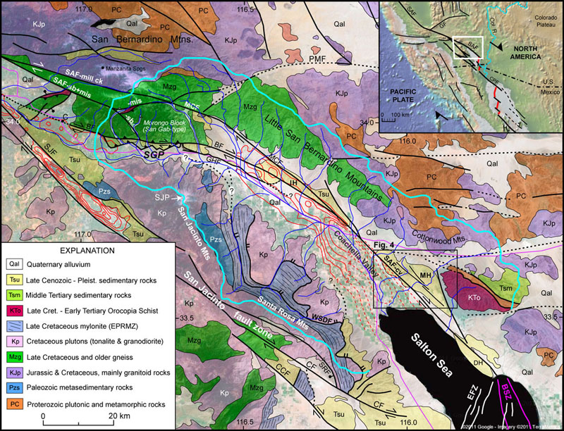
We found geologic, geomorphic, and gravity data that provide evidence for active northeastward tilting of the Santa Rosa Mountains and southern Coachella Valley about a horizontal axis oriented parallel to the San Jacinto and San Andreas faults. The Santa Rosa fault, a strand of the San Jacinto fault zone, is a large southwest-dipping normal fault on the west flank of the Santa Rosa Mountains that displays well-developed triangular facets, narrow footwall canyons, and steep hanging-wall alluvial fans. Geologic and geomorphic data reveal ongoing footwall uplift in the southern Santa Rosa Mountains, and gravity data suggest total vertical separation of ~5.0–6.5 km from the range crest to the base of the Clark Valley basin. The northeast side of the Santa Rosa Mountains has a gentler topographic gradient, large alluvial fans, no major active faults, and tilted inactive late Pleistocene fan surfaces that are deeply incised by modern upper fan channels. Sediments beneath the Coachella Valley thicken gradually northeast to a depth of ~4–5 km at an abrupt boundary at the San Andreas fault. These features all record crustal-scale tilting to the northeast that likely started when the San Jacinto fault zone initiated ca. 1.2 Ma. Tilting appears to be driven by oblique shortening and loading across a northeast-dipping southern San Andreas fault, consistent with the results of a recent boundary-element modeling study.
Systematic northeastward tilting between the San Jacinto and San Andreas faults since ca. 1.2 Ma is supported by: (1) geologic and gravity evidence for large vertical offsets on the San Jacinto and SAF zones; (2) a steep fault-controlled range front at the southwest margin of the southern Santa Rosa Mountains and large low-gradient alluvial fans on the northeast side; (3) lower ratios of fan area to catchment area (Af/Ac) in the southwest Santa Rosa Mountains compared to higher ratios on the northeast side; (4) evidence for substantial postdetachment uplift in the footwall of the Santa Rosa fault; (5) presence of tilted and incised late Pleistocene alluvial fans in the northeast Santa Rosa Mountains; and (6) progressive northeastward thickening of sediment beneath the Coachella Valley to an abrupt margin at the SAF. Northeastward tilting likely began ca. 1.2 Ma when a regional tectonic reorganization initiated the SJFZ. Processes that may drive crustal tilting include (1) oblique convergence and vertical loading across a northeast-dipping SAF in Coachella Valley; (2) dextral translation of crust through a hypothesized releasing bend in the Santa Rosa fault; (3) loading by buried mafic intrusions beneath the southern Salton Sea; and (4) short-wavelength upper mantle convection. Hypothesis 1, oblique convergence across a northeast-dipping San Andreas fault, is supported by a recent boundary-element modeling study (Fattaruso et al., 2014) and appears to be a likely driver of crustal tilting.
A few of the Publications Resulting from This Study:
| McNabb, J.C.*, Dorsey, R.J., Housen, B.A., Messe, G.T.*, and Dimitroff, C.W.* (in review) Stratigraphic record of Pliocene-Pleistocene basin evolution and deformation within the southern San Andreas fault zone, Mecca Hills, California. Submitted to Tectonophysics, July 30, 2016. | |
Fattaruso, L.A.*, Cooke, M.L., Dorsey, R.J., and Housen, B.A. (2016) Response of deformation patterns to reorganization of the southern San Andreas fault system since ca. 1.5 Ma. Tectonophysics, doi:10.1016/j.tecto.2016.05.035. |
|
Dorsey, R.J., and Langenheim, V.E. (2015) Crustal-scale tilting of the central Salton block, southern California. Geosphere, v. 11, no. 5, 19 pages, doi:10.1130/GES01167.1. |
|
Fattaruso, L.A.*, Cooke, M.L., and Dorsey, R.J. (2014) Sensitivity of uplift patterns to dip of the San Andreas fault in the Coachella Valley, CA, Geosphere, v. 10, p. 1235-1246. |
Figure 1 (above). Geologic map of the Coachella Valley region. Light blue line is the catchment boundary. Red lines are contours of sub-surface sediment thickness from Langenheim et al. (2005), dashed where inferred from Langenheim et al. (2007). Compiled from Jennings et al. (1977), Matti et al. (1992), Powell (1993), Axen & Fletcher (1998).
The southern San Andreas fault (SAF) zone in the Coachella Valley is well suited for testing hypotheses about the controls on kinematic evolution and vertical crustal motions in an active strike-slip fault system. The valley is nearly parallel to the relative plate motion and lies between a large releasing stepover to the southeast (Salton Trough) and restraining bend in the northwest (San Gorgonio Pass). Its complex structural evolution has resulted in sequential episodes of subsidence and uplift, exposing a world-class stratigraphic record of Late Cenozoic deformation, erosion, and depocenter migration due to fault zone development. Potential source areas contain unique rock lithologies and ages, catchments are accessible for new work on low-temperature thermochronology, and sedimentary rocks are superbly exposed and well suited for new dating and analysis. The unique geomorphic, geologic, and depositional setting thus allows us to study the 4D crustal evolution of a continental transform system as it responds to changes in slip obliquity, regional stresses, geometric complexities, and plate-boundary kinematics through time.

Figure 2 (above). Hypotheses to be tested in this study. A. Diagram showing oblique wrench-style deformation predicted for larger plate-motion obliquity (alpha > 20°), and strain-partitioning at margins where alpha < 20° (modified from Miller, 1998). B. Strike-slip duplexes may be transtensional or transpressional; transtension is likely to cause subsidence while transpression is expected to create uplift in the fault zone.
In addition to topical questions of vertical motions and strain partitioning, the southern San Andreas system poses a unique problem related to initiation of strike-slip faults and re-routing of plate-boundary strain. A regional tectonic reorganization is believed to have caused the end of slip on the West Salton detachment fault and initiation of the modern San Jacinto, San Felipe and Elsinore strike-slip faults at ~1.1-1.4 Ma (Morton and Matti, 1993; Matti and Morton, 1993; Lutz et al., 2006; Steely et al., 2009; Janecke et al., 2010; Dorsey et al., 2012). This event created rapid uplift in the new fault zones and transferred about half of the slip on the Coachella Valley strand of the SAF (~35 mm/yr) to the San Jacinto and San Felipe fault zones (e.g., Bennett et al., 2004; Behr et al., 2010). A tectonic reorganization of this scale should have influenced the basinal and structural evolution in Coachella Valley, yet the effects of this event on Plio-Pleistocene stratigraphy and faults in the area remain unknown and untested.

Figure 3 (above). C. Secular change at ca. 1.2 Ma is believed to have initiated the San Jacinto fault zone and widened the southern San Andreas fault system. D. Oblique view looking ~north at the southern Santa Rosa Mts, showing geomorphic evidence for hypothesized northeastward crustal tilting, which includes steep range-front topography and large recent landslide on the faulted western margin of the range. Blue lines show contours of sediment thickness in the Coachella Valley (Langenheim et al., 2005, 2007).
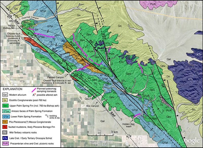
Figure 4 (above). Geologic map of the Mecca Hills, compiled from Sylvester and Smith (1976), Rymer (1991, 1994), Boley et al. (1994), and Weldon (unpubl. map data). Blue line near center shows where the contact between lower and upper members of the Palm Spring Fm is concordant and conformable (confirmed, January 2012). The Upper Palm Spring Fm (Qpu) displays abundant lateral variability that reflects local sub-basins, perhaps created during deformation that formed the angular unconformity between the lower and upper members.
 |
Left: UO graduate student James McNabb exploring a slot canyon in the Mecca Hills. James has completed a huge amount of field work in his first season on this project (winter 2012). He did lots of geologic mapping, section measuring, and collected a ton (literally!) of sand samples for detrital zircon dating. In addition, he and Bernie Housen and Bernie's M.S. student Graham Meese collected paleomagnetic samples to be used in rotation anaylsis and dating of the section.
This study seeks to fill large gaps in our understanding of the geologic evolution of the southern San Andreas fault system, a complex network of seismically active faults that define the Pacific-North America plate boundary in California. The history of deformation over geologic timescales (millions of years) is relatively poorly known, despite its critical role in shaping the crustal architecture and fault geometries that control earthquakes in this setting. Our approach benefits from a unique collaboration of academic researchers and students from four universities with earth scientists at the U.S. Geological Survey. We also are collaborating with geophysicists investigating processes of continental rupture beneath the Salton Sea, and scientists studying paleoseismology and fault slip rates on the San Andreas fault over shorter timescales. |

Above. Angular unconformity between the lower and upper members of the Palm Spring Formation, Mecca Hills. This contact can be traced to an area between the Painted Canyon and Platform faults where it is concordant and conformable (see Fig. 4, above), making it possible to establish a reliable chronology for the entire Palm Spring Formation in this area. Above the contact we have mapped and measured a thick (ca. 500 m) dipping section of upper Palm Spring Formation that records substantial subsidence NE of the Painted Canyon fault during Pleistocene time. This fault block has been uplifted rapidly since 740 ka (age of the Thermal Canyon ash, near the top of the upper Palm Spring Fm). Compilation of stratigraphic thickness and age data will be used to generate a map of uplift rates in the San Andreas fault zone over the past 740 k.y. Ultimately, the results of this study will generate new insights into dynamic linkages between 4D crustal deformation, fault-zone complexity, growth of topography, erosion, and sediment dispersal within the southern San Andreas fault system over the past ca. 2-4 million years.
Return to Dorsey's Homepage
This page was last updated October 2016, by Becky Dorsey.