A couple of sites (out of thousands) with images and stories ...
Aerial Photographs of the Damage in New Jersey - the New York Times
Mail Online (UK) - lots of aerial photos
Satellie Image Animation: growth and demise of the storm, by NASA
Scientists convicted of manslaughter for failing to warn of earthquake - the Guardian
Italian Earthquake Experts Convicted of Manslaughter - SciTech Today
Italy's Civil Protection agency: verdict will cause "paralysis" - Reuters
Italian scientists resign over L'Aquila quake verdicts - CNN
Analysis by Andrew Revkin (DOT EARTH) - New York Times
A Judgment Not against Science, but against a Failure of Science Communication - Scientific American (an alternative opinion)
What Earth Scientists are saying:
NASA's Curiosity Finds "Unusual Rock" - the BBC News story

The pyramidal shaped rock is nicknamed "Jake Matijevic", after a recently deceased mission engineer. It has a "composition not seen on the planet before". The unusual alkaline composition includes higher concentrations of Na and K than your average Mars basalt, suggesting that it might be a strange rock type called "mugearite". Its presence on Mars is potentially significant because magmas of this composition on Earth contain relatively large amounts of ... water! It seems that the NASA folks are downplaying this aspect of the find, since you have to dig to find it.
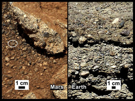
Streams Of Water Once Flowed On Mars; NASA Says Photos Prove It - the NPR story
NASA Rover Finds Old Streambed On Martian Surface - NASA's Press release, and additional striking images
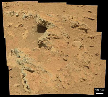
Conglomerate was deposited on an ancient alluvial fan in Gale Crater, close to Curiosity's landing site.
For Sedimentologists: This deposit is exposed at the surface as a result of a past disturbance, likely a meteorite impact. The conglomerate is quite poorly sorted and appears to have no cross-bedding that would indicate deposition from migrating gravelly bedforms. The coarse grain size, rounded clasts, and poorly sorted texture suggest rapid deposition by swiftly moving shallow water (as the NASA folks are saying), likely during floods and possibly involving debris flows or "hyperconcentrated flood flows". Note that this newest, definitive evidence for water on Mars is based on photo analysis of sedimentary textures, rounding, grain size, and sorting of exposed ancient sedimentary rocks.
Here is a direct link to the now-famous "Link" outcrop.
The Goulburn Scour is another part of this conglomerate that was blasted clean by Curiosity's rocket boosters during its descent to Mars.
|
|
Kudos to John Grotzinger and his colleagues for this exciting discovery! Grotzinger is a field geologist and stratigrapher by training. During the 1980's and '90's he conducted field studies of 1.9 billion-year-old sedimentary rocks in the remote Northwest Territories of Canada. He analyzed the composition, grain size, sorting, cross bedding, paleocurrents, etc., of sedimentary rocks, and used data collected in the field to interpret the geologic and depositional history of an ancient foreland basin. The now-famous "Link" outcrop on Mars is named after one of the Precambrian rock formations that John studied in the Northwest Territories. It is interesting to note, however, that the Link Formation is composed of fine-grained marine sandstones and mudstones, quite unlike the poorly sorted alluvial-fan conglomerate seen in the Link Outcrop. I like the name though, because it invites us to ponder an evocative "Link to a Watery Past".

Above:
the extent of Arctic sea ice on Aug. 26, 2012, the day the sea ice dipped to
its smallest extent ever recorded in more than three decades of satellite measurements.
The line on the image shows the average minimum extent from the period covering
1979-2010. Credit: NASA/JPL.
See related article in Nature: Ice loss shifts Arctic cycles - Record shrinkage confounds models and portends atmospheric and ecological change.

Larger areas of open ocean and warming surface waters will alter evaporation,
cloudiness, precipitation and storm patterns across the Arctic and beyond.
And related blog post below ...
September 10, 2012. Arctic Ice Is Disappearing and Our Weather Will Never Be The Same. "The ice area this September is 45% below the levels during September in the 1980's, and almost certainly it is at levels that haven’t been seen for a thousand years (and likely much more). The melt back this year smashed the record set back in 2007, and we have now reached a level that was actually considered nearly impossible ten years ago." Read article here.

August 2, 2012. "The balance of the carbon budget" - An article in Nature News and Views by Ingeborg Levin, summarizing results published in Nature by Ballantyne et al: "Increase in observed net carbon dioxide uptake by land and oceans during the past 50 years".

Figure 1 (above) from Levin's article shows that "Roughly half of the anthropogenic CO2 emissions caused by the burning of fossil fuels and by land-use change (such as deforestation) are currently taken up by the oceans or re-enter the terrestrial biosphere — for example, through afforestation or increased biomass production by plants. These carbon sinks have been efficiently damping increases in anthropogenic CO2 (Fig. 1), but will not necessarily continue to do so. Possible mechanisms that could result in reduced carbon uptake include changes in carbon chemistry and mixing in the oceans, and potential feedback from land ecosystems such as increased decomposition of soil organic matter caused by rising global temperatures". This is important for understanding the global carbon budget.
Return to Dorsey's Homepage