|
Project Background
In the Fall, 2006 academic term, students taking the class “PPPM 4/536: Applied Geographic Information Systems (GIS) and Social Planning” worked with residents of the Crest Drive Neighborhood to collect data in the neighborhood of interest to residents. The planning for this project began about four months prior to the term when the Chair of the neighborhood association, Kathy Saranpa, and the instructor of the course, Marc Schlossberg, met to brainstorm potential project ideas. Over the course of those four months, we eventually decided to conduct a walkability analysis of some central streets between
Crest
Drive
Elementary School
and Wayne Morse Ranch.
space |
|
Why Walkability?
Many of the roads in the neighborhood are old logging roads that have been minimally improved over the years, despite the development of housing throughout the area. To some, these roads are just fine as is; the uneven pavement and potholes create a type of traffic calming, thereby making the streets generally walkable. To others, the streets are dangerous for vehicles traveling along the roads and for pedestrians who have to walk in the streets due to the lack of sidewalks in this area. To make any improvements to the road would require that the road be brought up to current city code, which would most likely result in some widening of the portion of the existing right of way currently used for streets. Exactly how much space “improved” streets would need is a hot topic under discussion between the neighborhood and city transportation officials.
|
|
| The basic premise of this project was to document some basic characteristics of the existing street network in terms of walkability, and to identify permanent objects next to the existing roadway that would potentially need to be removed if the street gets improved. Even though many of these objects (trees, fences, mailboxes, sheds, etc.) may be in the City’s right of way, any decision about the streets that would lead to removal of these objects would be of great concern to the neighborhood. Thus, this project sought to identify these objects proactively so that discussions about street widening and its impact on neighbors’ property could be thoughtfully considered. |
|
|
space
The University-Community Partnership
In addition to teaching hard mapping skills, the University GIS course focuses on bottom-up community change, participatory uses of GIS, and how Universities can alter its traditional paradigm of treating communities as research subjects, to one where communities actually benefit from their work with University researchers/educators. In keeping with this approach, the project only went forward after the neighborhood association officially invited the class in and committed to a dialogue that ensured that the mapping project was driven by the needs and desires of community residents. With this model, students would gain skills along the way, but that the project content was driven by the neighborhood. Of course, the time and resource constraints of conducting a project within an academic quarter (10 weeks) were present, but the project moved forward in a way to work within these constraints and in the service of the neighborhood.
space
|
|
Collecting Data
During the first four weeks of the academic term, students were taught new mobile GIS technology (using a software program called ArcPad that works on Personal Digital Assistants (PDAs)) and had a chance to interact with Kathy Saranpa. Additional meetings between a neighborhood project subcommittee and the class Graduate Teaching Fellow (GTF), Krissie Killoy, led to a narrowing of the types of issues and questions that the neighborhood wanted to explore through mapping. The class then developed a data entry interface to the GIS software that would be intuitive and easy to use for anyone regardless of GIS or PDA technology (see the Data page for the instrument used).
|
|
|
|
|
|
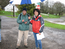
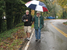
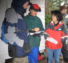
Teams of students and residents gathered on one rainy Saturday in October, 2005 to walk the neighborhood streets and collect the data using the PDAs. The day started with an hour of bagels and coffee where introductions and basic training were conducted. The teams then went out for three or so hours to collect data in different sub-sections of the neighborhood. Everyone then re-gathered at the neighborhood community center for a pizza lunch, a bit of de-briefing about the day’s data collection, and some social time to learn more about each other.
Distributing the Data
Following the data collection day, students returned to the computer lab on campus to do some post-processing of the data and three students chose to utilize the data for their final course project. These students (Heather Heater, Sara Bangen, and David Rolniak) created a master map template and in addition to making maps with the original data collected with the neighborhood residents, they also made other types of public data more public (i.e. city zoning and land use data and census data from the 2000 census). The students then created the maps available on this web site. In keeping with the participatory and community-based approach to this project, all the data collected is also available on this web site for the community to use.
All in all, this project has been very rewarding – students gained new skills and had an opportunity to apply those new skills in a “real world” setting; residents were able to outline the types of data they wanted to collect and were then able to utilize the class in service to the neighborhood; the maps produced can become resources for the neighborhood to continue the discussions about the street network and how to move forward; and perhaps equally important, the project was fun and built relationships between neighborhood residents and University students.
|
|
|
|
|