|
The Data
The community decided that for this initial project, the neighborhood
assets to be collected included the street trees within the public right
of way, the street lights, and visible dumpsters. Below is access to
this data in five formats:
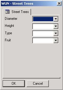
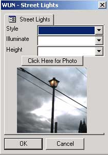
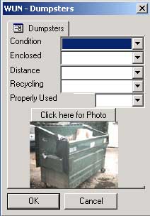
- Screen shot: this is an image of what the data entry form
looked like on the handheld computer
- Paper form: this is a copy of the paper data entry form used
by those resident-student teams that did not have the handheld GIS
technology (sample blank map)
- Raw data: this is the data for each of the three types of
community assets in Excel format. The data contains latitude and
longitude coordinates so that it can be mapped by a variety of different
software programs. Otherwise, this raw data file can be used to
calculate general summaries of the data.
- GIS files: this is the zipped up GIS files that can be used
in ArcView or ArcGIS (i.e. shape files)
- ArcPad Layer files (*.apl): this is the file that creates the
data interface on the handheld computers. It works in conjunction
with the shape files within the ArcPad mobile GIS software program.
(To save the apl file, right click on it and choose "save as...".
If you want to look at the raw code, simply click on the file.)
|