A very strong high pressure ridge with an accompanying temperature inversion had
been sitting over the Pacific Northwest for ten days and was supposed to break
down the night of Thanksgiving Day. Paul had flown in the night before, and we
decided to use the last day of nice weather to go to the mountains. I had been
contemplating Jack, but given very short days we opted for Diamond Peak, wisely
so, as it turned out.
We got going from the lower trailhead on the west side at 8:30 under cloudy skies.
After half an hour on the trail we hit snow and started skinning. Once we got high
enough on the ridge to get a view to the west it became obvious that the collapse
of the high pressure was happening about twelve hours earlier than forecast;
clearly a storm was rolling in. Somewhere between 6,500' and 7,000' the snow
became so hard that skinning was no longer effective, and we switched to snow
climbing. The crust was indeed so hard that I was wondering whether I should have
taken crampons and ice axe after all, but it was still okay without. Once we were
above tree line, Mt. Bailey got whited out, and about ten miles to the west it
was clearly raining or snowing. Shortly below the South Summit one of the squalls
we had seen coming got us, with high winds that blew the falling snow uphill.
At this point we considered out options. The main summit was still visible, but
we expected to get whited out any moment. The ridge from to the main summit did
not look skiable, and conditions were not inviting for sitting down and waiting
to see what the weather would be doing. So we ditched our packs, ran up the few
remaining feet to the south summit, then ran back down and prepared to ski. Once
we were down a few hundred feet the squall of course moved on and the weather
looked quite reasonable again.
The snow was still extremely hard, but the skiing was quite good. We stayed left
(south) of the ridge, which had little snow, and found quite good runs in a
succession of bowls. Just above tree line we stopped to have lunch and admire
the views. Then the usual survival skiing through the forest started, and pretty
soon we ran out of snow.
At this point I switched to sneakers and we worked our way down through the forest,
only to find surprisingly deep snow again farther down. Switching back to skis was
not a good option, though, due to many logs, and so we just cursed our way down,
getting pretty wet and cold feet (I due to my sneakers, Paul due to the absence
of gaiters) until we intersected the road that leads to Rockpile Trailhead. We hit
the road surprisingly far south and had to hike for almost another half an hour
before we got to the car.
On the way down Pioneer Gulch it started to rain, and the rain steadily got heavier.
At this point we were glad that we had not gone to the main summit after all, as
it would have meant hiking down the road in the dark (which would have been okay)
AND the rain (which would have sucked). We made it home with time to spare for
Thanksgiving dinner.
Pretty nice trip for late November, and the skiing was surprisingly good.
Photo Gallery:
Click the pictures to see a higher
resolution image
|
|
|
|
|
|
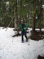
| At around 5,200' we hit snow. |
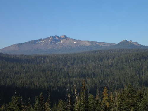
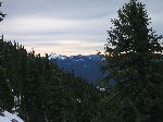
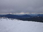
View south to Summit Lake and Cowhorn Mt. |
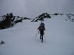
Dietrich working his way up the ridge. |
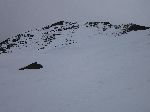
View of the windswept main summit from high on the ridge. |
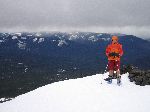
Paul on the south summit with the weather closing in. |
The first squall is approaching. |
|
|
|
|
|
|

|

|

|

|
|
|
| Dietrich starting down, ... |
and Paul following. |
After the squall moved through ... |
the weather was quite decent again for a while. |
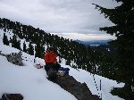
Paul brewing up. |
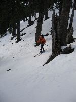
Dietrich survival skiing. |
|
|
|
|
|
|

|

|

|
| Paul showing off his flexibility. |
More survival skiing ... |
led us down to the road. |
Party: DB solo
Route: W Ridge
Equipment: Touring skis
Time: Lower trailhead - Summit : 4 hrs 45 mins
 Summit - Trailhead : 3 hrs 15 mins
Roundtrip from trailhead: 8 hrs 15 mins
Comments: Very high snow line (5,000'). Lots of rime ice and deep, wet,
unconsolidated snow. Skied off of the south summit.
Trip report:
Party: Dietrich and Paul Belitz
Route: S Slopes
Equipment: Touring skis
Time: Rockpile Traihead - Summit : 5 hrs 30 mins
Summit - Trailhead: 3 hrs
Roundtrip from Rockpile Trailhead: 8 hrs 50 mins
Comments: Snow line was at 5,600'; skiing was possible above 6,000'.
Trip report:
Party: Dietrich and Paul Belitz, Dave Cohen
Route: S Slopes
Equipment: Touring skis
Time: Rockpile Traihead - Summit : 5 hrs 30 mins
Summit - Trailhead: 3 hrs
Roundtrip from Rockpile Trailhead: 9 hrs
Comments: Snow line was at 5,000'; 15 mins walking distance to Rockpile
Trailhead.
Trip report:
Party: Dietrich and Paul Belitz, Dave Cohen
Route: W Ridge
Time: Road at 4,300' - Summit : 5 hrs 20 mins
Summit - Road: 3 hrs 30 mins
Roundtrip : 9 hrs 15 mins
Comments: Snow line was at 4,300'.
Trip report:
Party: DB and Dave Cohen
Route: W Ridge
Time: Lower Trailhead - Summit : 5 hrs
Roundtrip from lower trailhead : 7 hrs 30 mins
Comments: Snow line was at 5,200'.
Trip report:
Party: Dietrich Belitz, Dave Cohen, and Tom Tiedje
Route: S Slopes
Time: Rockpile Trailhead - Summit : 5 hrs
Summit - Trailhead : 2hrs 45 mins
Roundtrip from lower trailhead : 8 hrs 30 mins
Comments: Snow line was at the trailhead.
Trip report:
Party: DB, Thomas and Agnes Vojta
Route: S Slopes
Time: Rockpile Trailhead - Summit : 4 hrs 20 mins
Roundtrip from Rockpile Trailhead : 7 hrs 30 mins
Comments: Carried crampons and ice axe but used only ski poles.
Trip report:
Party: DB + family
Route: S Slopes up, E slopes down
Time: Marie Lake - Summit : 3 hrs 45 mins
Summit - PCT : 2 hrs
Comments: There was no snow left on the east side (bad!!).
Trip report:
Party: DB solo
Route: S Slopes up, E slopes down
Time: Marie Lake - Summit : 3 hrs
Summit - PCT : 1 hr
Comments: There was a lot of snow left on the east side.
Trip report: