Routes:
East Face (II, 5.7)
![]()
|
|
As the highest point in the contiguous fortyeight states, and thanks to a
well-maintained trail leading to the summit, Mt. Whitney is tremendously
popular. During peak season, hundreds of people summit every day.
For the technical routes that are accessible via the North Fork of Lone
Pine Creek there is a severely restrictive permit system in place. Annoying
as this can be, it guarantees a reasonable degree of solitude. The best-known
route is the East Face, an improbable line first climbed in 1931 that made it
into Roper and Steck's 50 Classic Climbs (who rated it III 5.4; most modern
parties would rate it II 5.7). The
Mountaineers Route just to the north of the east face is reported to be
quite good when snow covered, but a horrible dirt gully when it's not, in
which case its only virtue is that it provides a quick return from the summit
to Iceberg Lake. There also are several routes that climb the entire east face;
they are substantially harder and longer than the classic route that traverses
in from the right at about half-height.
On any route, the altitude makes prior acclimatization
extremely desirable. Speaking of altitude: Not that it matters, but the
14,505' elevation quoted above is the latest listed by NOAA's
National Geodetic Survey ,
superseding earlier measurements in the 14,490s.
Routes:
East Face (II, 5.7)
|
|
|
| References: Chris McNamara,
supertopo.com
|
||
Date: August 18-19, 2010
Party: Paul and Dietrich Belitz
Route: East Face
Equipment: 1.5 sets of stoppers, Camalots 0.5 - 3, 3 small tri-cams, 15 slings
Time: Whitney Portal - Iceberg Lake Lake 5 hrs 20 mins
![]() Iceberg Lake - Base of Climb 40 mins
Iceberg Lake - Base of Climb 40 mins
![]() Base of Climb - Summit 5 hrs 15 mins
Base of Climb - Summit 5 hrs 15 mins
![]() Summit - Iceberg Lake 1 hr 40 mins
Summit - Iceberg Lake 1 hr 40 mins
![]() Iceberg Lake - Whitney Portal 3 hrs 15 mins
Iceberg Lake - Whitney Portal 3 hrs 15 mins
![]() Iceberg Lake - Summit - Whitney Portal 13 hrs
Iceberg Lake - Summit - Whitney Portal 13 hrs
Trip report:
We had spent three nights at Porcupine Flats in Tuolomne Meadows, climbed Matthes Crest, and spent another night at Whitney Portal, so we figured we were well acclimatized for the East Face. The forecast was for warm weather, so we started early from Whitney Portal to avoid the heat and quickly hiked past the scenic waterfall to the Ebersbacher Ledges. They are no problem, but beware of going down this section of the trail in the dark; it may be easy third class, but the exposure is severe! Soon we arrived at Lower Boy Scout Lake, where we took a break. On the talus above the lake I got lured too high, but eventually rejoined Paul on the main trail. Soon we got to the junction just below Upper Boy Scout Lake and followed the trail around the cliff that leads to the Whitney-Russell Pass. At that point we started to feel the elevation and slowed down a bit. We still got to Iceberg Lake in a bit over five hours, set up the Betalite, and wondered what to do with the rest of the day.
Strangely, the whiffs of clouds we had seen earlier in the morning had developed into a full-blown cloud cover that was moving rapidly over Mt. Whitney. The forecast had not predicted this, and we were a bit worried. We figured it was either a weak disturbance that would blow through within a few hours, or the first front of a real storm. If the latter, the thing to do was to run up the Mountaineers Route to bag at least the summit before the weather deteriorated further; but if it was the former we'd kick ourselves the next day for having killed ourselves rather than resting. We opted for staying put, which was the right decision. After boiling water for a while (I had forgotten to take the filter) we had an early dinner and then crawled into our sleeping bags shortly after 7pm. We slept surprisingly well, woke up at 5am to perfect weather, and by 6am we were on our way. We left our sneakers at the lake; I did the approach in climbing shoes and Paul opted for his FiveFingers. There was one party of two just ahead of us on the East Face, and another party of three headed for the East Buttress, but that was it and we did not run into anyone from the start of the climb to the summit.
Paul led the Tower Traverse, which is quite impressive, then we simulclimbed the Washboard. Pitch 5 turned out to be a one-move wonder, but that one move was quite strenuous. (We went straight up; there may be an easier way farther to climber's left.) We linked Pitch 5 and the Pitch 6 downclimb into one, then moved the belay into the notch. I took on the Fresh-Air Traverse, where I promptly went a bit too high, but Paul, who had a better overview from the belay, directed me back down. The crux move is truly impressive, but very well protected (two pins before the crucial step, and one after) and really enjoyable. The remainder of the pitch to the base of the chimney is unprotectable, but easy; I thought it was not even 5.6. From the belay I could see an old piton straight below; that must have been part of the complete East Face, a route that's mentioned in 50 Classic Climbs and also listed in the book by Porcella and Burns. The views down, over to the Keeler Needle, and into the valley and to the desert ranges in the east were breathtaking. Paul led the chimney, which is mostly a straightforward stemming exercise with one awkward move about 15 feet above the belay, the we simuled Pitch 9. Pitch 10 starts with a very short 5.7 crack (protected by a pin), then goes back and forth on ledges until one can no longer avoid the corner to climber's left. Some strenuous stemming got Paul up, I followed and then took on Pitch 11, which is fun 5.6 face climbing with reasonable pro. After crossing the small talus field indicated in the topo we were not quite sure whether to unrope or not, and finally decided to stay roped and simulclimb. About 250 feet of that brought us to what looked like the base of the summit block. I was going to explore what seemed to be an exposed but easy way around the block on climber's left, but Paul insisted on finishing straight up a finger crack. It was maybe 5.7 or 5.8, and rather short, but got me winded on account of the altitude. A few more steps up some blocks, and we were on the surprisingly large summit.
As expected, there was quite a crowd excitedly talking into their cell phones, and we had to answer some questions of the sort we got used to in the Dolomites ("did you do some rock climbing up here?" being one of the more sensible ones). We still felt very good, ate some lunch, enjoyed the views, and admired the summit marmot.
After about an hour on the summit we went down to the notch that marks the top of the Mountaineers Route and is very easy to find. There was some snow and ice left in the gully, but that was easy to avoid and it was mostly really steep dirt in between sections of third and occasional fourth class downclimbing. A bit over an hour and a half of that got us back to Iceberg Lake. Paul's FiveFingers performed very well on the way down; in fact, he was quite a bit faster then I in my climbing shoes. We would have loved to take a longer break at the lake, but we figured that unless we wanted to risk getting caught on the Ledges in the dark we had better get going. So we packed up and got on our way. As usual, there was much more talus than I remembered from going up (someone must go up in the meantime and deposit that stuff!), and on the slabs below Upper Boy Scout Lake I managed to lose the trail and got my feet wet in a swamp, but we still were quite a bit faster going down than going up and passed the Ledges with plenty of daylight to spare. We arrived at the Portal just before the Grill people closed their kitchen, so the fact that we had hurried away from Iceberg Lake resulted in a real dinner, which we much appreciated. The campground at the Portal was full, so we drove down to Lone Pine Campground, which turned out to be very nice but almost as expensive as the one at the Portal. ($17 per night for parking a car and sleeping in the dirt seems a bit stiff!) The next morning we had a last glorious view of Mt. Whitney, then we drove back to San Diego.
It was a great trip, the route well deserves its classic status, and most everything worked out very smoothly. Most importantly, our acclimatization strategy worked, which helped a lot to make the route a truly enjoyable experience. The only thing that went wrong was a huge blister I developed under my right foot, which did not bother me much but would have prevented more hiking during the next few days had we planned on that. My main mistake was probably to stay in my nylon socks after my feet got wet, rather than switching into dry wool socks (which I did carry), which allowed a small hot spot that had resulted from the long hike to and from Matthes Crest to develop into a full-blown blister. Fortunately, that mistake was of no consequence.
We should go back some time and do the East Buttress, which also looks very nice!
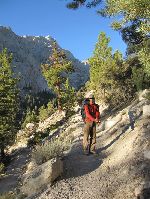
Paul on the trail. |
Dietrich on the Ebersbacher Ledges. |
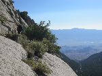
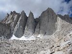
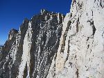
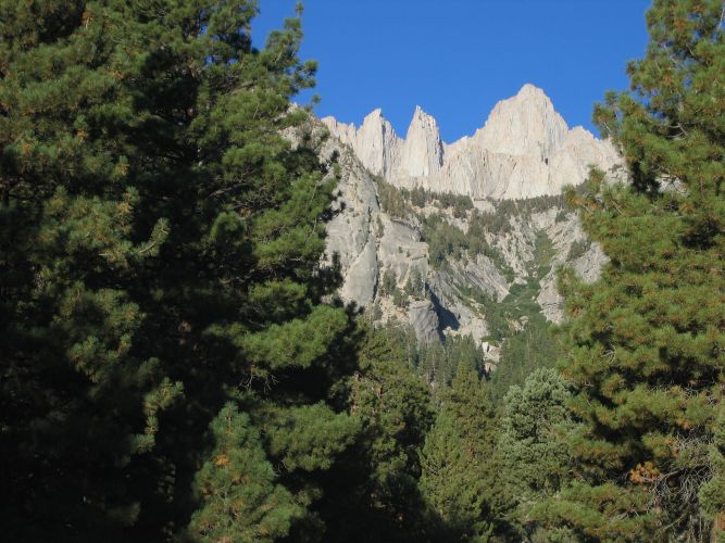
Mt. Whitney and the needles from below Lower Boyscout Lake. |
View back down on Lower Boyscout Lake. |
Our camp at Iceberg Lake. |
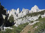
Mt. Whitney from a point near Iceberg Lake. |
||||||
Paul belaying at the top of the First Tower Traverse. |
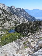
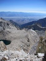
View of Iceberg Lake and the valley from the top of the Washboard. |
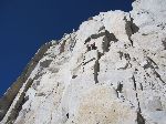
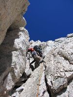
The Fresh Air Traverse from the notch. |
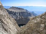
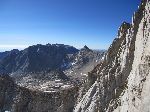
View of Mt. Langley from the notch. |
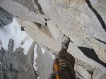
Dietrich leading the Fresh Air Traverse. |
Paul documents the fresh air while following. |
||||||
Paul starting up the chimney. |
View east from high on the route. |
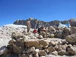
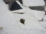
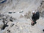
Someone had beaten us to the summit ... |
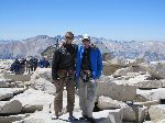
... but eventually we made it there, too. |
Paul at the top of the Mountaineers Route. |
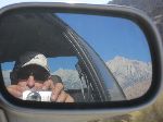
Saying goodbye to Mt. Whitney and Lone Pine Peak. |