Geography 423/523: Advanced Biogeography: Landscape Ecology
Winter 2019
Instructor: Daniel Gavin (dgavin@uoregon.edu)
Office: 110 Condon Hall; Phone: 346-5787
Office Hours: Wednesdays 3:00-4:30.
Note: Use the link above to access a free online copy of the book through the UO Libraries.
The current patterns in the natural world are strongly linked to processes occurring at a range of spatial scales, from centimeters to continents. They are also the result of a series of contingent events that have played out over time periods of days to millennia. In this class we examine the types patterning occurring across landscapes (scales of 10's to 100's of kilometer) and how they have emerged from changing disturbance regimes (fire, disease), climate, and effects of humans. The subject matter will deal mostly with biodiversity, forest vegetation, and disturbance regimes. The class will serve as an introduction to Landscape Ecology, and therefore some background in ecology or biogeography is important. Two special emphases in this class are 1) use of stochastic modeling to understand patterns of landscape structure, and 2) use of paleoecological methods to explore the question of "what is natural" with respect to changing environments of the past 500 years.
Topics covered will include:
- Introduction to concepts of scale and drivers of landscape pattern.
- Quantifying landscape pattern (spatial statistics)
- Stochastic simulation modeling, especially state-and-transition models.
- Variability (heterogeneity) of landscapes and influence on ecosystems and species interactions (e.g., invasions).
- Paleoecological methods to reconstruct landscapes of the past.
Prerequisite: GEOG 323 (Biogeography), or permission of the instructor. For permission, contact me by email and list relevant course experience including ecology.
Each week of the course will address a chapter in the textbook, with a few exceptions. Mondays will be a general lecture (but I always encourage discussion) and Wednesdays will involve addressing a few broad questions in small groups and later as a full class.
Differentiation of Geog 523 and 423: Geog 523 students will read one journal article per week and meet at a separate time to discuss this article. This time is to be determined soon.
Assignments
- Problem sets: four problem sets through the term will involve some sort of written or analysis problem related to the topic of the previous week. 40% of grade.
- Midterm exam: Several short-answer questions. End of week 4. One page of notes is allowed (to be submitted with the exam). 15% of grade.
- Final exam: Addresses the second half of the class. One page of notes is allowed. 10:15 Tuesday, March 19. 25% of grade.
- Landscape model project: Group project that will be due Wednesday of Finals Week. 20% of grade. See bottom of this page for details.
Week 1
- Topic: Introduction to landscape ecology, concepts of scale and pattern.
- Readings:
- Chapter 1.
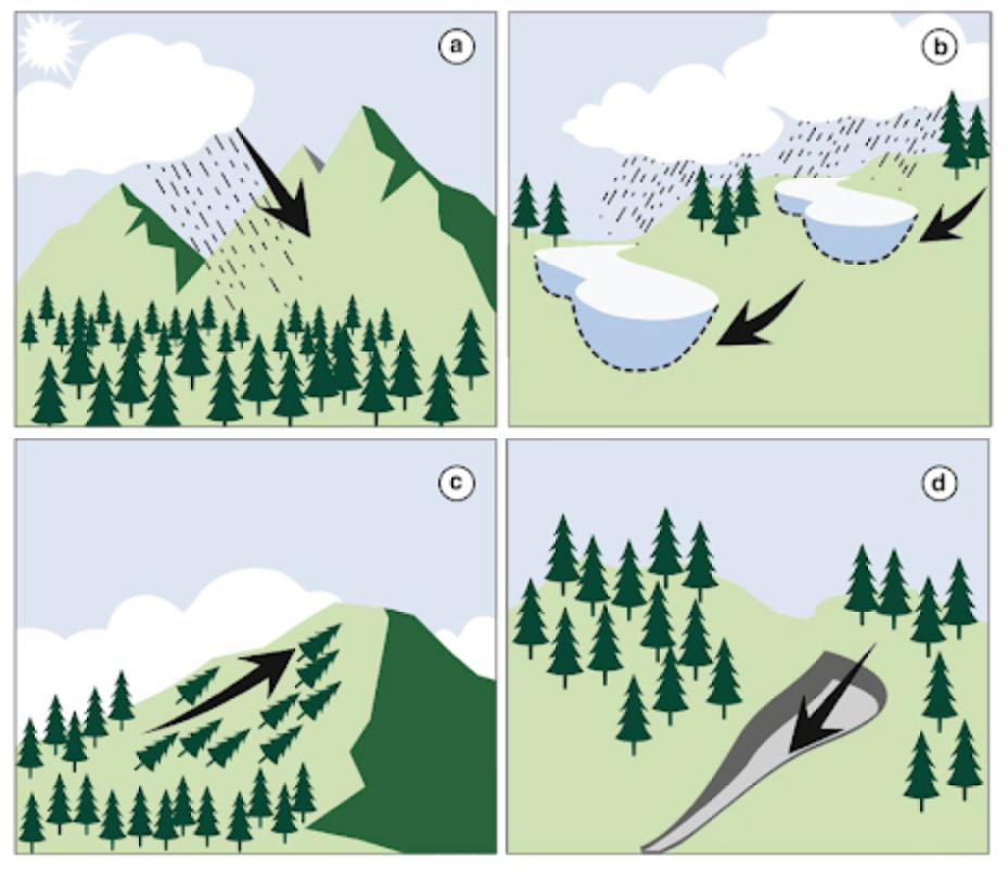
- Daubenmire, R. 1980. Mountain Topography and Vegetation Patterns. Northwest Science 54:146-152.
- Discussion topics
- Class discussion (Wed:): See questions on pages 31 and 32 of the textbook.
- A common issue in landscape ecology is to meaningfully address patterns that occur at different spatial scales. A pattern of forest vs. grassland may be evident on a map at 1-km grid cell size. But much finer patterns exist at 30-m grid cell sizes. One challenge is to downscale observations at a coarse resolution to a much finer resolution, often by using additional information at the finer resolution (such as elevation, aspect, etc). Which concepts in the Daubenmire paper have implications for the issue of downscaling? What ways might this be overcome?
- Geog 523 discussion: Schneider, D.C. Applied Scaling Theory.
Week 2
- Topic: Causes of landscape pattern
- Readings:
- Chapter 2
- Discussion topics
- See questions at end of Chapter 2.
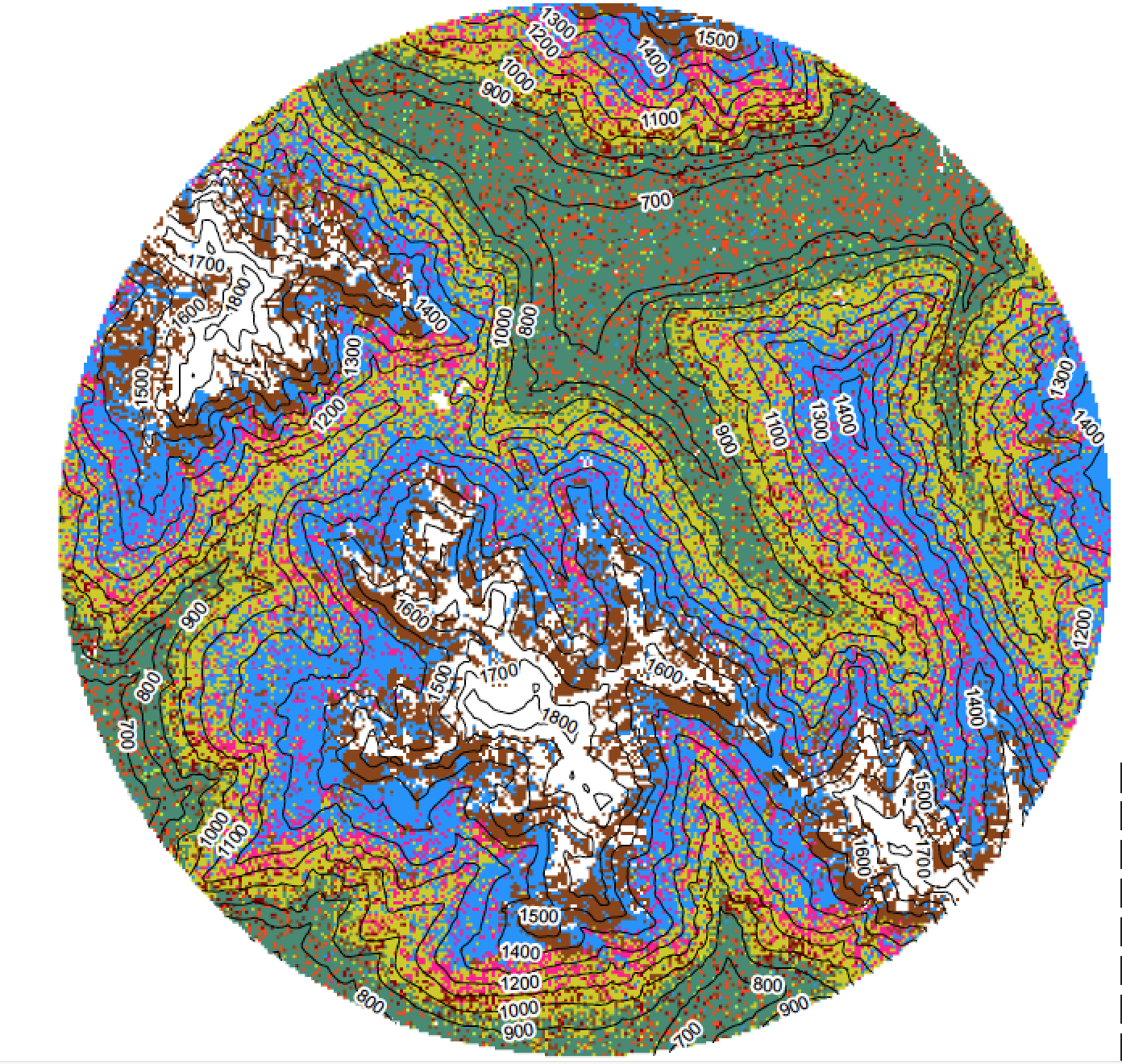
- Geog 523 discussion: Dobrowski, S. Z. 2011. A climatic basis for microrefugia: the influence of terrain on climate. Global Change Biology 17:1022–1035.
- Problem set 1: Southwest Oregon vegetation gradients.
Week 3
- Monday: no class (MLK day)
- Topic: Introduction to models
- Readings:
- Chapter 3
Week 4
- Topic: Landscape Metrics
- Readings:
- Chapter 4
- landscapemetrics introduction.
- Wednesday: Midterm exam
Week 5
- Tuesday (due date): Problem set 2: Quantify land cover change using Google Earth Engine
- First, use this tutorial as an Introduction to Google Earth Engine. Work through Part 11 (to page 35). This should demonstrate how Google Earth Engine works in general.
- Note that when copying and pasting code from the PDF file, you may need to paste one line at a time. In some cases, you may need to remove space characters in the phrase 'B4, B5, B6' to 'B4,B5,B6'.
- Then your task will be to calculate a disturbance pattern using the differenced Normalized Burn Ratio (dNBR).
- Here are the detailed instructions for the assignment..
- Topic: Spatial Statistics
- Readings:
- Chapter 5
- Discussion topics
- Using landscapemetrics
- Geog 523 discussion: Hearn, A. J., S. A. Cushman, B. Goossens, E. Macdonald, J. Ross, L. T. B. Hunter, N. K. Abram, and D. W. Macdonald. 2018. Evaluating scenarios of landscape change for Sunda clouded leopard connectivity in a human dominated landscape. Biological Conservation 222:232–240.
Week 6
- Topic: Landscape Disturbance Dynamics
- Readings:
- Chapter 6
- Discussion topics
- Introduction to iLand
- Read the abstract page (above link) and start to poke around on the wiki pages.
- Geog 523: Start to read the Ecological Modeling paper describing iLand. (I suggest downloading the PDF rather than read the html version).
- Problem set 3 (Landscapemetrics). See Canvas under 'Files'. Due Friday Feb 15th.
Week 7
- Topic: Organisms and Landscape Pattern
- Readings:
- Chapter 7
- Discussion topics
- ST-SIM demonstration.
- Geog 523 discussion: Frelich, L.E. 2002. Forest dynamics and disturbance regimes. Cambridge Studies in Ecology. Chapter 8: Forest stability over time and space.
Week 8
- Monday: Snow Day
- Wednesday: Snow Day
Week 9
- Problem set 4 (Tuesday): ST-SIM disturbance simulation.
- Topic: Reconstructing Past Landscapes
- Readings:
- Schoonmaker, P.K. 1998. Paleoecological perspectives on ecological scale.
- Discussion topics
- How do we define a 'historical baseline'. How do we quantify what it was? What is the value of it?
- How do we recontruct past landscapes?
- What lessons come from the paleo-record that are relevant to interpreting landscapes today?
Week 10
- Topic: Landscape Dynamics in a Rapidly Changing World
- Readings:
- Chapter 9
- Discussion topics
- Geog 523 discussion: Morelli, T. L., C. Daly, S. Z. Dobrowski, D. M. Dulen, J. L. Ebersole, S. T. Jackson, J. D. Lundquist, C. I. Millar, S. P. Maher, W. B. Monahan, K. R. Nydick, K. T. Redmond, S. C. Sawyer, S. Stock, and S. R. Beissinger. 2016. Managing Climate Change Refugia for Climate Adaptation. PLOS ONE 11:e0159909.
|
Final project
Basic guidelines of the project:
To meet these guidelines, the following will be needed:
30%: Idea of the experiment: explanation for the reasoning for the experiment(s) conducted. Why choose the two parameters, what might they represent in the real world? 20%: Presentation of the results of the experiments. Neatness of graphs, use of figure captions explaining content of each figure. 30%: Interpretation of the results...are the results expected from what you may have predicted? What did you learn about the model? 20%: Clarity of the writing. Addressing the implications of the results for land cover change in this region. Use of citations when required. |
Department of Geography, University of Oregon
Modified Feb 27, 2019