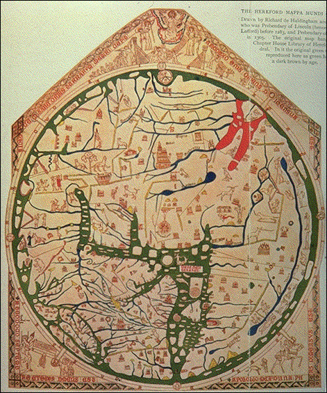
The Hereford Mappamundi
DATE: ca. 1290 A.D.
AUTHOR: Richard de Bello 
DESCRIPTION: This is the largest map of its kind to have survived in tact and in good condition from such an early period of cartography. It has been preserved in the Hereford Cathedral (England) for almost 700 years, and, besides its antiquity, it is notable for the quality of its workmanship and for the variety of the drawings which adorn it. For this map the entire entire skin of a calf had to be properly treated to make writing and coloring possible. Calfskin prepared in this manner is called vellum (from the Latin word vitulus, a calf). The vellum, measuring 1.65 X 1.35 m, is attached to a framework of oak, the actual map being set in a 1.32 m diameter circle. Although it bears no date, it is possible, from what is known of Richard's life and from a study of the map, to say that in its present form it was probably finished between 1285 and 1295. Image source: Henry Davis Consulting.
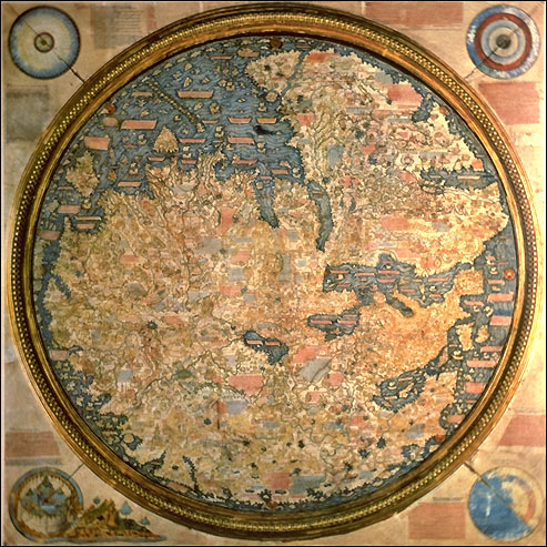

Fra Mauro's Mappamundi
DATE: 1457 -1459 
AUTHOR: Fra Mauro 
DESCRIPTION: This large circular planisphere (6 feet 4 inches in diameter), drawn on parchment and mounted on wood in a square frame, is preserved in the Biblioteca Nazionale Marciana, Venice. Unusual for medieval European maps, it is oriented with south at the top (Indian Ocean, top left; Mediterranean, right center) and so meticulously drawn and full of detail and legends that it has been described as a "medieval cosmography of no small extent, a conspectus of 15th century geographical knowledge cast in medieval form." Though the coasts are drawn in a style recalling that of the portolan charts, loxodromes and compass roses are absent, and the effect is definitely that of a mappamundi, not a nautical chart. The map was fully described and reproduced on vellum for the first time by Placido Zurla in II Mappamondo di Fra Mauro Camaldolese, published in 1806 in Venice (now in the British Library), and later by Santarem in his Atlas of 1849. Image source: Henry Davis Consulting.

EUROPA delineata et recens edita 
DATE: before 1680
AUTHOR: Nicolaas Visscher
DESCRIPTION: This copper engraving map of Europe was published either by the Dutch cartographer, Nicolaas Visscher I (1618-1679), or by his son Nicolaas II (1649-1702), and measures 43.5 by 54 cm. The copy from which this particular image was generated is bound in the Atlas van der Hagen, a private, seventeenth-century compilation of maps from around the world now housed in the Royal Library of the Netherlands, The Hague. Maps such as this often functioned as a sort of index to more detailed maps bound with it.  Image source: Atlas van der Hagen, Koninklijke Bibliotheek, Den Haag.

Return to History 102 Homepage