|
|
 |
|
|
| Data from the 64-element OBS array will be used to image the 3-D seismic structure of the crust and topmost mantle along an 80-km-long section of the Endeavour ridge. The experiment will image four targets: (1) crustal thickness variations within 25 km of the axial high (0 to 900 kyr); (2) the 2-D (i.e., map view) structure of the isotropic and anisotropic uppermost mantle beneath the spreading axis; (3) the 3-D structure of the crustal magmatic system and (4) the detailed 3-D, shallow crustal thermal structure beneath the Endeavour vent field. The results of imaging will define the recent history of magma supply, the pattern of melt delivery from the mantle to the crust and the structure and segmentation of the subseafloor magmatic and hydrothermal systems.
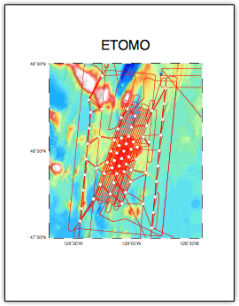
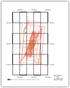
Figure to the right shows the 64 sites where OBSs were deployed (open circles) and all ship’s tracks during the experiment. The latter include OBS deployments and recoveries, seismic survey lines and multibeam bathymetric mapping.
|
|
|
|
|
|
 | The primary operational goals of ETOMO were as follows:
|
|
|
|
|
|
a. | Deploy 68 ocean bottom seismometers at 64 sites
|
|
|
|
|
|
b. | Record seismic energy from the Langseth’s 36-gun, 6600 cu. in. airgun array
|
|
|
|
|
|
c. | Recover 68 ocean bottom seismometers
|
|
|
|
|
|
d. | Produce SEGY files of all OBS data
|
|
|
|
|
|
e. | Complete post-acquisition editing of all Simrad EM122 multibeam data
|
|
|
|
|
|
f. | Archive all cruise-related data and finalize report
|
|
|
|
|
|
|
|
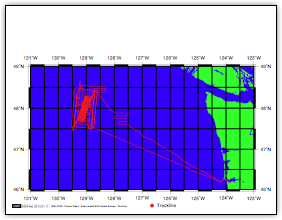
RegionalTrackLine.pdf
The complete set of track lines for MGL0910
|
|
|
|
|