Research in the geological sciences provides a wealth of data - both observational data and results from data-driven theoretical studies - that have not yet been fully utilized by professional educators (or by researchers for that matter). A primary cause for this under utilization is that the majority of the information exists either in an inert, non-interactive form (e.g. journal publications) or as unlinked and incompatible computer data or algorithms. Additionally, when considering education, few researchers have the foresight and/or resources to develop an infrastructure that would deliver their research directly to an undergraduate classroom in near real time.
The chief objective of this proposal is to develop a WEB-based environment (and software tools) that will enable instructors to make their research an integral part of the lower-level undergraduate experience. This infrastructure will be designed to help professors deliver their research (i.e., the data and analysis tools) to the classroom thereby giving undergraduate students ready access to currently active research projects in the Department of Geological Sciences. While this effort will focus on an NSF-funded research project related to the Galapagos Hotspot and Spreading-Center system, much of the ground that we break will provide other instructors/research scientists with the software tools and infrastructure necessary to establish similar educational environments for other field-going research projects.
We envision a WEB-based instructional environment that would allow students to work as teams in a self-paced manner. A successful instructional environment will enable students to analyze real data, obtain their own results, conduct numerical simulations to understand complex interactions, and facilitate the team reporting of experimental results and interpretations. This environment will also provide students with an opportunity to develop and evaluate competing hypotheses, in itself a central goal of higher education.
We present two examples of what one might do with the type of educational environment that we envision. The first case, we focus on shared data.
Example 1: Event characterization in space and time. Studies of volcanic and tectonic events often collect a time series of spatial observations. In some instances, such as a discrete magmatic eruption or a significant earthquake, the temporal and spatial evolution of an event is relatively well sampled on a scale familiar to a human observer. As a result, a student can often grasp or infer cause and effect. On longer time scales, say decades, the temporal and perhaps spatial evolution may be less obvious, though there may still be resolvable changes in observations. Detecting changes in data that span several orders of spatial or temporal magnitude challenges the limits of a student's ability to see cause and effect. Overcoming this conceptual hurdle requires an efficient means of storing, cataloging, comparing and contrasting actual data.
The ability to explore spatially and temporally variable data will facilitate lateral thinking by encouraging the discovery of relations between observable processes. Students will be given direct access to data so that they can characterize the kinematics of geologic events by integrating surface geology with the subsurface expression of active processes. For example, in our proposed environment students will be able to compare the distribution and character of Galapagos seismicity and geodetically measured surface deformation with maps of surface geology in order to understand the history of a geologic events. We anticipate that requiring students to describe and characterize the kinematics of geologic phenomena will develop their ability to carefully catalog and compare data and results, thus improving their ability to observe.
In the second case, we focus on the use of numerical experimentation as part of instruction.
Example 2: Tomographic inversion of seismic data to determine physical structure beneath volcanoes of the Galapagos. Not all science is as straightforward as comparing and contrasting raw observations. In many cases, the collection of data is followed by an intensive period of data analysis in an effort to get a "result", which can then be compared to other data, other results, or against the output of numerical simulations. In geophysics, one common example of a result is determining the seismic velocity structure of the Earths crust and mantle. The goal in this case is to use maps of anomalously low or high seismic velocities to estimate more interesting physical properties such as temperature, porosity or partial melt content. This process is filled with challenges and pitfalls. Firstly, the actual seismic data is often non-unique, inaccurate and inconsistent. The same can be said of the resulting maps of seismic velocities. Secondly, given such a result, one must infer the cause of the anomalous velocities using mapping functions between physical and seismic properties that are themselves imprecise and sometimes unknown.
For the instructor, the challenge is to convey to the students the consequences of non-unique, inaccurate, and inconsistent data or results. These concepts are not easily taught in a lecture-based format. They require that the students attain first hand experience with analyzing imperfect data. One aspect of our proposal will be to develop tools that will allow students to undertake analysis of real data to infer subsurface structure (see the section below on TIERRA).
These two examples are meant to outline how an interactive WEB-based environment could be used at the instructional level. Currently there are several impediments to such linking of observational data and numerical tools in an educational environment. Our proposal to develop the VRV-ET will constitute an initial step, providing the following:
VRV-ET will consist of a user interface that will work over the web, providing support for viewing, loading, and selecting subsets of data. It will allow students to build personal databases for off-line use, define and launch numerical experiments using a set of predefined analysis tools, and present project reports (both in traditional and web-tour formats).
VRV-ET will build on the expertise and software that we have developed for three related projects: TIERRA, ViNE and the Oman Virtual Field trip site.
TIERRA (Tomographic Imaging Environment for Ridge Research and Analysis). This research project is designing a domain-specific, environment for marine seismic tomography. The environment encapsulates existing tomography code, allowing access to high-performance computing, on-line model visualization, and the ability to interact with and control computations at runtime. TIERRA thus provides an interactive, graphical steering environment for the seismologist.
For VRV-ET: A simplified version of this system will be available to students who will analyze subsets of real data. Students will be provided with examples of "excellent", "normal", and "poor" data that they will analyze themselves, thereby gaining a deeper understanding of the meaning of data, result and interpretation.
ViNE (Virtual Notebook Environment). ViNE is a platform-independent, WEB-based interface that supports a range of scientific activities across distributed, heterogeneous computing platforms. ViNE provides scientists with an electronic version of the common paper-based lab notebook, but in addition, it provides support for collaboration and management of computational experiments. Collaboration is supported with the WEB-based approach, which makes notebook material generally accessible within a hierarchy of security mechanisms that screen that access. ViNE provides uniform, system-transparent access to data, tools, and programs throughout the scientist's computing infrastructure. Computational experiments can be launched from ViNE using a visual specification language. The scientist is freed from concerns about inter-tool connectivity, data distribution, or data management details. ViNE also provides support for dynamically linking analysis results back into the notebook content.
For VRV-ET: ViNE will be used to catalog the data and computational experiments of scientists involved in the actual field trip as well as students involved in the virtual version.
Oman Virtual Field Trip. This project is developing infrastructure needed to build and edit a set of web pages depicting a geological tour. The design of the site is based on a "scrapbook" of photos which can be organized into tours, lectures, and galleries. The tools developed for this field trip would be used by instructors to develop the skeleton of a virtual Galapagos field trip. Once a skeleton architecture is defined, students working as teams would be given the task of further developing the site.
For VRV-ET this infrastructure will be used to build a class "virtual web site" in which students organize the presentation of relevant information.
Scope of this proposal (RFP)
This proposal will provide salary support for a system's programmer capable of stabilizing/rewriting the Oman infrastructure and adapting the TIERRA code for use with a class.
Meanwhile, the proposers will collect information for the Galapagos virtual fieldtrip during an actual trip to the Galapagos and will develop a series of proposals (to be submitted S99) to the National Science Foundation, the National Geographic Society (and whoever else will listen to fund the much larger VRV-ET).
Description of Research Project: The Galapagos Experiment
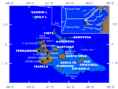
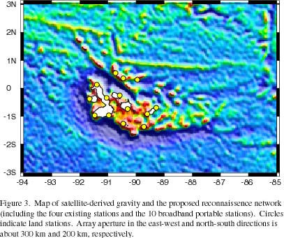
Chemical, physical and biological earth scientists are actively developing a new research theme that addresses the nature of "Hotspot-Ridge Interactions", of which the Galapagos Islands and Spreading Center system is the type example. Under discussion is a community-wide proposal to undertake a multiyear, multidisciplinary "Galapagos Experiment" to quantitatively test existing geodynamic and geochemical models of hotspot-ridge interactions, and to examine the effects of variations in magma supply at a more or less constant spreading rate on crustal accretion processes including ridge segmentation, formation of axial topography, magma chamber structure and dynamics, ridge tectonics and hydrothermal fluxes. In preparation for this new research theme, seismologists from the University of Oregon have received NSF support for a proposal entitled Seismic reconnaissance of the Galápagos Archipelago: Is there a Galápagos plume and where is it centered? This grant will allow the deployment of a broadband seismic array in the Galapagos Archipelago for one year, beginning this summer. The reconnaissance experiment will record local and regional seismic activity in order to seismically image the source of the unusual volcanism associated with the Galapagos Archipelago. The idea behind the more ambitious "Galapagos Experiment" is a COORDINATED set of SPECIFIC field programs/laboratory studies (geophysical, petrological, geological), perhaps numbering 4-6 oceanographic cruises, that would be carried out over a 3-5 year period to address some of these questions in an area which is a classic example of a hotspot-influenced ridge.
The large number of hotspot-influenced ridges today, as well as through geologic time, and the broad horizontal extent of hotspot effects which can be documented along modern systems, indicates that hotspot-ridge interactions are a fundamental process affecting crustal accretion along the global mid-ocean ridge system. Hotspot-influenced ridges provide a unique natural laboratory in which hotspot-related variations in mantle properties (e.g. upwelling rates, mantle temperature, and chemistry) affect ridge crest processes. These hotspot-imposed "perturbations" can provide fundamental new insight into a wide range of processes occurring at ridge crests, as well as the geodynamics of the upper mantle. For example, characterizing the distinctive gradients in geophysical and geochemical anomalies along/across hotspot-influenced ridges may help elucidate mantle processes such as mantle flow and rheology, source mixing, and melt migration in ways that are not possible along a more "normal" ridge system. Hotspot-related variations in mantle temperature at a more or less constant spreading rate can be used to examine the role of magma supply in influencing a wide range of crustal accretion processes including ridge segmentation, formation of axial topography, magma chamber structure and dynamics, ridge tectonics and hydrothermal fluxes.
Potential components of a "Galapagos Experiment" might include: