|
Seismicity of the Archipelago: Preliminary Results Distribution of Seismicity 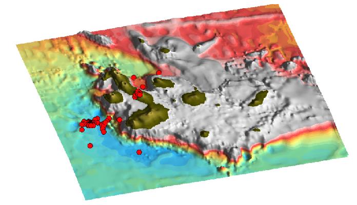 | |
Bathymetry of the Galapagos with location of earthquake epicenters between September 1999 and August 2000. The Galapagos Archipelago is a seismically active area and the seismicity appears to be associated with both tectonic faulting and the active volcanoes. The PDE catalog annually reports at least 1-2 events with magnitudes larger or equal to 4.3. Our continuous record of seismic signal, the high quality of the data, and the low levels of high frequency noise, allow the detection and location of local events with magnitudes larger than 2.0. Using data from the first year of operation of our network, we have located 56 seismic events within the archipelago. In the same period of time, the NOAA's Pacific Autonomous Hydrophone Array, that acoustically monitors the area, located 13 events (roughly those with ml>3.0), and only 2 events (Mw 5.7 and mb 4.3) were reported in the PDE catalog.
The kinds of events detected by out network include tectonic events, volcano-tectonic events and high frequency signals that could correspond to volcanic tremor or perhaps landslides. A complete spectral analysis of the data set will determine the nature of these signals, and whether or not other volcanic signals like long period events or tremor are present.
The epicentral resolution of our preliminary locations, with average horizontal errors of 6 km (compared to 17 km for the NOAA locations), permits us to correlate local seismicity with specific tectonic features or particular volcanoes. This is the case of the series of events located west of Fernandina, on the flexural moat, or the events located beneath active Alcedo volcano. For common events, our locations differ to those of NOAA's by an average of 40km, and 60km compared with the events in the PDE catalog.
|