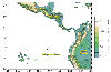
 | Topographic data compiled by: Smith, W. H. F. and D. T. Sandwell, Global Seafloor Topography from Satellite Altimetry and Ship Depth Soundings, Science, v. 277, p. 1956-1962, 26 September, 1997. |
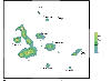 | Topographic data compiled by William Chadwick, Oregon State University. |
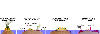 | Creation and extinction of an oceanic island. First, a volcano emerges from water, forming an island. Second, the island makes a platform which increases the diameter of the island. Third, the shore rocks crumble to form soil. Last, the island disappears leaving a barrier reef of coral, or atoll. Figure source: http://www.panda.org/kids/wildlife/mnisland.htm |
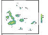 | Topographic data compiled by William Chadwick, Oregon State University. |
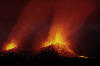 | An eruption on Cerro Azul. Picture source: http://www.geo.cornell.edu/geology/GalapagosWWW/CerroAzulEruption.jpg |
 | A variety of shield volcanoes. Piture source: http://www.rit.edu/~rhrsbi/GalapagosPages/Vulcanism3.html |
 | Basaltic eruptions are characteristic of lava fountain's and rivers decending down the nearly flat volcano flanks. Picture source: http://volcanoes.usgs.gov/Products/Pglossary/effusive.html |
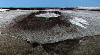
 | The long and broad caldera of Volcan Darwin is characteristic of the Galapagos Volcanoes. Picture source: http://www.geo.cornell.edu/geology/GalapagosWWW/GalapagosGeology.html |
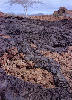 | Two types of basaltic lava, 'pahoehoe' and 'aa'. The chunky brown lava is 'aa' while the ropy black lava is 'pahoehoe'.Picture source: http://www.geo.cornell.edu/geology/GalapagosWWW/LavaTypes.html |
 | An inside view of a lava tube and a pit crater, both pictures show a collapsed top. Picture source: http://www.rit.edu/~rhrsbi/GalapagosPages/Vulcanism6.html |
 | |
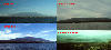
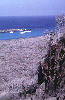
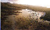 | Isla Floreana Sunset. Picture source: http://www.geo.cornell.edu/geology/GalapagosWWW/Floreana.html |
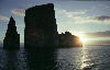 | Kicker Rock sunset. Picture source: http://www.geo.cornell.edu/geology/GalapagosWWW/Cristobal.html |
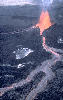
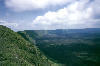
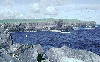
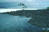 | An old lava flow that helped form Tortuga Bay. Picture source: http://www.geo.cornell.edu/geology/GalapagosWWW/SantaCruz.html |
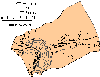
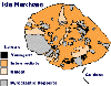 | A geological map of Isla Marchena lava ages. Figure source: http://www.geo.cornell.edu/geology/GalapagosWWW/Marchena.html |
 | The floor of Genovesa's caldera is below sea level and breaked on the south side, forming Darwin Bay. Picture source: http://www.geo.cornell.edu/geology/GalapagosWWW/Genovesa.html |
 | A picture of abingtonite found on Pinta Island. Picture source: http://www.geo.cornell.edu/geology/GalapagosWWW/Pinta.html |
 | Picture source: http://www.geo.cornell.edu/geology/GalapagosWWW/GalapagosGeology.html |
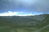
 | Isla Sierra Caldera. Picure source: http://www.geo.cornell.edu/geology/GalapagosWWW/SierraNegra.html |
 | A picture of the flat topped Fernandina. Picture source: http://www.geo.cornell.edu/geology/GalapagosWWW/Fernandina.html |
 | Ryolite on Volcan Alcedo. Picture source: http://www.geo.cornell.edu/geology/GalapagosWWW/GalapagosGeology.html |
 | A topographic map of Volcan Ecuador. Figure source:http://www.geo.cornell.edu/geology/GalapagosWWW/VEcuador.html |
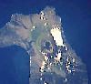 | A satelite view of Volcan Wolf. Picture source: http://www.geo.cornell.edu/geology/GalapagosWWW/VolcanWolf.jpg |
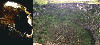
 | A view from space. Picture source: http://www.geo.cornell.edu/geology/GalapagosWWW/GalapagosGeology.html |
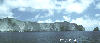
 | The South Cliffs of Isla Espanola. Picture source: http://www.geo.cornell.edu/geology/GalapagosWWW/Espanola.html |
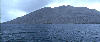
 | An ocean view from Santa Fe. Picture source: http://www.geo.cornell.edu/geology/GalapagosWWW/SantaFe.html |
 | Darwin Island and the cliffs of Wolf Island. Picture source: http://www.geo.cornell.edu/geology/GalapagosWWW/WolfDarwin.html |
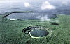
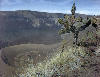 | Isla Cerro Azul's Crater. Picture source: http://www.geo.cornell.edu/geology/GalapagosWWW/GalapagosGeology.html |