Topographic data compiled by: Smith, W. H. F. and D. T. Sandwell, Global Seafloor Topography from Satellite Altimetry and Ship Depth Soundings, Science, v. 277, p. 1956-1962, 26 September, 1997. |
| Geomorphology of the Galapagos | ||
|
|
||
| Galapagos Geomorphology: A Walk Through the Islands |
| Overview |
| Geological features, such as pahoehoe lava and sunken craters, are like hidden treasures that are riddled throughout the Galapagos Islands. Many of the islands are geologically diverse, some displaying the rare mineral abingtonite. The physical characteristics of most geologic features allow for anyone to identify them in nature. Within these pages of text, each of the island?s geologic features will be highlighted and discussed. The following interpretive guide will tell you how to identify these features in the field and also educate you on the time and event of formation. Primary Authors: Bill White and Bree Burdick Edited By: Emilie Hooft-Toomey and Douglas R. Toomey |
| Geomorpholgy |
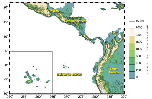
| Regional Setting of the Galapagos Islands |
|
The Galapagos Islands are located on the equator (in the Pacific Ocean), six hundred miles (1000 km) due west of Ecuador. These oceanic islands are of volcanic origin and have been building for the past four to five million years. The volcanic history of the Galapagos hot spot can be traced by the two adjacent submarine ridges, the Cocos and Carnegie ridges. The Cocos ridge extends from the Galapagos Islands, to the northeast and subducts beneath Costa Rica. The Carnegie ridge extends from the islands, to the east and subducts beneath Ecuador. Each ridge is abruptly cut off from the Central and South American mainland by the Peru-Chile trench. |
| Local Setting of the Galapagos Islands |
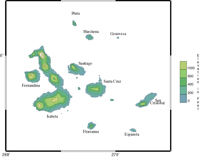
|
The Galapagos Islands, including all of it's nineteen islands and more than forty-two islets (surfacing rocks), have a total land surface of about 8000 square kilometers. Isabela is the largest island of the group, covering 4,588 square kilometers. Volcan Wolf is the highest point in the islands, standing 1707 meters and located on Isabela Island. All of the Galapagos Island's formed due to volcanic eruptions. Out of these islands there are 21 emergent volcanoes of which thirteen are considered active (White, et. al., 1993). These volcanoes do not form a linear chain, unlike the Hawaiian Islands. However, the oldest volcanoes tend to be located in the southeastern area of the archipelago. The islands, stretching over a 174-mile (320-km) diameter, encompass 50,000 square kilometers of ocean surface. The islands are perched atop an oceanic plateau called the Galapagos Platform. The platform creates a relatively shallow water depth of 360 to 900 meters (between 200 to 500 fathoms). |
| Oceanic Islands |
|
Volcanic islands, such as Hawaii and the Galapagos are composed of oceanic island basalt (OIB) formed over a mantle plume by material erupted from inside the earth. These islands are usually characterized by forming in the middle of a tectonic plate, instead of forming along plate boundaries. The origin of oceanic islands is theorized to be from deep within the mantle, due to their small, but significant levels of some elements, such as, sodium, potassium, and aluminum that is depleted elsewhere (Chernicoff, 1995). Another kind of basalt, called mid-ocean ridge basalt (MORB), is erupted at great depths on the bottom of the ocean floor. |
| Age of the Galapagos Islands (In Million Years) |

|
The oldest islands in the Galapagos are South Plaza of 4.2 million years (+/- 1.8) and Espanola of 3.2 million years (+/- 0.2). These dates correspond to when the island first surfaced above sea level. The submerged island bases could be up to fifteen million years old, Miocene geologic time. Dating all of the islands is possible by using a method called potassium-argon age dating, which dates the age of volcanic rocks (basalt's). The age dates of the other islands are as follows: Santa Fe is 2.7 million years (+/- 0.1); San Cristobal is 2.4 - 4 million years; Balta, Floreana, Pinzon, Rabida, Santa Cruz, and Wolf are all 0.7 - 1.5 million years; and Darwin, Fernandina, Genovesa, Isabela, Marchena, and Santiago and all 0.7 million years. The Galapagos Islands are relatively young in comparison to other oceanic islands making them they are one of the most active oceanic volcanoes in the world. The Hawaiian archipelago is a textbook example of a hotspot-island chain. The progression of the island chain is clearly linear to the northwest starting from the main island of Hawaii. Eventually the islands disappear underwater as part of the Emperor Seamount Chain. The youngest and most active island is Hawaii consisting of rocks younger than .7 million years. Following the island chain NW, the last emerged island of Kauai has been dated at roughly 4.5-5.5 million years (Carr et. al., 1980). Migrating further the bend Northward of the Emperor Seamount Chain has been dated at 43 ma, and the northernmost seamount has been estimated at 65 ma. Thus the youngest Hawaiian volcanoes are islands, but the older ones are now seamounts, the tops of which become progressively deeper to the northwest. Many of the seamounts, however, were once islands. Since the Carnegie and Cocos Ridges disappear into subduction zones, it is uncertain how old the Galapagos mantle plume is. A 1990 oceanographic expedition, however, did locate an 8 million-year-old seamount on the Carnegie Ridge that was certainly once an island. This volcano, though now 1500 m beneath sealevel, has rounded cobbles on a flat top, which provide clear evidence of wave erosion. Thus there have been islands in the Galapagos for at least 8 million years. The plume, however, is certainly even older. Many scientists believe that the Galapagos mantle plume is responsible for the abundant volcanic rocks of Cretaceous age that occur in the Caribbean and on the northwest margin of South America. Thus the Galapagos mantle plume could be as old as 90 million years and there may have been islands in this locality this long. This is of great importance in understanding the origin and evolution of the unique animals that occur on the Galapagos. |
| Volcanism in the Galapagos Islands |
| Galapagos Eruption's |
|
Historic eruptions have occurred on many of the Galapagos volcanoes, including Fernandina, Volcan Wolf, Alcedo, Sierra Negra, Cerro Azul, Santiago, Pinta, Floreana, and Marchena. Eruptions in the recent geologic past (the last ten thousand years or so) have also occurred on Volcan Darwin, Volcan Ecuador, Genovesa, San Cristobal, and Santa Cruz. A number of submarine volcanoes many have also been active in this time. It is quite unusual for a mantle plume to produce so many simultaneous active volcanoes. In Hawaii, for example, only 6 volcanoes (including the seamount Loihi) have erupted in this same time, and most of the activity in Hawaii is located on just 3 volcanoes). In Reunion, only a single volcano has been active. It should be noted, however, that the magma output of Mauna Loa, the largest of the Hawaiian volcanoes, has probably exceeded the output of all the Galapagos volcanoes combined. The islands of Espanola and Santa Fe are remnants of extinct volcanoes. In both cases, only part of the volcanic structure has been preserved, the remaining parts having been faulted away. Espanola and Santa Fe have been extinct for several million years. Pinzon and Rabida are both small extinct shield volcanoes that have not been active for about 1 million years. Though Santa Cruz and San Cristobal remain active volcanoes, parts of their edifices are much older, more than a million years in the case of Santa Cruz (including its small neighbors of Baltra, Seymour and Las Plazas), and nearly two and a half million years in the case of San Cristobal. |
| Basaltic Shield Volcanoes |
|
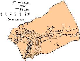
Two distinct types of volcanoes occur in the Galapagos. The difference between these two volcanic morphologies appears to be due to the difference in lithosphere thickness. The fracture zone at 91° W separates oceanic crust and lithosphere of distinctly different age. West of the fracture zone at 91°W, the lithosphere is older and thicker, and therefore able to support the load imposed on it by a large volcano. East of the fracture zone, the lithosphere is too young and weak to support large volcanic edifices. The Hawaiian volcanoes, which are the largest on Earth and much larger than the largest of the Galapagos volcanoes, are located on very thick lithosphere. In the west, on the islands of Isabela and Fernandina, the volcanoes are described as having an "inverted soup-bowl" morphology and deep calderas. The "inverted soup-bowl" morphology of the large western volcanoes is quite unusual (though not entirely unique) and its origin is not entirely certain. According to one theory, this morphology results from way in which eruptive vents are distributed on the volcanoes. Most of the vents occur either on circumferential fissures near the flat summits, or on radial fissures on the lower flanks and aprons of the volcanoes. Relatively few vents occur on the steep upper flanks of the volcanoes. Thus the volcano grows outward at the bottom and upward at the top, resulting in this distinctive morphology. The location of vents and fissures primarily reflects the stresses within the volcano. Why stresses in Galapagos volcanoes should differ from those of other volcanoes and lead to this distribution of vents remains unclear. An alternative hypothesis for the morphology of Galapagos volcanoes is that it reflects the pattern of intrusion of magma within the volcano. In essence, magma intruded into the volcano inflates the central part, pushing the summit region upward and steepening the slopes on the upper flanks. |
| Basaltic Eruptions |
|
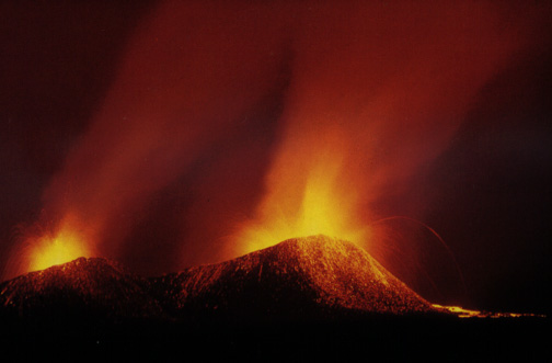
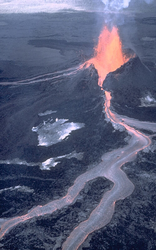
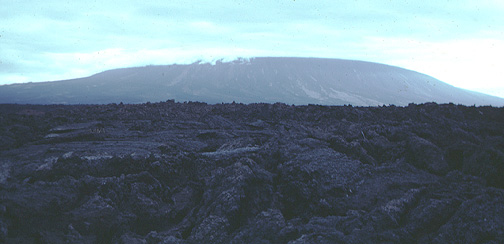
The Galapagos volcanoes are shield volcanoes, characterized by their basaltic eruptions. Their eruptions tend to be mildly peaceful because they get their fluid from basaltic magma derived from the mantle. These mild eruptions can be described as lava fountains that are high arching sprays caused by escaping gas that can reach heights of 400 meters. The sound of lava flowing down the sides of the mountain is unmistakable and has been described as crackling. A shield volcano typically has a slope of less then five degrees and is formed over time from thousands of flat, fluid-like eruptions. |
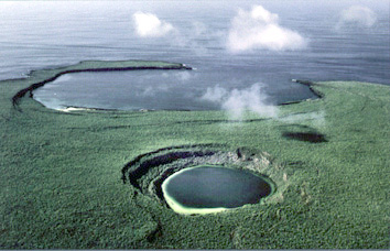
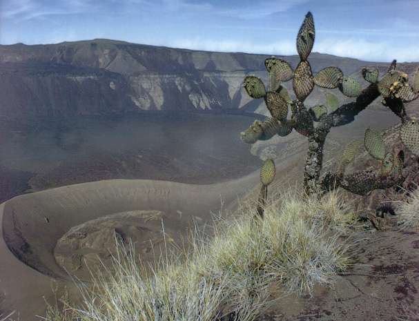
| Galapagos Caldera's |

|
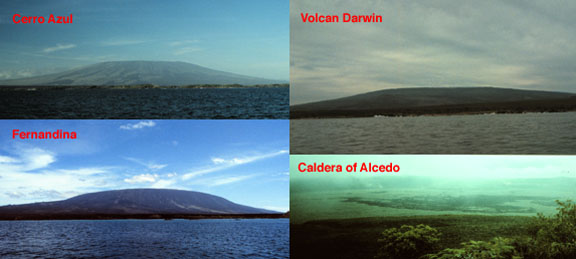
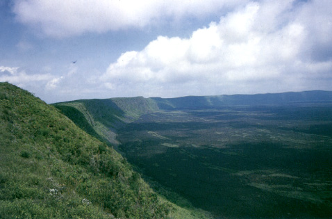
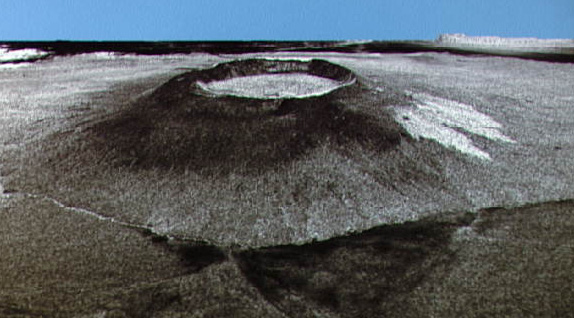
Another unusual characteristic of the western Galapagos volcanoes is the large size of their calderas, particularly in comparison to the size of the volcano. The presence of a caldera is responsible for the volcano's flat top. A caldera forms after large amounts of lava is ejected causing the volcano to collapse, due to lack of internal support from the now nearly or partially empty magma chamber. The Galapagos Islands are a good example of active, aging volcanoes because of their large calderas that illustrate a long succession of crater collapses. The most recent example of caldera collapse was in 1968 when the Fernandina volcano erupted explosively. The northern part of the 800-meter-deep caldera floor dropped an additional 350 meters. Sierra Negra, the oldest caldera of Isabela Island is 10 kilometers in diameter, while Fernandina, the youngest caldera in the Galapagos Islands has a diameter of 6.5 kilometers. Almost certainly, none of the calderas formed in a single event; instead they are the result of numerous episodes of collapse, as is evidenced by the uneven floors of some and benches on the walls of others. Once formed, caldera may boarden as parts of caldera wall collapse. This occured on Fernandina in 1988. Calderas may also occasionally fill entirely with lava, then reform. Marchena, in the northeast, has a caldera that has been very nearly filled with lava. The floor of Genovesa's caldera is below sea level and breached on the south sid, forming Darwin Bay. |
| Aa and Pahoehoe Lava |
|
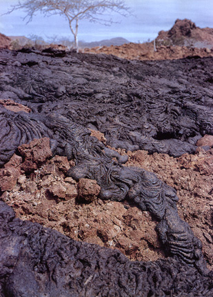
Arial volcanoes around the world are separated into four categories that depend on the type of material erupted. The most explosive (Volcanian) type emits primarily gases. The less explosive (Domean) type ejects viscous, or sticky, magma and acid. The loud (Hawaiian) type ejects magma that is fluid and basic, such as basaltic lava. This is the case of the Galapagos Islands. The mixed (Strobolian) type ejects a combination of gases, liquids and solid materials. The Galapagos Islands is a host to both basalt and, less commonly, rhyolitic rocks. Basalt is a fine-grained, dark brown to black rock that lava solidifies into. It is made of minerals, such as, calcium-rich plagioclase, pyroxene, and lesser amounts of olivine. Basalt is the main type of rock in oceanic environments, such as mid-ocean ridges and hot spots. Lava is molten material that emits from a volcano during an eruption. Flow speed depends on the viscosity of a flow. Viscosity is a fluid's resistance to flow. If the lava has high viscosity, it will act as a ductile, slow moving mass. Lavas with high viscosity tend to be more explosive because gases can not easily escape from the rising magma. If the lava has low viscosity then the molten material will act fluidly and flow fast down the volcano flanks. As lava travels down the volcano sides, the surface of the flow will cool much more rapidly. The surface of the flow forms two different types called 'aa' and 'pahoehoe'. Aa lava (pronounced ah-ah) has a rough, jagged surface due to the gas explosions tearing apart the external crust. It looks like a pile of blocks and rock fragments but underneath lies molten lava. As the lava flow advances it is churned and folded over itself, allowing gas to escape. The other kind of basaltic flow is pahoehoe (pronounced pa-hoy-hoy). Pahoehoe and aa have the same chemical composition although pahoehoe is less viscous (more fluid) then aa because the gases have yet to escape. Pahoehoe lava flow's have smooth, ropy surfaces. Underneath the surface skin is hot molten lava, pushing forward, wrinkling the skin further and producing a more ropelike appearance. Commonly you will see aa at the front of the lava flow while pahoehoe is within the flow. |
| Lava Tube and Pit Crater |
|
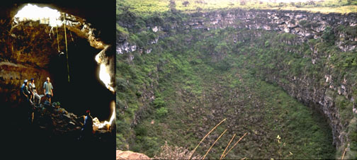
Lava tubes form when the top layer of a flow solidifies while underneath the lava still flows downhill quickly. The lava flow will eventually form a tube like structure that are usually five to six meters wide and up to ten meters in height. Once the lava runs dry a huge, hallow tube underground is all that is left. Lava tubes can be seen on Puerto Ayora and Bellavista, on Santa Cruz Island. |
| Pillow Lava |
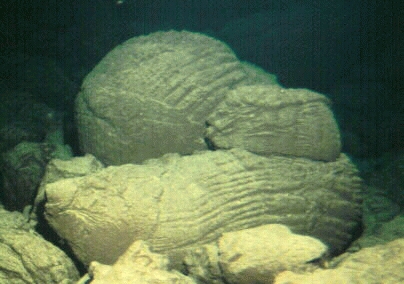 |
Rhyolite is very rare in an oceanic environment like the Galapagos, but it is not unheard of. The major difference between the two rocks is that rhyolite has a much higher silica content. It is generally lighter in color and has larger crystals. Rhyolite is generally confined to continental crust and is produced during the most violent eruptions. Tephra is pyroclastic material that cool and solidify while being projected into the air. Pyroclastic materials are defined by many different sizes, ranging from bombs to gray-white pumice pieces to ashes. An example of this can be seen on Alcedo volcano, Isabela Island. Another type of volcanic projectile is scoriae, pieces of shapeless, fluid magma. Fumeroles are volcanic gas emissions that escape into the atmosphere. Fumeroles can last anywhere from a week to any number of decades, depending on the longevity of the heat source. They can occur in groups or alone, in the shape of a vent or fissure, or even within a lava or pyroclastic flow. Fumeroles are very important during eruptions because the rising gas helps push the magma out of the conduit. Submarine volcanoes, like the early formation of the Galapagos Islands, eject magma that reacts violently with the cold water. The ejected material either forms volcanic tuffs or hyaloclastites. Submarine volcanic tuffs, or guyots, are formed by volcanic fragments, ranging in size from dust to massive blocks, that have consolidated and cemented together. Hyaloclastites is a Greek word meaning 'broken pieces of glass'. At deeper submarine volcanoes the eruptions are less explosive. When the slope is gentle, lava flows form jointed blocks with a polygonal structure. When the slope is steep, the lava flow breaks apart and forms 'pillow lava', or lava cushions. |
| Description of the Galapagos Islands |
| Isla Floreana |

|
Floreana, also known as Charles or Santa Maria Island, is the southeasternmost island in the archipelago. It is one of the smaller of the major islands, measuing approximately 12 by 15 km and rising to an elevation of 640 m (2000 feet). The oldest lavas on Floreana are 1.5 million years old, making it one of the older islands. At the other extreme, Captain Porter of the U.S.S. Essex reported witnessing an eruption in the center of the island in July, 1813. Though the products of this eruption have not been identified, there are a number of young flows and the island is covered with many young pyroclastic cones (pyroclastic cones are produced when lava it thrown into the air explosively), particularly in the highlands. All of these observations testify that Floreana remains an active volcano. Floreana represents one extreme of the range of lava compositions encountered on the islands. Basalts here are distinctly more "alkalic" in composition, as opposed to the more "tholeiitic" compositions produced by most volcanoes. "Alkalic" magmas are often richer in water and CO2, gases that drive explosive eruptions. Thus the compositional difference probably accounts for the abundance of pyroclastic cones. Trace element abundances in these lavas indicate that Floreana magmas are produced at shallower depth in the mantle and by smaller extents of melting than in the rest of the archipelago. This may well reflect its position on the southern periphery of the archipelago, where the the Galapagos Mantle Plume is cooled by contact with surrounding mantle. Floreana is one of the few islands with a reliable supply of fresh water, an artisian spring at the base of Cerro Olympus in the lush southeast highlands. Because of this, it has a long history of colonization, the first settler being an Irish seaman stranded on the island in the early nineteenth century. Among the more recent colonists was the Wittmer family, who settled there in 1932. Frau Wittmer, now in her ninties, still lives there with some of her childern, grandchildren, and great-grandchildern. A bizarre series of unexplained deaths occurred around that time, and are described in Frau Wittmer's excellent book Postlagernd Floreana (the English translation is titled simply Floreana). The book takes its name from the Post Office Barrel established on Post Office Bay in 1894 by Captain James Colnett, who was on a exploration voyage for the British Admiralty. Whalers could leave mail in the barrel to be picked up by other ships returning to port. This "Post-Office" may still be seen today. The long history of settlement has adversely affected the native flora and fauna. The Floreana race of giant tortoises was extinct by 1846. However, flamingos may still be seen in Flamingo Bay (above) and sea turtles may be seen nesting on the beach near Cormorant Point. |
| Isla San Cristobal |
|
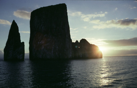
San Cristobal, also known as Chatham, is the easternmost island in the Galpagos. It is the site of the only permanent stream in the archipelago and is also where Darwin first went ashore in 1835. San Cristobal is also the site of the oldest surviving settlement in the Galapagos, El Progresso, established in 1869. It has since been overshadowed by a second town, Puerto Baquerizo Moreno, located on the southeast coast. This is one of two points of departure for tour boats operating in the islands and nearly half the islands' 50,000 annual tourists pass through its airport, which has operatied since the mid-1980s. San Cristobal island is made up of two coalesced volcanoes. The southwestern half is a symmetric shield volcano made up of gently-dipping lavas and capped by a thick, deeply-weathered pyroclastic blanket and numerous satellite cinder cones. The southwestern shield became emergent around 2.4 million years ago; activity continued up to about 650,000 years ago. The northeastern half of the island is a more recently active volcano, dominated by eruptions from NE-trending fissures. The most recent flows are no more than a few centuries old. Like its neighbors, Santa Cruz and Santa Fe, it lavas show very considerable chemical variation, with some being similar to basalts erupted at mid-ocean ridges (this kind of basalt is often called MORB ? for Mid-Ocean Ridge Basalt). In stark contrast to Hawaiian volcanoes, there is no clear petrologic evolutionary trend displayed by San Cristobal lavas. Of interest to tourists is Kicker Rock, a spectacular rock formation off the northwest coast. Kicker Rock is a remnant of a pyroclastic, or palagonite, cone, i.e., the site of a volcanic eruption that became explosive when lava and seawater mixed. Tens of thousands of years of wind and waves have carved this once conical island into the structure we see today. |
| Isla Santa Cruz |
|
Santa Cruz, also called Indefatigable Island, is located in the center of the Galapagos archipelago. It also the center of human activity in the Galapagos, since the National Park Headquarters, the Darwin Research Station, and the largest settlement in the Galapagos, Puerto Ayora, are all located on Academy Bay on the south side of the island. The main airport, originally an air base built by the US Navy during WW II, is located on Baltra, a small, low island separated from the northwest corner of Santa Cruz by the narrow Itabaca Channel. Santa Cruz is the only island having a road that crosses its interior (running from Puerto Ayora in the south to the Itabaca Channel crossing in the north), thus providing tourists a rare opportunity to see the interior and higher elevations of a Galapagos island. Santa Cruz is a shield volcano, slightly elongate in an east-west direction. A line of young cinder cones marks the crest of the island, running east southeast to west-northwest and reaching an elevation of 950 m at Cerro Crocker. This crest divides the dry leeward northern half of the island from the wetter, more heavily vegetated windward southern part. Two distinct periods of volcanic activity are apparent on Santa Cruz. The earlier period produced the "Platform" lava series, which may be seen in the northeast and on the neighboring small islands of Baltra, Seymour, and Las Plazas, small islets just off the northeast coast. They are flat-lying or gently dipping lavas interbedded with shallow marine sediments and limestones ranging in age from about 1 million years to as old as 2.3 million years. Some of these have a pillow morphology, a characteristic of submarine eruption. These lavas thus record a period of volcanic growth, subsidence, and subsequent uplift. At least some of these lavas were erupted from vents in the northwest; the vents of others may be buried beneath the central highlands. The period that produced the younger "Shield Series"lavas that consistute the bulk of the volcanic edifice began perhaps 700,000 years or so ago. With time, volcanism became focused along a ESE-WNW fissure system that now defines the crest of the island. Judging from the lack of soil between flows exposed in pit craters at the summit, development of this ediface must have been quite rapid. The youngest lavas are located in the northwestern corner of the island. These pahoehoe flows are completely unvegetated and are probably no more than a few thousand years old. Thus Santa Cruz should be considered an active, though dormant, volcano. The chemistry of the shield series lavas differs subtly from that of the platform series, perhaps due to the change in the volcano's location relative to the plume over time as it drifts slowly eastward on the Nasca Plate. Fairly recently, in a geologic sense at least, Santa Cruz has been cut by east-west faults that have produced a number of graben structures. A graben is a down-dropped block bound by faults. This kind of structure is characteristic of extentional deformation of the crust. The Itabaca Channel, which separates Baltra from Santa Cruz, is one clear example of a graben. Academy Bay, on the south coast, is another fine example, as is Tortuga Bay. A wonderful white sand beach is located at Tortuga Bay, about a 40 minute walk from Puerto Ayora. The path crosses the dramatic fault that bounds the Academy Bay graben on the south side. Similar east-west faults may be found on the islands of Santa Fe and Espanola. |
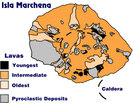
| Isla Marchena |
|
Marchena, also known as Bindloe is a large shield volcano, of which only the upper 343 m (100 feet) is above sealevel. The island measures about 18 by 12 km and is one of the three small islands in the northern group (Pinta, Marchena, and Genovesa). While Marchena and Genovesa lavas are somewhat similar in composition, both having compositions close to that of mid-ocean ridge basalts, the composition of Pinta are quite different. The many young flows and pyroclastic cones on Marchena testify to considerable volcanic activity in the recent geologic past. However, there is only one known historic eruption, which occurred in 1992. Like many of the Galapagos volcanos, Marchena has a caldera. Marchena's caldera is roughly elliptical and measures 7 km by 6 km, within the range of caldera sizes of the large western volcanoes. Marchena's caldera is unusual, however, in that it has been almost completely filled with young lavas, some of which has spilled over and down the sides. The oldest lavas are 500,000 years old. Marchena is rather desolate and has no fresh water and hence has never been settled, and its flora and fauna have not been disturbed by feral animals or introduced plants. Except for diving in the waters around it, it is off-limits to tourists and is therefore seldom visited. Tortoises have apparently never inhabited Marchena. |
| Isla Genovesa |
|
Genovesa, also known as Tower Island, though small, is one of the most interesting both geologically and biologically. It is unusual geologically because the chemistry of its lavas is virtually identical to lavas that erupt at mid-ocean ridges (a magma type called MORB, or mid-ocean-ridge-basalt) and quite different from most oceanic island lavas. A great variety of nesting birds may be seen there, including masked boobies, red-footed boobies, Galapagos owls, frigates, swallow-tail gulls, lava herons, and the rare lava gulls. Also to be seen there are sea lions and fur seals. The fur seal, actually a species of sea lion rather than a true seal, was nearly hunted to extinction by the early part of the twentieth century, but has recovered. The island consists of a single volcano, which emerges only 200 feet above sea level. A breached caldera on the south side of the island forms Darwin Bay. A small lake-filled crater is located in the center of the island. Because of the low potassium concentrations in the lavas, it has not been possible to determine the age of the island, but many of the lavas on Genovesa appear quite young, and are probably less than a few thousand years old. Thus although there have been no historic eruptions on the island, the volcano should be considered active, though dormant. |
| Isla Pinta |
|
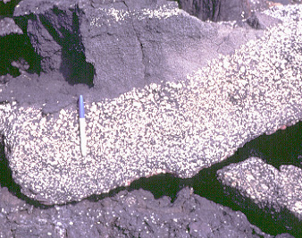
Pinta, also known as Abington,Island is an elongate shield rising from a northwest trending submarine ridge. The summit, at 850 m elevation, has a small collapse pit, but no caldera is present. The island has steep slopes, which may be due to faulting. Pinta appears to have had a two stage development: a shield stage, which began more than 800,000 years ago, and a younger fissure stage. The latter has produced many young lavas and cinder cones at the northern and southern ends of the island. There has been one recorded eruption in the past century. Many of the lavas erupted during the shield stage have very abundant large white crystals of plagioclase. While plagioclase is common in basaltic lavas, the remarkable abundance and size of these crystals is extremely unusual. Rocks such as these have been given the name "abingtonite" after the island. Abingtonites are occasionally found elsewhere in the Galapagos, particularly on neighboring northern islands. Plagioclase is often lighter than basaltic magmas from which they crystallize. The formation of abingtonites most likely involves the concentration of plagioclase in the tops of magma chambers through floatation. Most Galapagos magmas seem to be derived from a mixture of material from the Galapagos mantle plume and ambient upper mantle.Geochemically, Pinta magmas represent the northern extreme of the range of compositions observed in the Galapagos, indicating they are derived mostly from the Galapagos mantle plume. This contrasts with magmas from neighboring Marchena and Genovesa, which are derived mostly from the ambient upper mantle. The Last of His Race Pinta once had a thriving tortoise population, but the population was decimated by whalers and fisherman. The introduction of goats to the island by fisherman in 1958 may have been the last straw. At present, there is only one surviving member of this race, a male named "Lonesome George" who is held at the Darwin Research Station. For years it was hoped a mate of the same race could be found for George. When that was given up, several females, related in the sense that they were "saddlebacks" but nevertheless of different races, were placed in George's pen, but George showed little interest in mating. Other efforts to encourgage George to mate also failed. At present it seems that when George dies, so will the Pinta race of giant tortoises. |
| Isla Rabida |
|
Rabida, also known as Jervis Island, is one of two small islands locate to the south of Santiago. Though small, it contains a great variety of rock and lava types, including basalt, ferrobasalt, icelandite, and trachyte. Also to be found are a range of gabbroic xenoliths. The range of lava compositions is a result of fractional crystallization. As magma cools, crystals form and settle out. As a result, the composition of the magma changes, generally becoming richer in silica and poorer in magnesium. The xenoliths are fragment of magma that crystallized and depth and where broken off and carried to the surface during an eruption. It is interesting that these differentiated rocks (i.e., products of extensive fractional crystallization) are restricted to the central portion of the Galapagos archipelago, occurring on Alcedo, Pinzon, and Rabida. Rabida is essentially a cluster of of steep-sided, coalescing domes, flows, and pyroclastic cones. An irregular depression in the center may be a crater, but it has no caldera. The oldest rocks on Rabida are about 1 million years. Some of the pyroclastic cones on the north coast are probably much younger however, as then erode quite rapidly. A salt pond formed between these cones is one of the many places where one can see flamingos in the Galapagos. These spectacular birds feed exclusively on the brine shrimp found in these saline ponds. Interestingly, their distinctive pink color comes from the shrimp themselves. Young flamingos are white and only acquire the pink color after they begin to feed on the shrimp. |
| Isla Sierra Negra |
|
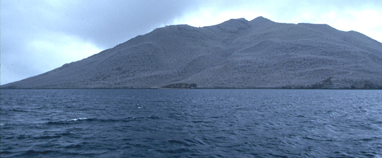
Sierra Negra rises to an elevation of nearly 1500 meters (4890 feet) and is located in the southeast of Isla Isabela, (or Albermarle Island). It is the largest and one of most active volcanos in the archipelago, with 10 known eruptions since 1813, the most recent in 1979. Over ninety percent of the surface of the volcano is younger than 4500 yrs, judging from cosmic ray exposure ages of lavas. Though Sierra Negra shares a number of characteristics with the other large western Galapagos volcanos, such as steep upper slopes that give it an "inverted soup-bowl" shape, it does differ in several respects. First, its slopes are somewhat gentler, and its has a broader coastal apron than those of its neighbors; second, there is a prominent rift system that runs from northeast to southwest which deflects around the caldera. In this respect it is similar to the Hawaiian volcanos, which also have prominent rift systems. As in Hawaii, many of the eruptive vents on Sierra Negra are located along the rift. The 1979 lava flow erupted from a vent called Volcan Chico, located along the rift just to the northeast of the caldera. Sierra Negra's caldera is somewhat unusual as well. It is elliptical, with its long axis aligned northeast southwest, whereas calderas on the other western volcanos are nearly circular. At 7 by 10 km, it has easily the largest caldera in the Galapagos. At is 100 and 140 m deep, is also the shallowest caldera. The caldera is structurally complex and has clearly collapsed in several stages. Much of the caldera floor is covered by quite young lava flows. The composition of Sierra Negra's lavas are quite uniform, yet they differ markedly, particularly in trace element abundances from it that of its neighbor to the north, Volcan Alcedo. Thus they neighboring volcanos derive there magma from distinct areas of the the mantle through different plumbing systems. Sierra Negra is, however, compositionally similar to it western neighbor, Cerro Azul, which is currently erupting. It is concievable that magma feeding these two volcanos is derived from a common melting zone in the mantle. The southern flank of Sierra Negra is the windward side and often bathed in clouds and mist. As a result, it is heavily vegetated. This area is the site of two of the oldest settlements in the Galapagos, the coastal village of Villamil and the town of Santo Tomas, located 20 km inland high on the flank of the volcano. Santo Tomas was orginally established to mine sulfur from the fumeroles in the area. Some cattle and goat ranching occurs on the southern slopes, and there are many feral cattle and goats as well. |
| Isla Fernandina |
|
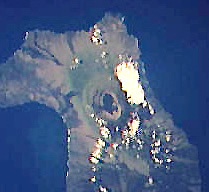
Fernandina, also known as Narborough Island, consists of a single large volcano, which rises to an elevation of 4500 feet (1400 m). It is probably the youngest volcano in the archipelago and is certainly the most active, erupting every few years, most recently in 1988, 1991, and 1995 (which produced a large lava flow from a vent on the west flank. Like the volcanoes of Isabela, it has a distinctive "inverted soup-bowl' shape with steep upper slopes and a large central caldera. Fernandina's caldera is over 1100 feet deep. At times, a small lake has formed in the north part of the caldera. The lake was last present in 1988; it disappeared after a section of the caldera wall collapsed. Calderas form as a result of collapse following magma withdrawal from the underlying magma chamber. The calderas of the Galapagos probably form from multiple collapses. The most recent collapse (and the only historically documented collapse of a caldera in the Galapagos) on Fernandina occurred in 1968. The collapse followed a brief eruption at an elevation of about 700 m on the eastern flank on May 21. At 10 AM on June 11, an earthquake occurred and was followed by the rise of a large white cloud that was visible from Santa Cruz. At 4 PM, a dark ash cloud was spotted by a fishing boat in Urvina Bay, 35 km east of the caldera. At 5 PM a large boom was heard and was followed by smaller exposions for several hours and a number of earthquakes that lasted over a week, the largest of which was a magnitude 5 occurring on June 15. A party from Darwin Station reached the summit on June 19, but could see little because of the dust generated by constant avalanches. When the dust finally did clear a week later, it was apparent that the southeastern part of the caldera floor had dropped as much as 300 m, with only minor subsidence on the opposite side. Calderas may also grow when parts of the wall break off, collapsing into the caldera. A southeast section of Fernandina's caldera wall collapsed in this way following the 1988 eruption, widening the caldera by 300 m and producing a 250 m thick pile of debris in the bottom of the caldera. Many of the lavas on Fernandina originate from crcumferential fissues on the wide, flat bench surrounding the caldera or vents near the base of the ediface. Others orginate from vents aligned along radial fissures on the lower flanks. Interestingly, there are few radial fissures in the summit area and few circumferential ones on the lower flanks. Most of the lavas are aa, as opposed to pahoehoe. Pahoehoe lavas on Fernandina are largely resticted to vents on the coast plain. Aa is extremely difficult to walk on, making the climb to the summit a difficult one. Whether a lava flow forms pahoehoe or aa depends on flow rate. The predominance of aa probably reflects a combination of steep slopes and high magma discharge rates. You can find out more about Fernandina at the Fernandina Web Site hosted by the NASA EOS IDS Volcanology Team at Michigan Technological University. Fernandina has not suffered as much from the presence of man (particularly, the animals he has left) as other islands, so the indiginous wildlife is still abundant. Among the animals to be seen there are marine and land iguanas, tortoises, hawks, sea lions and a great variety of sea birds, such as flightless cormorants. |
| Volcan Alcedo |
|
Volcan Alcedo is located in the center of Isabela, (also known as Albermarle Island) located between Volcan Darwin to the north and Sierra Negra to the south. The composition of its lavas differs from that of both its neighbors, indicating it has an independent magma plumbing system. It quite symmetrical and rises to an elevation of 1100 m (3650 feet). Relative to its size and height, Alcedo's caldera is large (7 to 8 km in diameter) and shallow (270 m deep). A steam vent, or fumerole, is located on the western side of the caldera. Only one historic eruption is known, a basaltic lava that erupted the southeast flank sometime between 1946 and 1960 (based on comparison of air photos). Volcan Alcedo is unusual in that its flanks are mantled by rhyolite pumice. Rhyolite is a light-colored volcanic rock that is produced by fractional crystalization. This occurs when basaltic magma intrudes into the crust and cools. As it does, it crystallizes, the crystals settling out. As a result, the composition of the magma steadily changes, becoming poorer in magnesium and iron and richer in silicon. The low iron content accounts for its light color compared to basalt. Alcedo is probably the oldest volcano on Isabela, and may be in the final phase of its evolution. This may account for its unusual lava chemistry and morphology. |
| Volcan Ecuador |
|
Volcan Ecuador is located at the northwestern end of Isla Isabela and is one of the most geologically puzzling features in the Galapagos. The other Isabelan volcanoes are nearly radially symmetric, but Volcan Ecuador is certainly not. It appears to be missing its entire western half. Furthermore, both the northern and southern flanks are much steeper than usual and are clearly not constructional surfaces. These flanks have apparently been oversteepened by erosion or faulting, or both. It is unclear whether Volcan Ecuador has simply grown with its present amphitheater-like morphology, or whether the western half of the volcano was faulted down into the sea or simply eroded away. Because Volcan Ecuador is in the rain shadow of other Isabelan volcanoes, its climate is very dry, hence the only mechanism for erosion is waves. Its seems extremely unlikely that waves alone could have eroded away the entire western half of the volcano, or produred the oversteepening of the northern flanks (though they are clearly responsible for some of the cliffs in the south). On the other hand, extremely large landslides have been documented on the Hawaiian volcanoes. Large slices of the Hawaiian volcanos appear to have slipped into the sea along accruate faults. It is certainly possible that the western half of Volcan Ecuador was lost in a just such a catestrophic landslide. If so, it probably produced and enormous tsunami (some times called a tidal wave.) Whatever its evolution, Volcan Ecuador does have a caldera, like its neighbors in the western Galapagos. A view into the caldera shows that the present floor, barely above sealevel, is covered by young fresh lava. A bench surrounding this may be the remenant of an earlier caldera. An other interesting aspect of Volcan Ecuador is that the chemistry of its lavas, particularly in trace element and isotopic composition is quite distinct from that of its neighbor, Volcan Wolf. Furthermore, the composition of these lavas shows significant variation, in contrast to the very homogeneous character of the other Isabelan volcanos. Possibly, Volcan Ecuador is younger than the other volcanos and has not yet developed the mature plumbing system that produces homogeneous lavas. A team of geologists from Cornell University, the University of Idaho, the Ecole Normale Superieure de Lyon, and Lawrence University visited Volcan Ecuador in January of 1997. Their research program should provide answers to some of the questions about Volcan Ecuador in the next few years. Volcan Ecuador could easily be mistaken for the remenant of a extinct volcano (and indeed was in some early geological studies). However, although there have been no reported historic eruptions, its central caldera and northern and eastern flanks are covered by many young lavas flows, some of which are probably not more than a few hundred years old. A fissure zone that runs east-northeast toward Volcan Wolf has been particularly active, and is constructing a ridge between the two volcanos. It is possible that within the last 10,000 years or so, Volcan Ecuador was an island. Thus whatever its history, Volcan Ecuador is quite active, and is most likely still in a relatively youthful stage. |
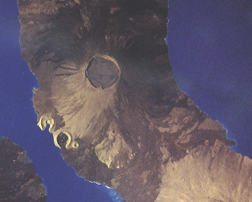
| Volcan Wolf |
|
Volcan Wolf, located at the northeast end of the island of Isabela (also known as Albarmarle Island) is the highest volcano in the Galapagos, reaching an elevation of over 1700 meters (5600 feet). Like the other western volcanoes, it has a large caldera. Volcan Wolf's caldera is slightly elongate in a NW-SE direction, measuring 5 by 7 km, and, with a depth of 600 m, it is the second deepest in the Galapagos. Volcan Wolf is among the most active volcanos in the Galapagos. The caldera floor is covered with young lava and many young flows may be seen on its flanks, particularly on the eastern side. Ten historic eruptions have been documented between 1797 and 1982. The 1982 eruption was particularly spectacular: fountains of lava emenating from a vents in the caldera floor rose above the caldera rim. Because of its steep slopes, most of the lavas on Wolf are of the aa type, making the climb to the summit a difficult one. The distribution of vents on Volcan Wolf is typical of that of the western volcanoes. Vents are aligned along circumferential fissures on the summit plateau. On the flanks, however, most vents are aligned along radial fissures. A particularly active ESE-WNW aligned fissure zone connects Volcan Wolf to its western neighbor, Volcan Ecuador, which is much smaller. Although they abut each other, Volcan Wolf and Volcan Ecuador differ markedly in the composition of their lavas, particularly in trace element and isotopic composition. There is also a clear distinction in lava chemistry between Wolf and its southern neighbor, Volcan Darwin (although less marked than that between Wolf and Ecuador). In terms of isotopic composition, Volcan Wolf is quite unusual becuase isotope ratios are more similar to lavas erupted at mid-ocean ridges than those erupted at other oceanic islands. It shares this trait with several other Galapagos volcanoes, most notably Santa Cruz and Genovesa. Until very recently, the remoteness and steepness of Volcan Wolf had kept its biota relatively insulated from the effects of man and the animals he brought. However, the area is now threatened by the invasion of feral goats that is effecting most of northern Isabela and is most severe on Alcedo. Goats were first reported on Wolf in 1995. Goats devestate the natural flora, thereby threating the native herbivores such as the land iguana and giant tortoise. |
| Volcan Darwin |
|
Volcan Darwin is the second volcano south on Isabela, located between Volcan Wolf to the north and Volcan Alcedo to the south. It is nearly perfectly symmetrical and rises to an elevation of 1325 m (4350 feet) and is the fifth highest volcano in the Galapagos. Like the other western volcanos, it has a large central caldera, nearly 5 kilometers (3 miles) in diameter and 200 m deep (700 feet). A number of young lava flows may been seen within the caldera, as well as on the flanks of the volcano. The primary eruption patterns seems to be from circumferential fissures surrounding the summit caldera, though radial fissures are also apparent. There are no confirmed historic eruptions of Volcan Darwin, but an 1801 eruption in "central Isabela" witnessed by Amasa Delano from anchorage in James Bay on Santiago could have been Volcan Darwin (Alcedo is the other possibility). Nevertheless, many of the lavas are quite young and no more than a few hundred years old, thus Volcan Darwin certainly remains an active volcano. Two young pyroclastic cones, Tagus Cone and Beagle Cone, are located at the shore on the west flank of the volcano. Tagus Cone is partially breached and forms and excellent anchorage known as Tagus Cove, which has been a favorite stopping place for centuries. In the last century, whaling ships would anchor there to supplement their provisions with tortoises. Tortoises were particularly favored because they could be kept alive in the holds of ships for months without water or food. The Beagle anchored there in 1835 and Darwin spent considerable time exploring the area. Today, Tagus Cove is one of the common tourist stops in the western Galapagos. Pyroclastic cones located near the shore, called littoral cones, such as Tagus and Beagle Cone, are common in the Galapagos. Darwin was the first to recognize that these cones form when basaltic magma comes in contact with seawater. When this occurs, the water is flashed to steam, and the magma fragments in to small ash particles that react with the steam to form palagonite, the light colored material of which the cones are composed. The entire process is quite explosive, and the ash is thrown into the air. It settles back to build a cone around the vent. Like the other large western volcanos, much of the surface of Volcan Darwin is covered by aa lavas. Aa lava surfaces are extremely rough and much more difficult to walk on than the other type of lava surface, pahoehoe. Some lavas flows begin as pahoehoe but convert to aa when flowing down steep slopes. The characteristic steep slopes of the western Galapagos volcanos is why aa lavas predominate. Tagus Cove is one of the many excellent localities to see Galapagos wildlife, particularly the abundant sea birds. Among those that may be seen here are the brown pelican and the blue-footed boobie. The vegitation in the area is typical of that in the dry lower elevations in the Galapagos, and include the unusual Palo Santo trees. These white-barked dwarf trees are leaveless and all but dead most of the year. They leaf out and spring back to life in the short wet season, which usually begins in March or April. The Darwin race of giant tortoises is usually found in the moister highlands, but females sometimes come down to the Tagus Cove area to nest. Volcan Darwin was investigated in 1986 by a team of geologists from the University of Oregon and Cornell University. |
| Isla Espanola |
|
Espanola, also known as Hood, is one of the smaller Galapagos Islands, measuring 7 by 14 km and reaching an elevation of just over 200 m. Espanola is the oldest Galapagos Island, or at least the island on which the oldest lavas have been found. These lavas are 3.4 million years old as determined by K-Ar dating. For some time, it was thought that the evolution of the unique fauna and flora of the Galapagos must have occurred within this time (i.e., the last 3 and 1/2 million years). It is now clear, however, that there have been islands in the Galapagos for much longer. An eight million year old flat top seamount located several hundred km to the southeast on Carnegie Ridge was once a Galapagos Island and has been carried eastward by the motion of the Nasca plate. Thus Espanola's age does not constrain the amount of time available for evolution. Indeed, there may have been islands in the Galapagos for 80 million years, plenty of time for the unique flora and fauna of the Galapagos to evolve. Espanola appears to represent roughly the northern two thirds of a once larger volcano. The southern coast of the island is a vertical cliff 100 m or more high. This appears to be a fault scarp; the southern half of the volcano has been faulted into the sea. Other east-west faults can also been seen. Thus Espanola appears to have been subjected to the same tectonic processes that have disrupted Santa Cruz and Santa Fe. Since it is low, Espanola is particularly dry and inhospitable. Without a reliable source of fresh water, it has not been settled and has not been as threatened by introduced mammals as some other islands. This is not to say, however, that its wildlife has not had problems. By 1959, only 12 females and 2 males of the distinctive saddleback tortoises of the Espanola race remained. This was too few to maintain a breeding population. In the early 1960's all these animals, as well as an additional male located zoo in the U.S., were brought to the Darwin Research Station and a captive breeding program begun. Thanks to this program, Espanola now has a growing population of young tortoises. Nests were observed in 1990 and hatchlings in 1991. By 1995, about 700 tortoises raised at Darwin Station had been returned to Espanola. The prognosis for this race is now quite good. While inhospitable to terrestrial life, Espanola is a haven for seabirds. It has the largest known colony of waved albatrosses, magnificent birds of enormous wing span. The high southern cliffs provide the elevation these large birds need to take off. Many other bird, such as the red-billed tropic bird, may also be seen there. The Espa?la race of marine iguanas have particularly striking red coloration. In the northeast of the island at a site called the blowhole, wave energy focused by cracks in the rocks produces enormous gysers of seawater to the delight of onlookers. |
| Isla Santa Fe |
|
Santa Fe, also called Barrington Island, is located in the central part of the Galapagos archipelago. It is one of the oldest Galapagos Islands, ages of its lavas range from 750,000 to nearly 3 million years. The lavas are simiIar in some respsects to the Platform Series lavas of neighboring Santa Cruz. Santa Fe is also one of the few islands that is not volcanically active. Its maximum elevation is only about 200 m. There have, however, been unconfirmed reports of fumeroles on the island. The present island represents only a part of a larger volcanic edifice, the west coast is defined by a fault along which the western have of the volcano has been down-thrown. After volcanic activity ended (and probably only recently in a geologic sense), Santa Fe has been cut by a series of east-west faults that have produced a series of horst and grabens. There is no fresh water on the island so it has been relatively undisturbed by human activity and ferel animals. Among the unique species that can be seen there are the land iguana and Galapagos snake (whose bite is mildly poisonous). |
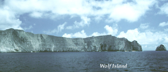
| Isla Wolf and Isla Darwin |
|
Wolf and Darwin Islands, also known as Wenman and Culpepper respectively, are two eroded volcanos located on a volcanic ridge (the Wolf-Darwin Lineament) aligned northwest-southeast. The ridge extends from the northwest part of the Galapagos Platform to the Galapagos Spreading Center, some 150 km to the north. Though Wolf reaches a maximum elevation of only 250 m and Darwin only 165 m above sea level, the islands are only the tips of much larger volcanos that rise more than 1000 m above the sea floor. Both volcanos are now extinct; potassium-argon ages of Darwin show it to be 400,000 years old, while ages of lavas from Wolf range from 900,000 to 1,600,000 years. There are several smaller volcanos located along the Wolf-Darwin lineament that do not reach the sea surface. Potassium-argon ages from some of these seamounts are as young as 30,000 years and these volcanos are probably still active. The origin of the Wolf-Darwin Lineament remains somewhat enigmatic. One hypothesis is that it reflects channeled flow of material from the Galapagos mantle plume to the Galapagos Spreading Center within the uppermost mantle. Another hypothesis is that is a fault or tear in the lithosphere that allows magma to rise to the surface. These two small islets are inhabited only by sea birds and are rarely visited. The relatively quite waters in the bay formed by Wolf's caldera is, however, a wonderful place for snorkelling and scuba diving. |
| Isla Cerro Azul |
|
Cerro Azul volcano occupies the southwest corner of Isla Isabela (Albermarle Island). Although smaller than it neighbor to the west, Sierra Negra, at 1690 m (5541 feet) its summit is higher. Cerro Azul is quite active, with 9 known historic eruptions, the most recent of which began in Sept, 1998 and has continued into October (updated information about this eruption can be found on the Galapagos News page). That eruption was somewhat unusual because lava erupted both from a vent near the eastern base and from a vent within the caldera. Because of its remoteness, it is likely that many eruptions over the last several hundred years have gone unnoticed. The composition of Cerro Azul's lavas is quite uniform and rather similar to that of Sierra Negra's. Both Cerro Azul and Sierra Negra have strong enrichments in incompatible elements, indications that these melts are derived primarily from the Galapagos mantle plume rather than entrained asthenosphere. Cerro Azul's caldera is elongate in a ENE-WMW direction and is among the smallest in the western Galapagos, measuring roughly 4 km by 3 km. Nevertheless, at 650 m (2000 ft), it is among the deepest of the calderas in the western Galapagos. The caldera is quite complex, with numerous embayments and benches, indicating it formed not in a single event, but through multiple collapses. A large cinder cone may be seen in the caldera floor. Numerous young flows erupted from an arcuate vent system on south rim of the caldera, and cascaded down the caldera wall to pond in the caldera floor. A lake has developed in the last decade or so and now occupies much of the northeast half of the caldera floor. Caldera lakes are not uncommon in the Galapagos, but they are rarely permanent. |