|
|
|
|
 | There are two coordinate systems in Stingray, the Geographic Coordinate System and the Local Cartesian Coordinate System. The geographical coordinate system can be either geodetic (latitude, longitude, elevation) or universal transverse mercator (easting, northing, elevation). The local cartesian system (x, y, z) is the system that Stingray/TomoLab use for ray-tracing and inversion, respectively. Each of these are described below
Geographic Coordinates
Local Cartesian Coordinates
Vertical coordinates: Elevation vs. model Z-value
|
|
|
|
|
|
| Geographic Coordinate System (Geodetic or UTM coordinates)
|
|
|
|
 |
|
|
| The Geographic Coordinate System can be either geodetic or Universal Transverse Mercator (UTM) coordinates.
Geodetic Coordinates: Geodetic coordinates are (lat, lon, elevation). Lat-lon pairs are in decimal degrees; elevation is with respect to the geoid. A reference ellispoid (wgs84) is used to map these pairs to the Local Cartesian Coordinate System, defined below. Mapping is done by map2xy.m and discussed in srGeometry structure.
UTM Coordinates: Easting-northing pairs in kilometers. Note that easting-northing pairs are usually in meters; departure from convention. UTM zone is not defined. UTM coordinates are mapped to the Local Cartesian Coordinate System, defined below. Mapping is done by map2xy.m and discussed in srGeometry structure.
Items such as station and event locations and a topographic/bathymetric map are referenced to the Geographic Coordinate System.
|
|
|
|
 |
|
|
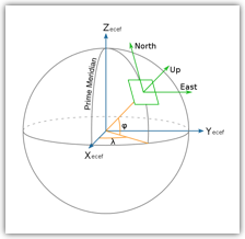
| Figures shows both geodetic coordinates expressed as λ, φ and ENU (east-north-up) cooridinate system.
In Stingray, the Local Cartesian System is identical to ENU, IF there is no rotation of the LCS.
|
|
|
|
|
|
| Local Cartesian Coordinate System (xyz coordinates, km)
|
|
|
|
 |
|
|
| Stingray calculates ray paths and travel times in a Local Cartesian Coordinate System (xyz coordinates, km); the local cartesian coordinate system can be rotated with respect to NS/EW or easting/northing.
There is a mapping from the geographic coordinate system to the local cartesian coordinate system. The cartesian system is right-handed with z positive upward. If the local cartesian system is unrotated, the x and y directions point east and north, respectively.
The local cartesian coordinate system (x and y axes) can be rotated with respect to the geographic coordinate system. Positive rotation is in the CCW direction; see diagram below. This allows the graph for network ray tracing to be adjusted to match the experiment geometry.
Currently, short distance conversion factors are used to map between spherical coordinates (lat-lon pairs) and the cartesian coordinate system.
|
|
|
|
|
|
|
| Illustration of the two coordinate systems (click on the thumbnail to see it):
Stingray_coord.ai.pdf
|
|
|
|
|
|
| Vertical-coordinate systems in Stingray.
|
|
|
|
 |
|
|
| Elevation (kilometers or meters): Elevation is measured relative to the reference ellipsoid with positive elevation values upward. Thus OBS positions and bathymetric maps require negative numbers.
Model z-value (kilometers): Model z-value is measured in kilometers relative to the top layer of nodes that define the surface of the velocity model. Z is positive upward. To convert model z-value to elevation it is necessary to combine with an elevation map. See srElevation Structure.
The velocity model is hung from the elevation. This is accomplished by shearing vertically the columns of nodes that define the graph.
|
|
|
|
|
|
|
| Illustration of vertical coordinate systems
StingrayVertical.pdf
|
|
|
|
|