Introduction to GPS
The Global Positioning System (GPS) is a system of 24 Navstar satellites, owned and operated by the United States Department of Defense that has revolutionized navigation and survey capability. The system is composed of the satellite space vehicles (SVs for short), land-based control stations, and end-user GPS receiver units. The GPS receiver units use triangulation to determine precise location and elevation on the surface of the Earth. To determine location, four signals from four different orbiting SVs are required, and a precise time must be known. Time is continuously updated on the receiver units using a signal from any one of the 24 GPS SVs. Accurate time is fed to the SVs from land-based atomic clocks through the GPS control stations. Trimble™ GPS uses decoded GPS signals that are far more accurate than common retail GPS units.
GPS technology has a wide range of applications. The technology was initially developed by the U.S. military as a war-fighting tool. GPS aids in navigation of ships and planes, in the targeting of weapons systems, and in applications such as war planning and battle field analysis. The technology quickly began to find its way into civilian applications during the 1990s. Currently GPS is used for marine navigation, back-country travel, survey work, and data collection related to another new spatial analysis technology, the Geographic Information System (GIS).
GPS is a key tool used by our team to accurately and precisely survey Western Pond Turtle habitat. The Trimble™ GPS units allow our team to locate and mark potential habitat features on BLM land and enables us to download our data directly into the Bureau of Land Management's GIS. The Trimble™ GPS units allow our team members to do more than simply locating habitat features and marking their position. The units allow our team members to create a digital record for each site surveyed in which the surveyor(s) record data such as air temperature, feature size, and canopy cover. The technology ensures that all data collected is associated with a defined geographic location that can be found and traveled to by any one with access to the BLM's GIS. This enables the BLM staff to re-investigate sites if they wish and helps them to determine potential sites for habitat restoration or creation. The GPS technology allows our team to survey habitat on BLM lands in a powerful new way that would not be an option 15 or 20 years ago.
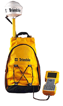
The GPS Pathfinder® Pro XRS receiver is an easy-to-use GPS receiver designed for GIS data collection and data maintenance. The GPS Pathfinder Pro XRS receiver provides real-time submeter accuracy GPS with built-in SBAS, OmniSTAR, and beacon capabilities. With built-in real-time options there is less equipment to worry about, and productivity is maximized in the field.
Together with a field computer and the corresponding software, the GPS Pathfinder Pro XRS receiver provides two-way data flow between the field and GIS, facilitating the data collection and data maintenance processes, and ensures that one always has current data for decision-making.