|
|
|
|
|
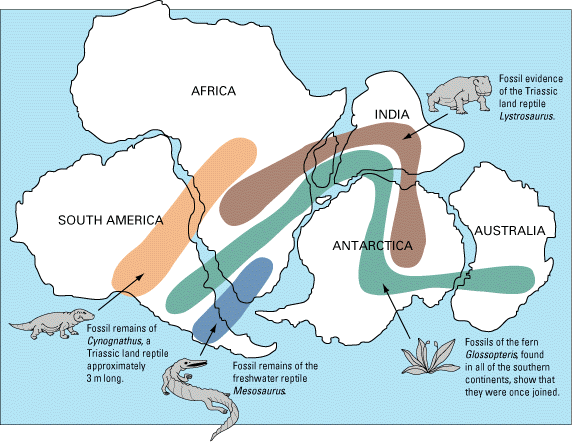
The reason that this idea, which seems so compelling, was not initially accepted was that no one could imagine how things like continents could move around (or more precisely, what could push continents around). We believe that we have a reasonable idea for the mechanism underlying tectonic motions (however the details still elude us).
Recall that the interior of the Earth is hot and that it can be divided into the crust, mantle, and core based upon chemical differences but that from a mechanical standpoint, it was better to consider the crust and the outer part of the mantle as one unit, the lithosphere and the plastic layer underneath as one unit, the asthenosphere. Some properties of the lithosphere are as follows:
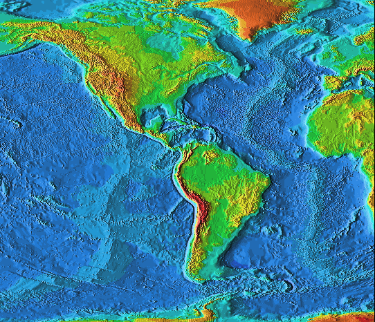
The oceanic crust is thin (< 6 km) and is composed of basalts, similar to those found in lunar maria. The oceanic crust is denser than the continental crust.
The continental crust is thicker (~ 20 - 70 km) and is composed of granites. Granites (as are the basalts) are igneuous rocks, however, granites were formed under high pressure below the surface of the Earth. The continental crust is less dense than the oceanic crust.
The lithospheric plates are thought to be moved around by convective motions (e.g., Oatmeal convection, horizontal motion ). Because the Earth is hottest at its center and cools as one moves outward an outward flow of heat is set up. Through the solid portions of the Earth, the heat is carried by conduction, but in the liquid and in the liquid and plastic portions of the Earth, the heat is carried by convection.
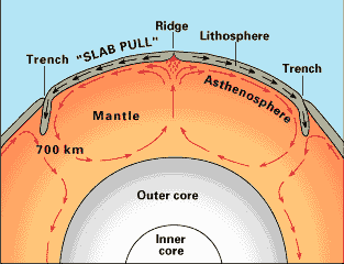 |
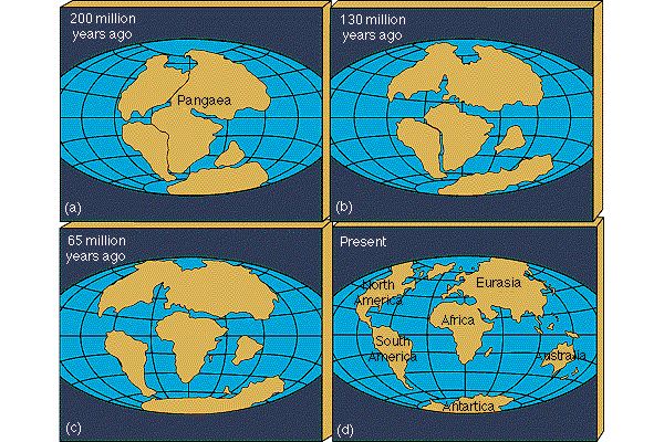
The large scale circulations (motions) in the asthenosphere move the overlying lithospheric plates on the surface of the Earth leading to the continental drift observed today. |
The lithospheric plates separate (new crustal material is produced) near rifts. There is a large rift in the mid-Atlantic stretching from Iceland to Antarctica, the mid-Atlantic Ridge. Overall, there are around 60,000 km of active rifts on the surface of the Earth. Most are in the oceans, but some are on land, e.g., the Great Rift Valley in Africa. New crust is thus continuously created. The oceanic crust is replaced roughly on a time scale of 200,000,000 years.

 |
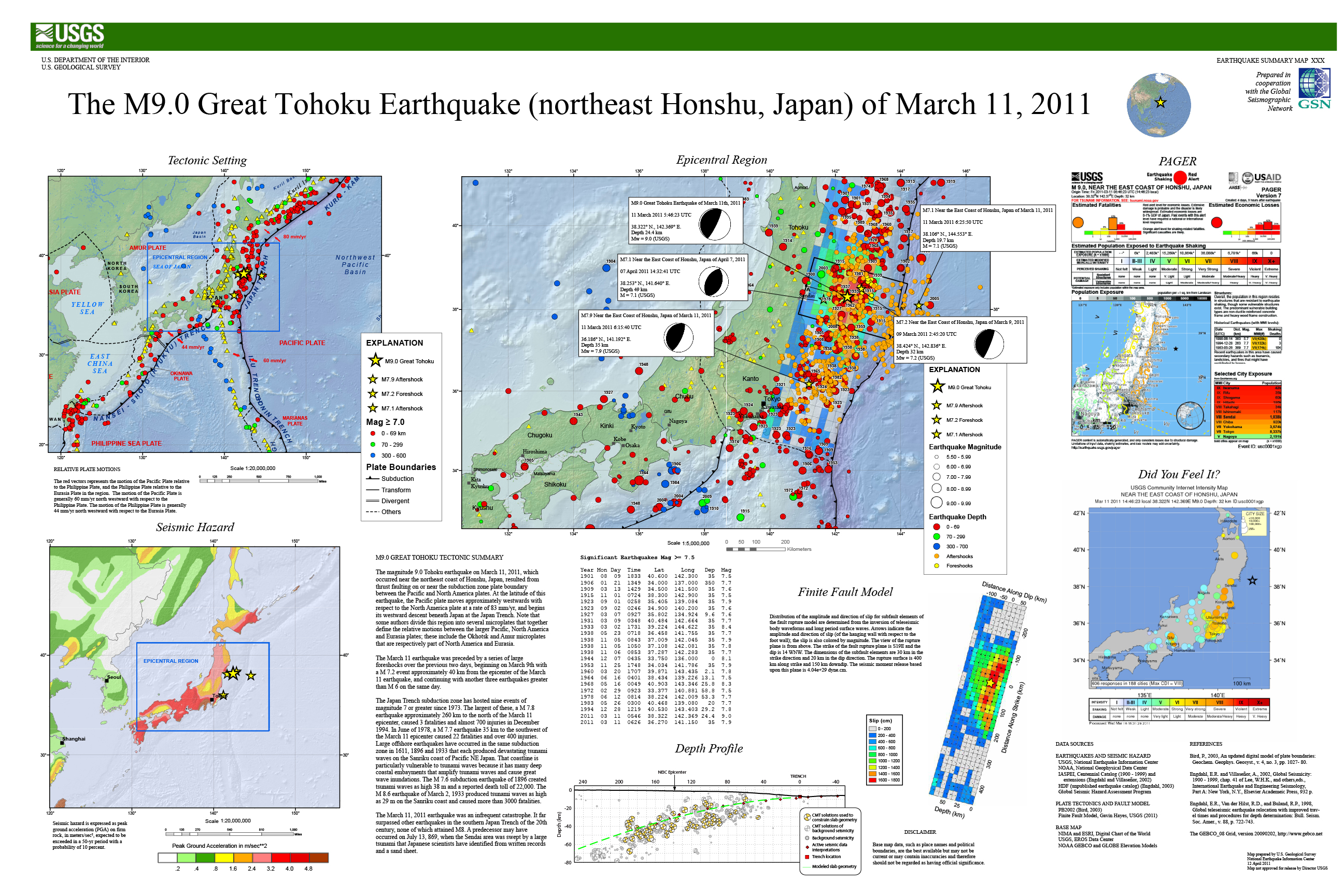
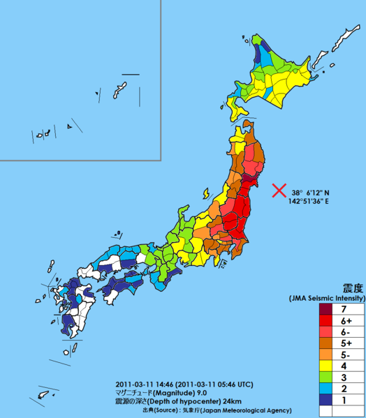
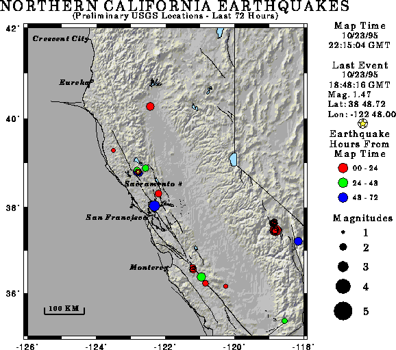
Subduction zones occur where continental plates meet oceanic plates (note that the oceanic basin spreading from the mid-Atlantic ridge pushes the North American and South American plates, there is no subduction zone at the eastern coasts of North and South America). Because the oceanic plates are denser and thinner than are the continental plates, they are forced inward (into the Earth). The oceanic plates are forced downward to the regions of high temperature where the rocks are melted (around 200 - 300 km below the surface). Some of the released material is re-inputed to the surface via volcanoes while most is recycled into the mantle to be spewed out in rift zones. Near subduction zones you find oceanic trenches, mountain ranges, volcanism, and earthquakes. Of particular interest to us is the Juan de Fuca plate which forms a shallow angle subduction zone. Shallow angle subduction zones lead to violent activity such as earthquakes and volcanism. In Oregon, we get large earthquakes every 500 years or so. The last happened at 9 pm on January 26, 1700, the Cascadia earthquake, magnitude 8.7-9.2. This is large; a magnitude 6 earthquake has 1 Megaton of seismic energy. A magnitude 7 earthquake has 32 Megatons of seismic energy. A magnitude 8 earthquake has 1,000 Megatons of seismic energy. A magnitude 9 earthquake has 32,000 Megatons of seismic energy! We are roughly due for a large earthquake. |
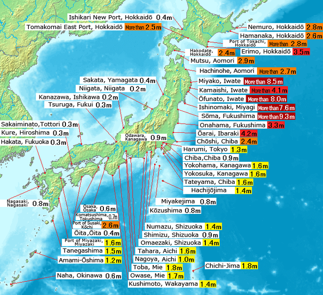
Great Tohoku Earthquake, 11 March 2011
|  |
 |
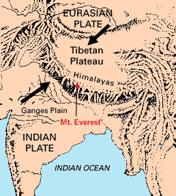
 | When two continental plates collide, because there is no strong tendency for one plate to slide under the other, we get mountain range formation. An example of this is the Himalayan mountain range. |
 |
Comment: