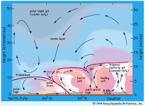
Positions of jet streams in the atmosphere. Arrows indicate directions of mean motions in a meridional plane.
Among the more fascinating features of upper-air circulations are discontinuous bands of relatively strong winds (usually in excess of 30 metres per second) called jet streams. As with other wind fields that increase with increasing height, jet streams can be explained as an application of the thermal-wind equation. They are located above areas of particularly strong temperature gradients--e.g., frontal zones. In such areas, the pressure gradients and the resulting wind speeds increase with increasing height so long as the temperature gradients persist in the same direction. In general, this will extend to the tropopause, after which the temperature gradient reverses direction and the wind speeds diminish. Thus, jet streams are usually found in the upper troposphere (i.e., at levels of nine to 18 kilometers).
Because regions of strong temperature gradients can be created in different ways, there are several classes of jet streams. Perhaps the most familiar is the polar-front jet stream. As noted earlier, the polar front is the boundary between polar and mid-latitude air. In winter this boundary may extend equatorward to 30 , while in summer it retreats to 50 -60. Winter fronts also are distinguished by stronger temperature contrasts than summer fronts. Thus, jet streams are located more equatorward in winter and are more intense during that time. Such streams are generally strongest east of major continents, sometimes exceeding 75 metres per second.
The polar-front jet is important for several reasons. First, because it is a region of maximum upper-tropospheric flow, it is also one of concentrated upper-air divergence and convergence. Divergence is favoured in the downstream, poleward sector of the jet core as well as in its upstream, equatorward sector. This means that such regions are favoured, though not exclusive, regions for extratropical cyclone development and inclement weather. Second, the polar-front jets, which move west to east but meander with the general upper-air waves, often "steer" the movement of major low-level air masses. This steering is simply a reflection of the very strong mass transport associated with jet streams. Identification of changes in jet-stream flow can often assist in predicting major changes in air mass--hence in temperature and weather--over a region. Third, jet streams are an important factor in high-altitude flight. Military and civilian jet aircraft depend heavily on reliable information about upper-air winds, which is used for planning the duration of flights and corresponding fuel consumption. Furthermore, jet streams generate a great deal of turbulence because of their strong wind shears. Airlines seek to avoid such "clear-air turbulence" in order to maximize passenger safety and comfort.
A second jet stream is located at the poleward limit of the equatorial tropical air above the transition zone between tropical and mid-latitude air. This subtropical jet stream is usually found at latitudes 30 to 40in general westerly flow. This jet may not be marked by pronounced surface temperature contrasts but rather by relatively strong temperature gradients in the mid-troposphere. Moreover, when the polar-front jet penetrates to subtropical latitudes, it may merge with the subtropical jet to form a single band. The subtropical jet, which is generally weaker and located at higher elevations than its higher-latitude cousin, is less commonly associated with migrating cyclones; instead, it may be accompanied by sporadic periods of strong convection, along with heavy rain showers. Also peculiar to the tropical latitudes of the Northern Hemisphere is a high-level jet called the tropical easterly jet stream. Such jets are located about 15 N over continental regions due to the latitudinal heating contrasts over tropical landmasses that are not found over the tropical oceans.

Positions of jet streams in the atmosphere. Arrows indicate directions of mean motions in a meridional plane.
Excerpt from the Encyclopedia Britannica without permission.