

About This Print
Source: report of The General Insurance Association of Japan (SONPO) 予 防時報 230 Summer 2007 and as footnoted.In September 1896, devastating floods hit the Tokyo area after several weeks of heavy rain. Multiple rivers in the Tokyo area, including the Arakawa, Tone, Tama, Naka, Edogawa and Sumida overflowed their banks causing severe flooding. Water levels rose over 24 feet in some places leading to the collapse of a number of embankments and dams. The flooding, which continued for several weeks, effected a broad area of Tokyo.
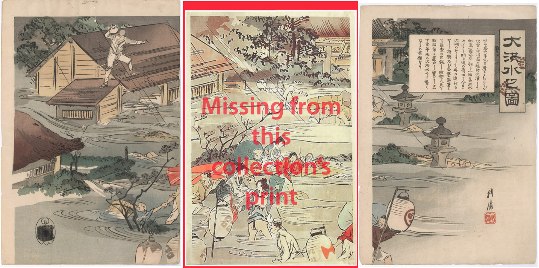
As the print's inset in the right panel explains (see below), the flooding was the worst in fifty years. The embankment of the Nakagawa collapsed and the entire area of Mukojima became a lake that could only be navigated by boat. Officials and police officers rescued people and did what they can to mitigate the disaster.
Only the left and right sheets of this triptych are part of this collection and the left sheet of this collection's print has the information in the publisher's seal blacked out. (Although most of the information in it can be made out after image enhancement as shown in the Print Details below.) It is unknown why the blacking out was done and I have seen this on other copies of this print.
The scene depicted in this print includes the area around the Mimeguri Shrine along the Sumida River, whose torii is pictured at the top of the center and right sheets of the print.
During the Meiji Era up until the 1896 flooding, major flooding occurred in the Tokyo area in 1870, 1878, 1885, 1887, 1889, 1890 and 1892.1 This flooding, particularly the 1893 and 1896 floods, led to the passing of the first River Law in 1896, which "brought centralization in river control." "The River Law assigned the central government as the responsible party for flood control measures that demanded large funds..." leaving the local government "responsible for ordinary flood management."2
Despite these and subsequent efforts there are major low-lying areas of Tokyo that remain extremely vulnerable to floods, as reported by The Japan Times on July 5, 2019:
It’s not only Edogawa. Most areas in the low-lying “five wards of Koto” in eastern Tokyo — also including Adachi, Katsushika, Koto and Sumida — will be submerged in a worst-case scenario, it said, affecting 2.5 million people, or over 90 percent of the entire population of the five wards combined. 3
Inset Detail
明治 29年 9月の府下の水害は、中川筋の堤防が決壊し て向島一円本所の一部が一面の大洪水となった。 昨日までの青田は今日は大湖のようになり舟で往 来した。府庁および各警察署から巡査が出張し防 御し人民を救助するなどの尽力が実った。50余年 来の大洪水には驚くばかりである。
1 Ministry of Land, Infrastructure, Transport and Tourism report https://www.mlit.go.jp/river/basic_info/jigyo_keikaku/gaiyou/seibi/pdf/naka-5-4.pdf
2 Urban Water in Japan, ed. Rutger de Graff, Fransje Hooimeije, Routledge, 2008, p. 97.
3 The Japan Times https://www.japantimes.co.jp/news/2019/07/05/national/one-year-deadly-flooding-western-japan-disaster-resonates-vulnerable-areas-tokyo/#.XrN2tahKiUk
Print Details
| IHL Catalog | #1834 |
| Title or Description | Illustration of the Disastrous Flood 大洪水之図 |
| Artist | Ōkura Kōtō (1873-1910) |
| Signature | 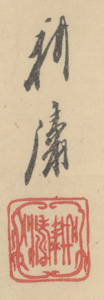 |
| Seal | unread seal (see above) |
| Publication Date | October 1, 1896 [printed September 28, 1896] (as shown below) |
| Publisher |  |
| Impression | excellent |
| Colors | excellent |
| Condition | excellent - full margins, unbacked, minor marks |
| Genre | nishiki-e |
| Miscellaneous | |
| Format | vertical oban triptych |
| H x W Paper | Right sheet: 15 1/16 x 10 3/16 in. (38.3 x 25.9 cm) Left sheet: 15 1/4 x 9 7/16 in. (38.7 x 24 cm) |
| H x W Image | Right sheet: 14 5/16 x 10 3/16 in. (36.4 x 25.9 cm) left sheet: 14 1/4 x 9 3/8 in. (36.2 x 23.8 cm) |
| Literature | |
| Collections This Print | |
5/6/2020 created