Module Number: EU20
Module Name: France
Date:
Introduction
The geography of borders of modern France, the Atlantic and the Mediterranean coastlines to the west and south, are complemented by the line of the Vosges, Jura and Alps to the east and the the Pyrennies to the south-west. The lack of a natural 'border' on the north and north-east (Picardy and Lorraine) complicated the process of national formation. The breakdown of the Roman Empire (5th Century) was followed by phases of barbarian invasions and attempts to construct an enduring order along the lines of Germanic kingship. The dynasties however undermined such order treating their territory as private property and dividing it among their descendants. The division of Charlemagne's Frankish kingdom [A.D. 843] set the stage for the formation of France and other European nations. Conflicts with England especially during the Hundreds Year War, resulted in territorial integrity and a sense of national identity under the monarchy. In the 16th century, that unity was challenged by the wars of religion that raged across western Europe. Religious toleration was introducted by the Edict of Nantes was later revoked by Louis XIV, famously known as the Sun King. Under Louis XIV, France participated in many wars against many of the established European powers. Through this period the borders of France varied, but generally moved toward the lines we now observe. The Old Order in France collapsed in 1789. The French Revolution marked the end of the monarchy and resulted in the creation of the first French Republic. The effects of the Revolution led to turmoil throughout France, turmoil that was not brought under control until Napoleon seized power and began a systematic attempt to expand French control throughout western Europe. In 1814, Napoleon was definitely defeated and the national borders of Europe and France received a new and more enduring definition at the Congress of Vienna . The great wars of the 20th Century resulted in gains an losses on the eastern and north-eastern frontier. Alsace and Lorraine were again formally incorporated into France in 1919 when the Treaty of Versailles was signed. From that point the borders of continental France have been stable. La France d’outre-mer ['France Overseas'] is a term used to describe a number of islands in the Caribbean, Pacific and Indian Ocean that have been formally incorporated in to France.
|
|---|
Instructions to artist (including "legend / key")
These are the features I would like to be present on every map. The text should be well-defined and bolded for the first maps and then become translucent for the rest of the maps (the cities are a possibel exception).
1. Cities: Paris, Marseille, Lyon, Toulouse, Nice
2. Mountains: the Alps (located along the Southeastern border, the western part of the great alpine chain), the Pyrenees (located along the southwestern border, forms a natural border between France and Spain)
3. Rivers: The Rhône (rises in Switzerland, runs West to Lyon and goes South to its delta at Marseille into the Mediterannean), the Garrone (rises in the Pyrenees, flows to the Atlantic through Toulouse and Bordeaux), the Loire (France's longest river, rises in the Massif Central, runs north and then west through Orléans, Tours and Nantes into the Atlantic), the Seine (runs northwest through Paris, into the English Channel), the Rhine (does not flow through France but forms part of the Franco-German border)
Colors: France (blue), England (red), Spain (yellow), Italy (green), Germany (DARK GRAY).
Section 1
Title: Barbarian Kingdoms and Charlemagne's Empire
Frame 1: Clovis, King of the Franks
Caption: Clovis' Frankish Kingdom
Use map inventory numbers: EU20_43
After the fall of the Roman Empire, number of Germanic tribes, including the Franks and Burgundians, seized parts of Roman Gaul. The reign of the Merovingian king, Clovis, marked the return to some stability. This Frankish dynasty dominated much of what would later develop into France.
|
|---|
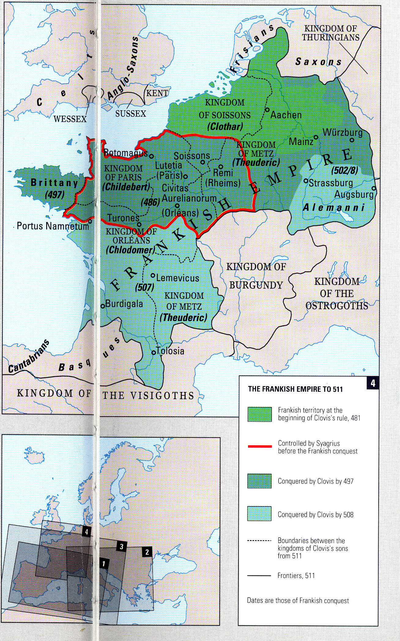
Frame 2: Expansion of the Kingdom
Caption: Expansion During the 6th Century
Use map inventory numbers: EU20_45
On his death in 511, the kingdom of Clovis divided his empire amongst his four sons. The latter expanded the empire to include the kingdoms of the Burgundians and the Ostrogoths, as well as lands to the Northeast and Southwest.
|
|---|
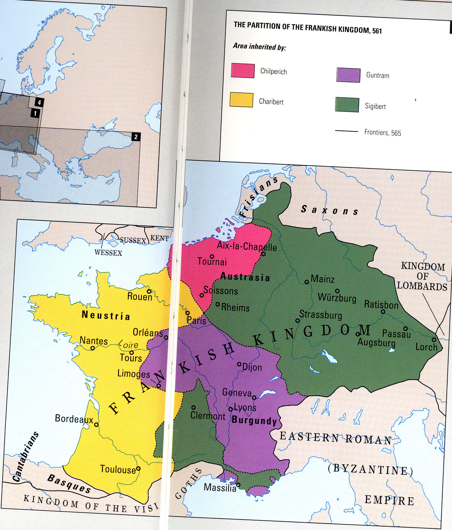
Frame 3: Division of the Kingdom
Caption: Division During the 6th Century
Use map inventory numbers: EU20_42
By 561, the Frankish Empire had been divided into three territories: Neustria, Austrasia, and Burgundy. Aquitaine in the Southwest was held by Moors and wouldn't be reclaimed until the Battle of Poitiers in 732.
|
|---|
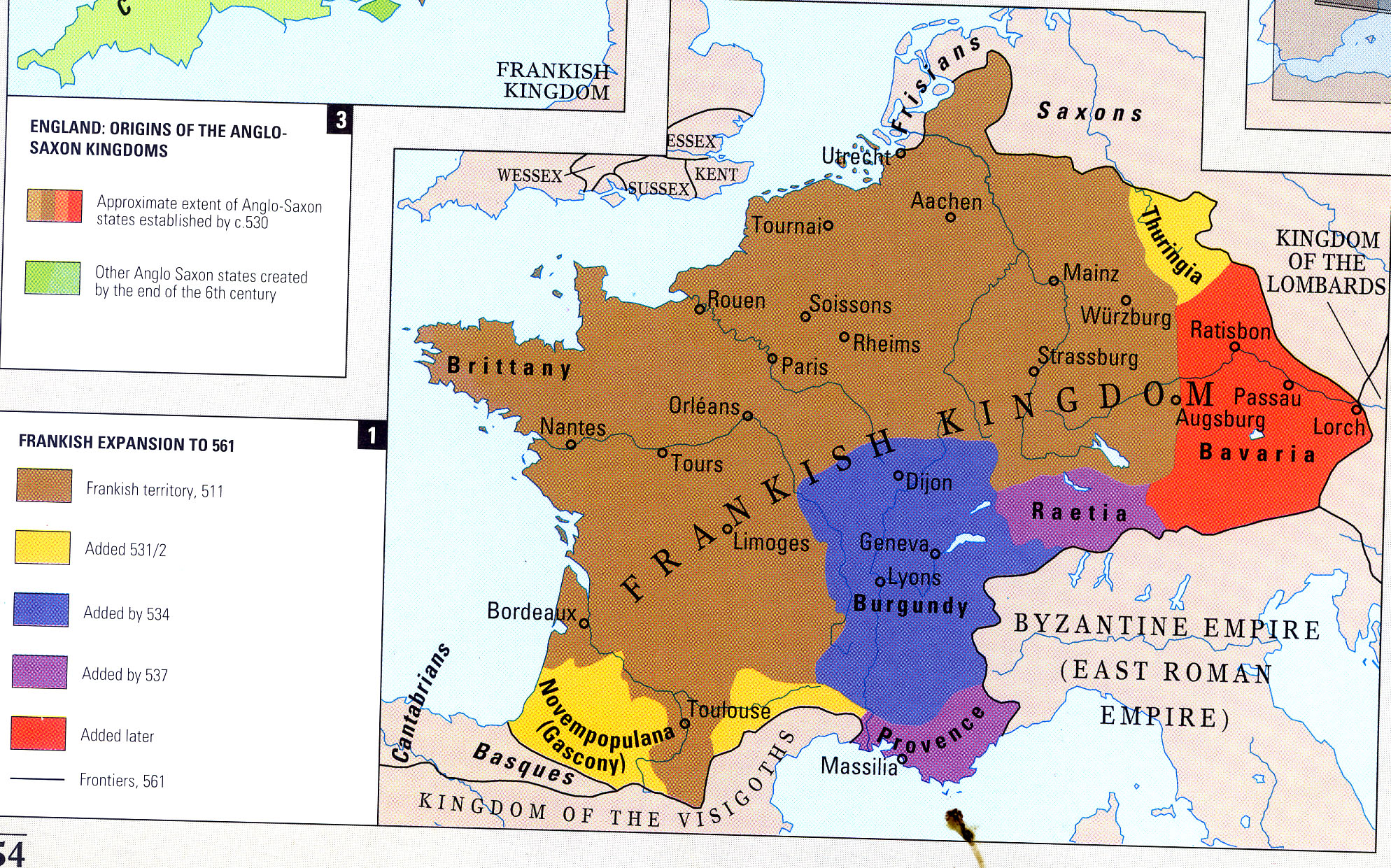
Frame 4: Further Division of the Empire
Caption: Clovis' Grandsons Divide the Empire into Fourths
Use map inventory numbers: EU20_46
In 561 after the Kingdom had been greatly expanded, Clovis' four grandsons divided the Kingdon once more amongst one another. FRAMES 3 AND 4 MIGHT BE UNIFIED AS ONE. |
|---|
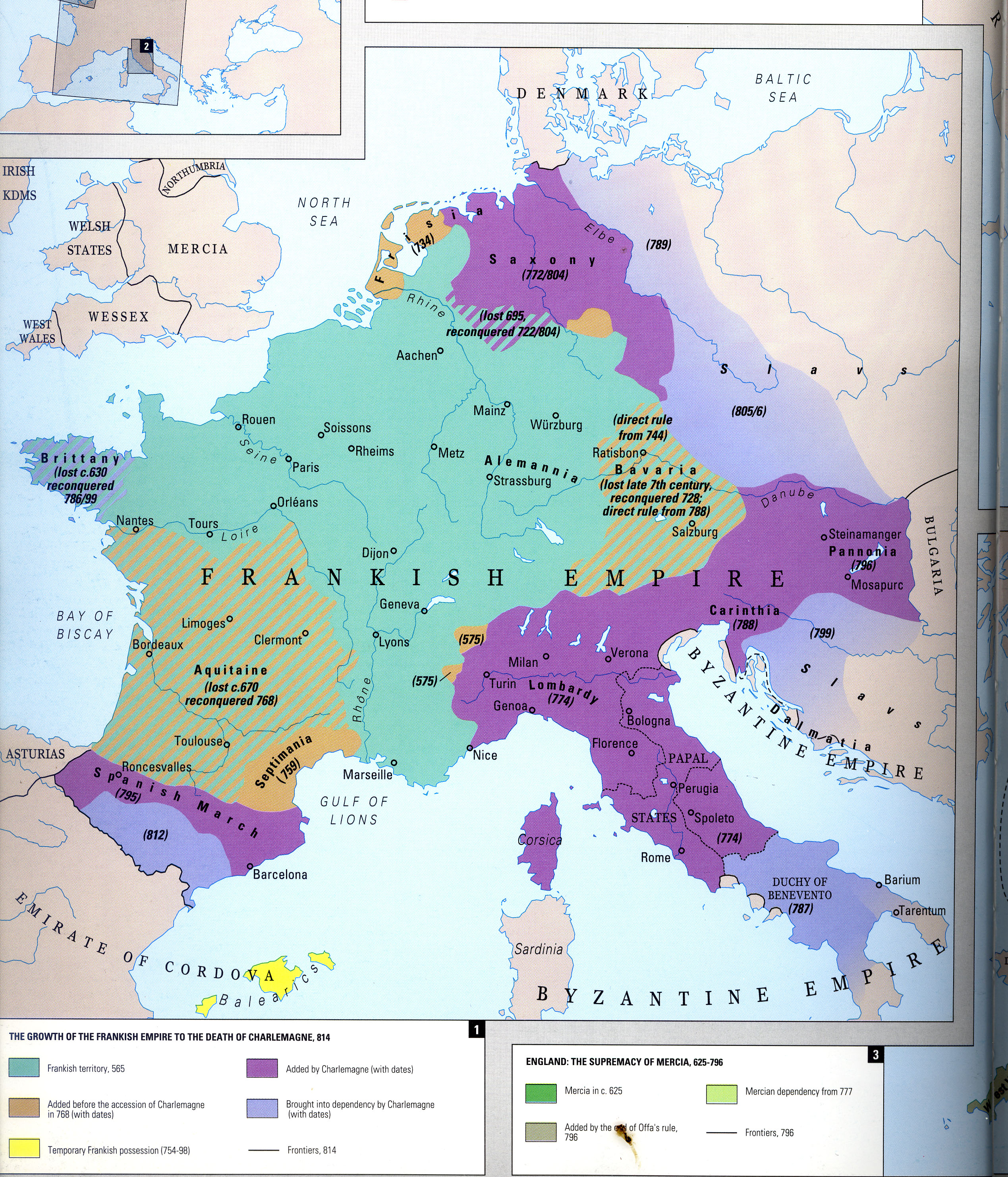
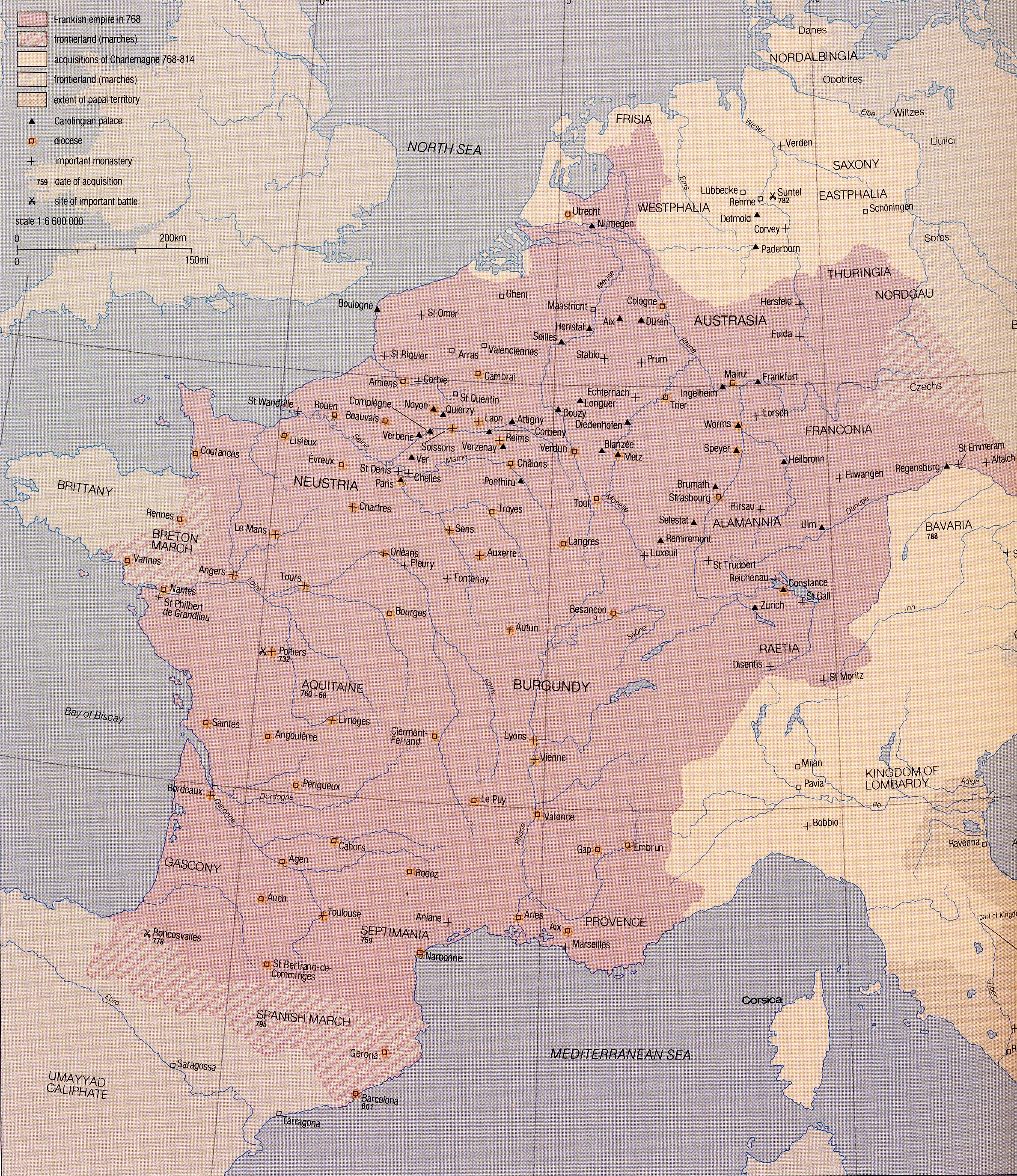
Frame 5: Charlemagne
Caption: Charlemagne's Empire
Use map inventory numbers: EU20_48, EU20_55, EU20_57
The Carolingians, first Charles Martel and the Charlemagne re-vitalized Frankish power in Western Europe. The authority of the latter was legitimized in the eyes of many when he was crowned Emperor by Pope Leo III in 800. Charlemagne created a highly decentralized form of government that could only be maintained through constant travel and continued military campaigns. |
|---|
Frame 6: The Carolingian Europe After Charlemagne
Caption: Triparte Division of Charlemagne's Empire
Use map inventory numbers: EU20_56, EU20_98
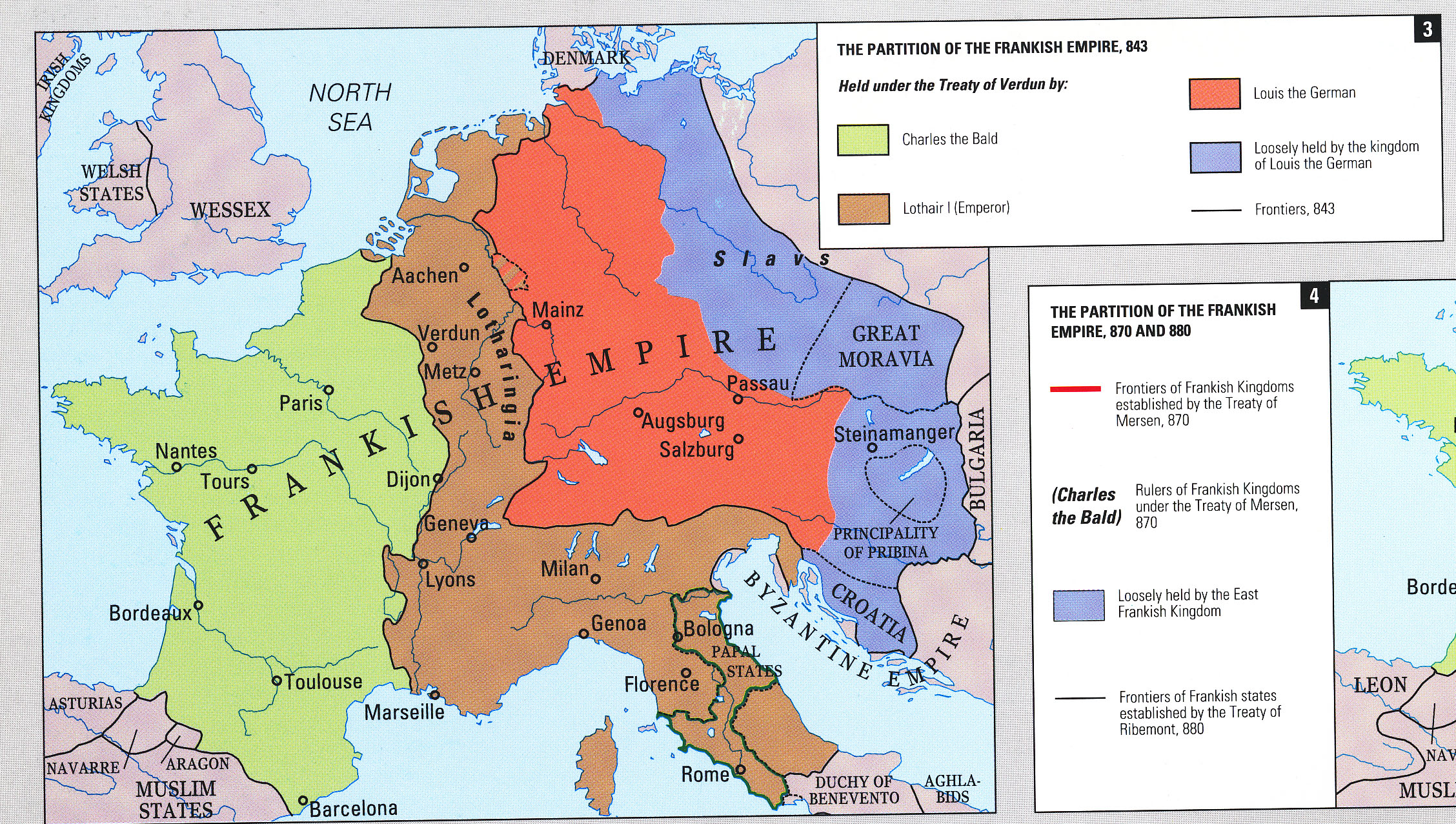
After his death, Charlemagne's empire was among his descendants first in AD 817. The Treaty of Verdun in 843 resolved the conflichts between his heirs, and created three kingdoms, the western one of which would emerge as France. The consequenses would be felt into the 20th Cent. |
|---|
Frame 7: TheLothar's Kingdom
Caption: Division of Lothar's Kingdom
Use map inventory numbers: EU20_56, EU20_49
Steve and Josh, the maps variously use Lothair and Lothar, please use the latter, Lothar.
After Lothar's death in 855, his kingdom was divided between his two sons Louis II and Charles. Further subdivisions were confirmed by treaties of Mersen (870) and Ribemont (880). |
|---|
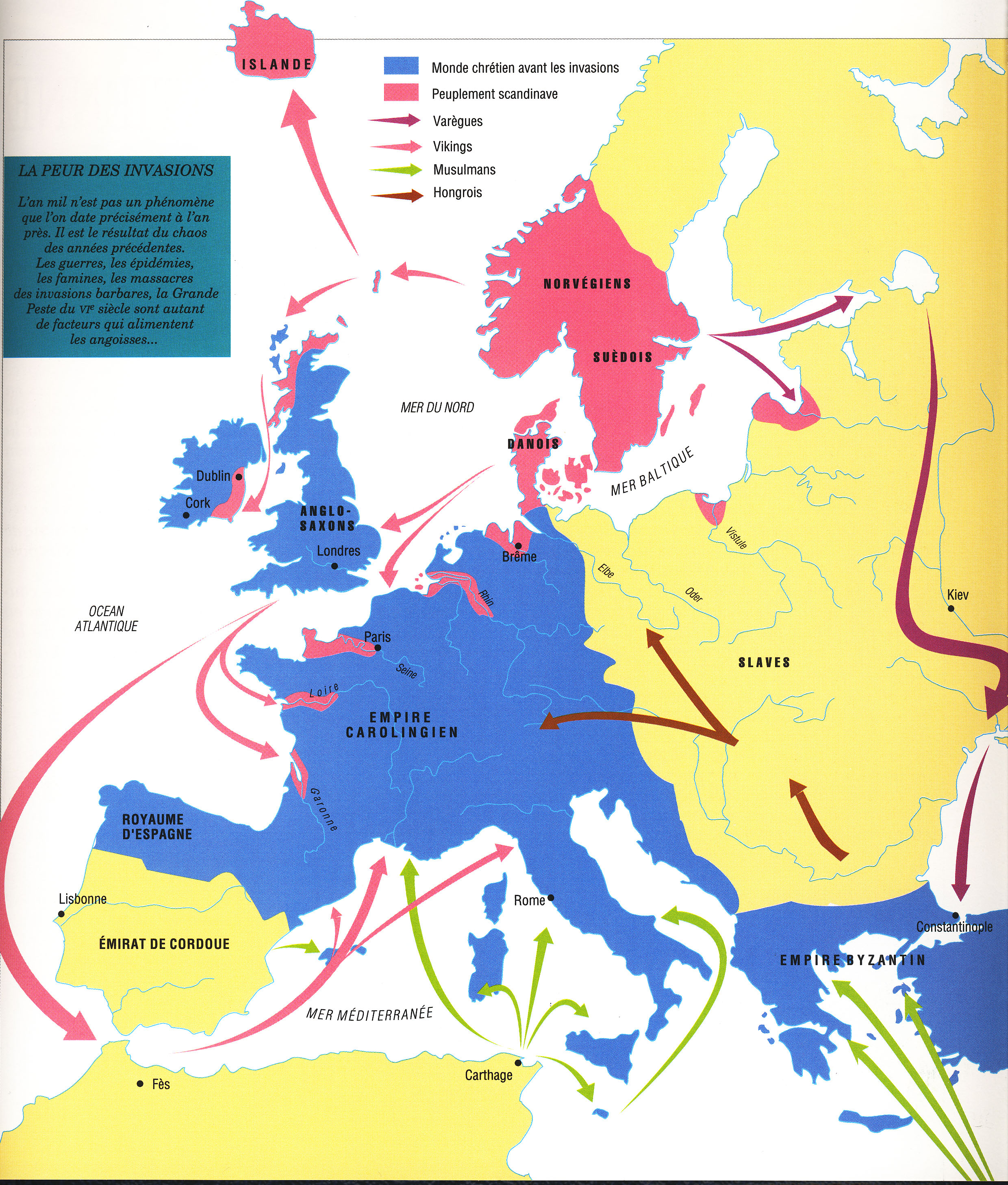
Frame 8: Barbarian Invasions
Caption: Barbarian Invasions Across the Frankish Empire
Use map inventory numbers: EU20_100-invas
In the second half of the 9th Cent. and continuing into the 10th Cent, the Carolingian kings faced a series of barbarian invasions from all directions. One cannot speak of 'terrritorial integrity' during this period.
|
|---|
Section 2:
Title: The Capetian Dynasty and Hundred Years War
Frame 1: 10th Century France
Caption: Viking Control Throughout France
Use map inventory numbers: EU20_60 Note especially the scandinavian settlements along the western rivers of France...peuple scandinaiviennes.
During the 10th Century, the monarchy yeilded control of several regions in the west notably to the Normands who settled along the important rivers of the Seine, the Loire and the Garonne. Flanders Aquitaine and Burgundy became functionally independent states. |
|---|
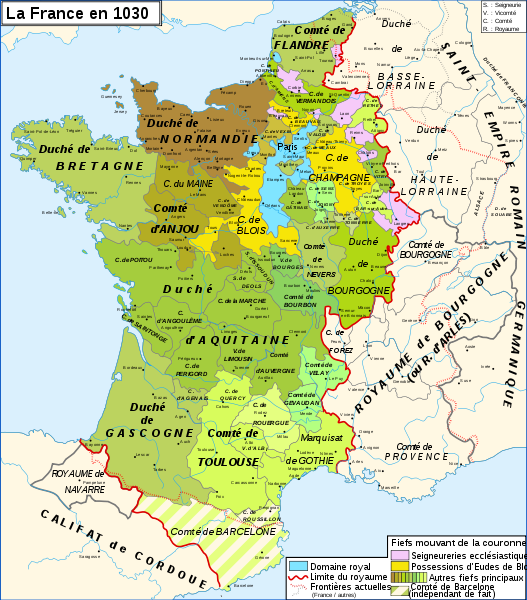
Frame 2: Capetian France
Caption: Growth of the Capetian Dynasty
Use map inventory numbers: EU20_101
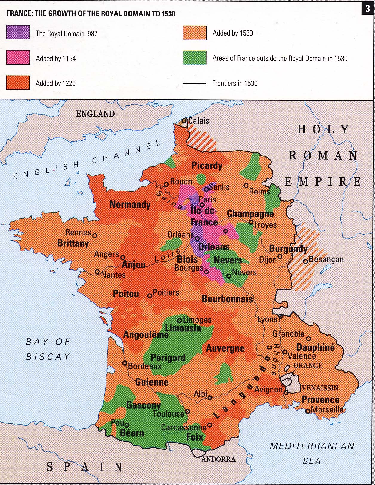
In 987 when Hugh Capet established the Capetian Dynasty around ' Île de France' , France was a patchwork of small states. This map illustrates the situation in 1032. |
|---|
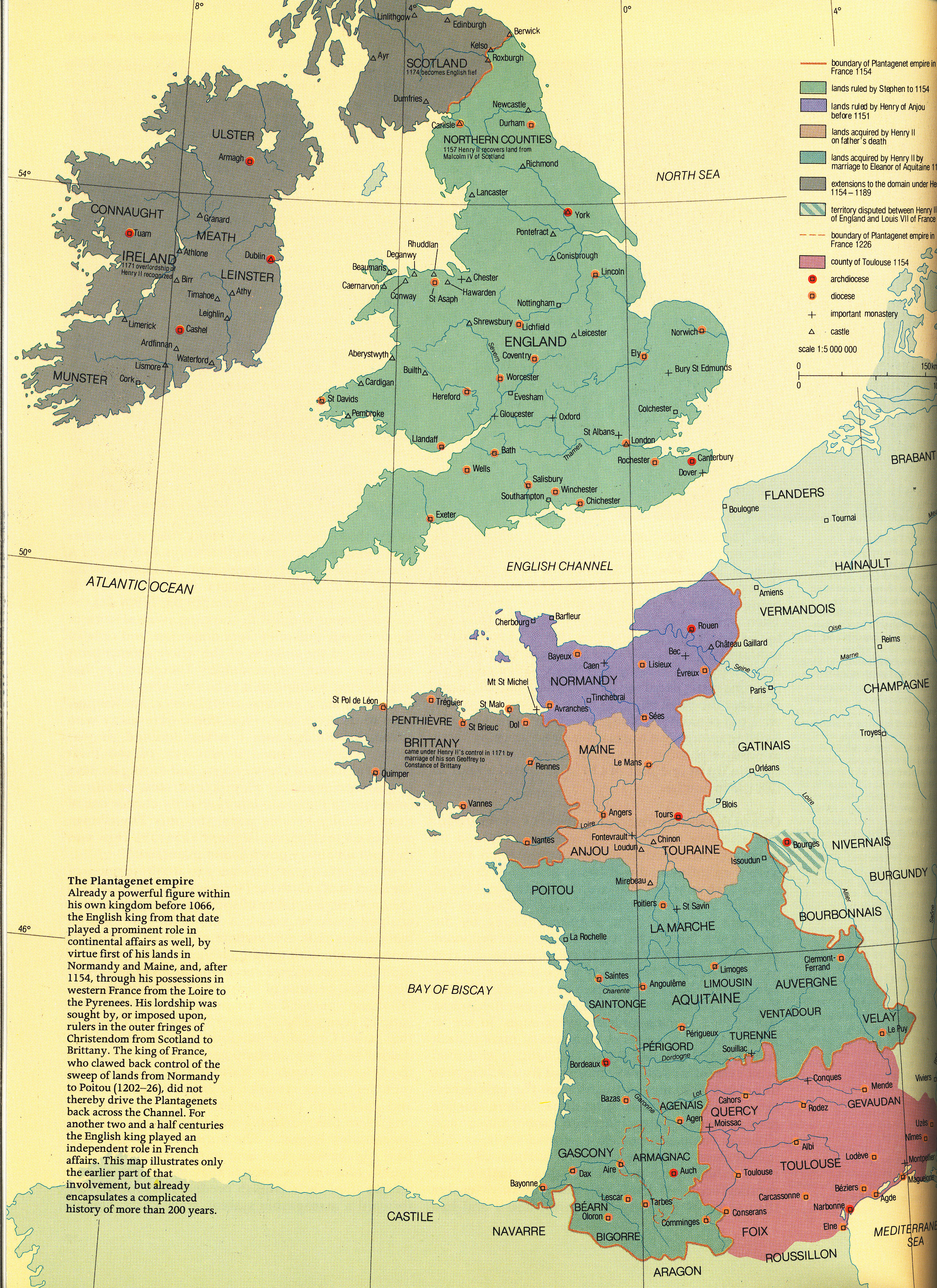
Frame 3: England and France
Caption: Growth of English Power in France
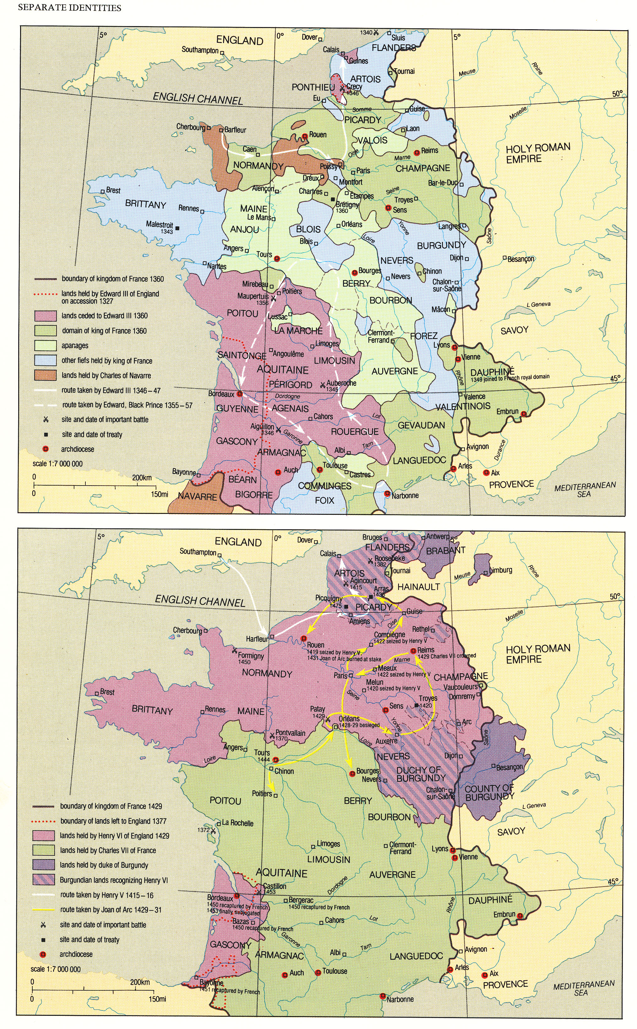
Use map inventory numbers: EU20_69, EU20_64; eleanor.
The William, duke of Normany, was a vassal of the French king and after 1066 also king of England. As the latter he and his successors tried to avoid meeting obligations to the French crown. By the mid12th Century, Henry II of England married Eleanor of Aquitaine and brought her patriomony to England. and extended English control of western France to include all of the Atlantic coastal area. ON MAP, USE BALLONS TO INDICATED DATE OF ACQUISTION THROUGH ELEANOR AND CONSTANCE. |
|---|
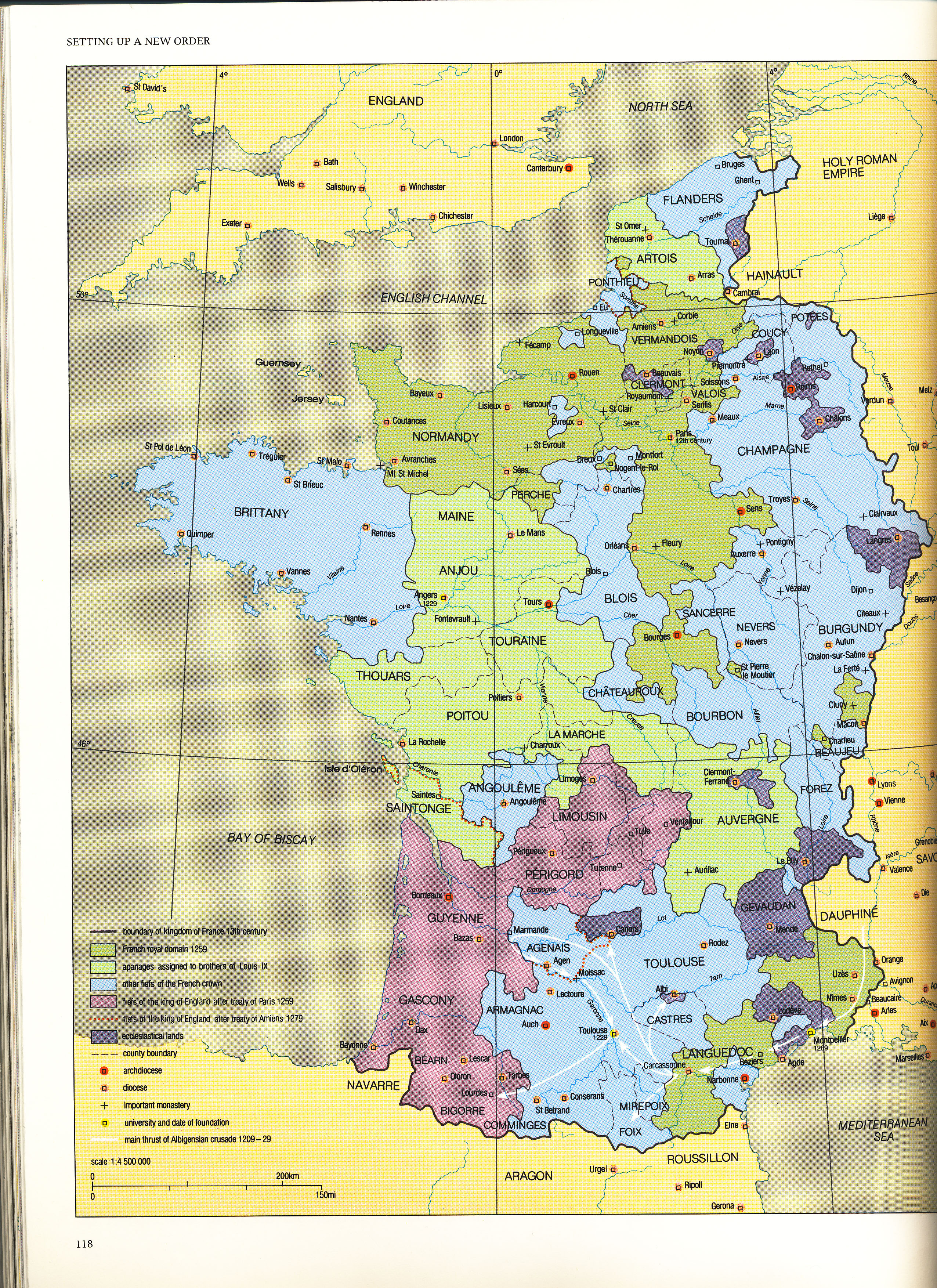
Frame 4: 13th Century France
Caption: Border Changes During the 13th Century
Use map inventory numbers: EU20_70, better france1223
The extinction of the 'senior' Capetian line led to open conflict for the throne. In the early 13th Century, Phillip II Augustus reclaimed some lands previously under English control. Under the reign of St. Louis IX, the Treaty of Paris in 1259 forced Henry III of England to recognize all former English possessions, with the exception of Guyenne, as Capetian.
|
|---|
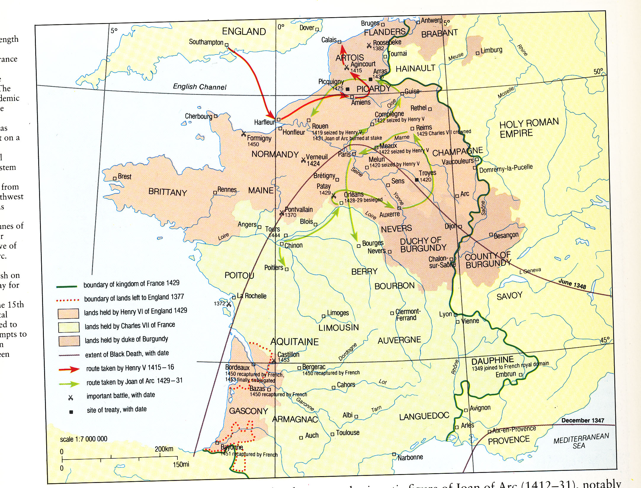
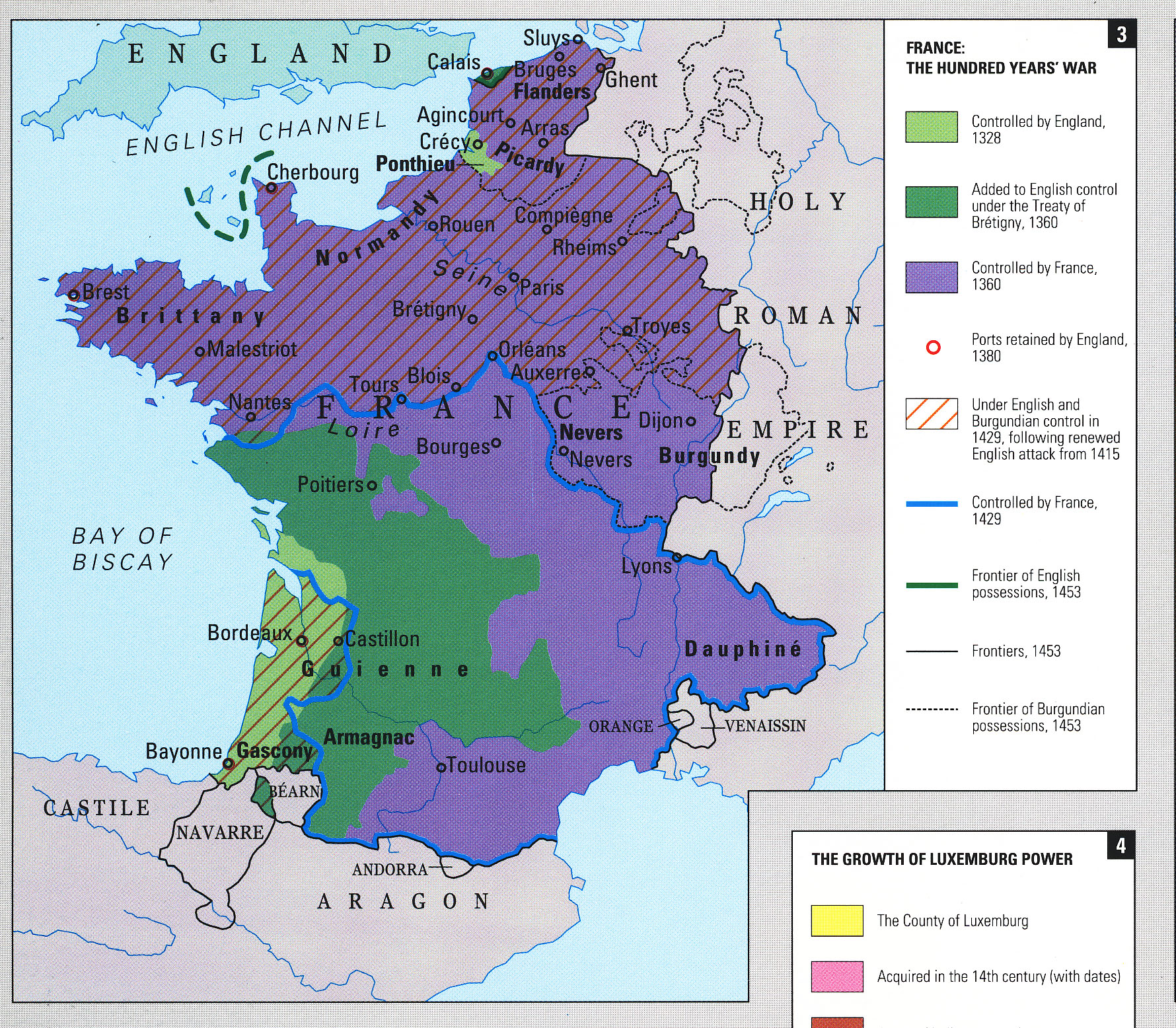
Frame 5: Hundred Years War 1337-1453
Caption: Changes During the 100 Years War
Use map inventory numbers: EU20_59, EU20_67, EU20_71, at end of the war
In 1337, a feudal dispute between Philip VI of France and Edward IV of England began the Anglo-Franco war, better known as the Hundred Years War. It lasted until 1453, when England conceded to defeat and only maintained their holding of Calais.
|
|---|
Frame 6: Restoration of France
Caption: Rebuilding France on its eastern frontier.
Use map inventory numbers: EU20_79; on burgundy EU20_85, EU20_86; EU20_80
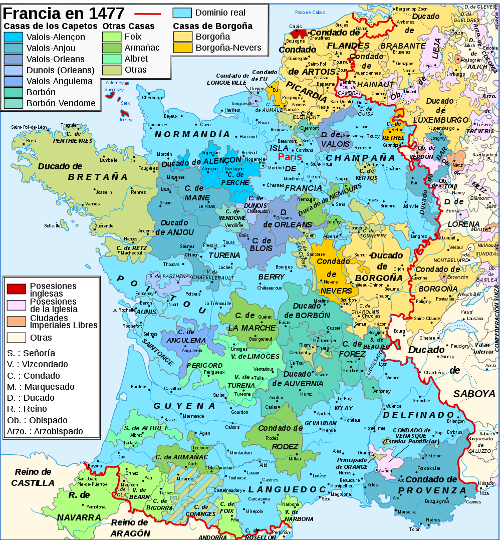
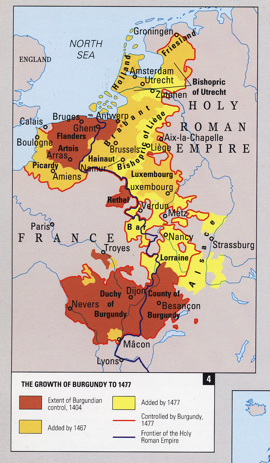
Charles VII and his son Louis XI help rebuild France after the Hundred Years War. It continued to rapidly expand from the end of the war in 1453 to 1491. During this period Burgundy was incorporated. By the end of the century Calais had falled and the in the east the 'three bishoprics' of Toul, Metz and Verdun added.
|
|---|
Section 3:
Title: Wars of Religion and the Ancien Regime of Louis XIV
Frame 1: The Huguenots
Caption: Protestants Communities in France
Use map inventory numbers: EU20_02, EU20_87
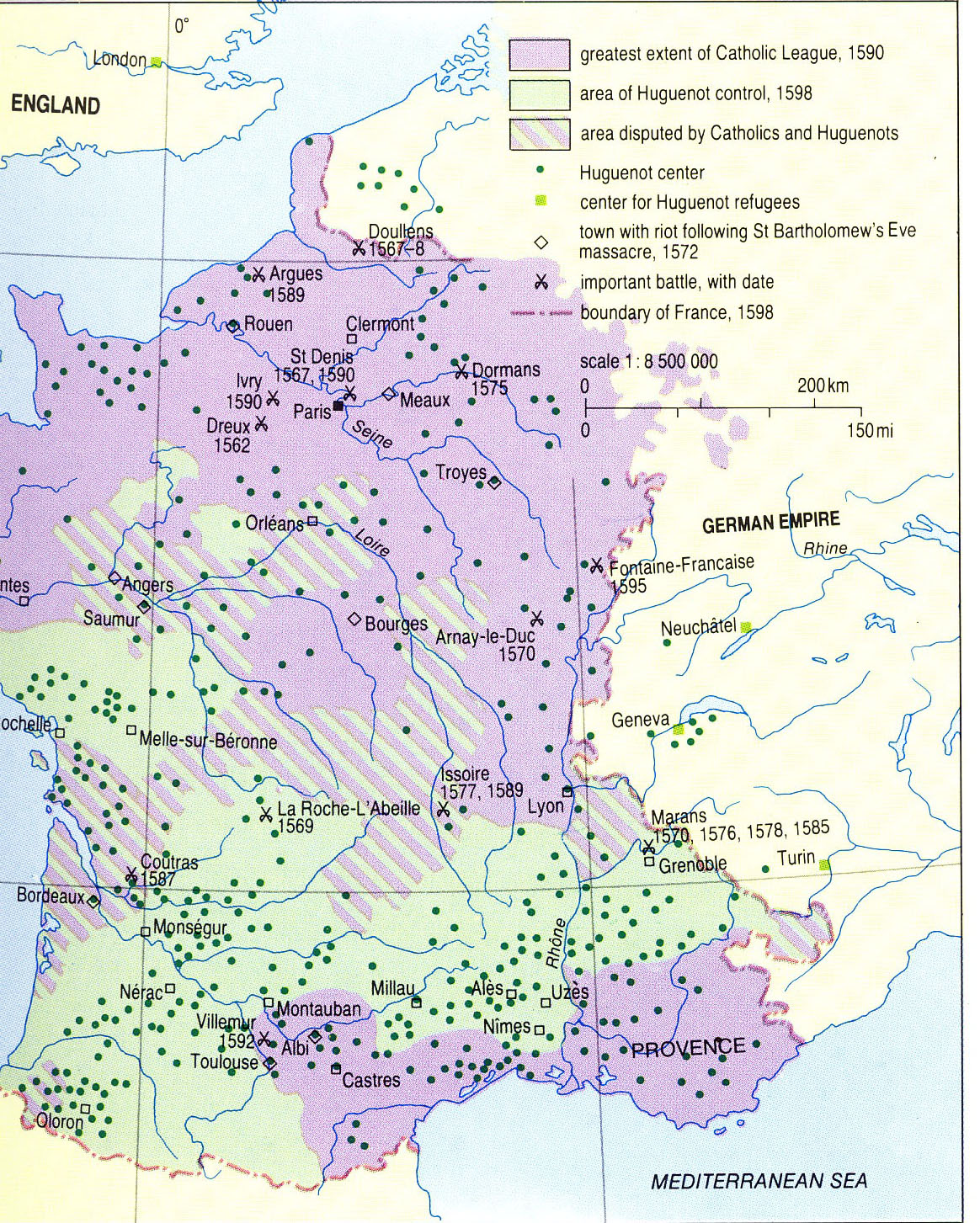
The Reformation had a profound effect on France. During the latter half of the 16th Century, Protesrtant and Huguenot communites are introduced and tranformed France's geography. They were especially active in the Rhone Valley, the Cevennes in the Southeast through Bearn, the Bordelais, Poitou, and Normandy in the Northwest. The Edict of Nantes, issued by Henri IV of Navarrre introduced religious toleration. It was later revoked by Louis XIV. |
|---|
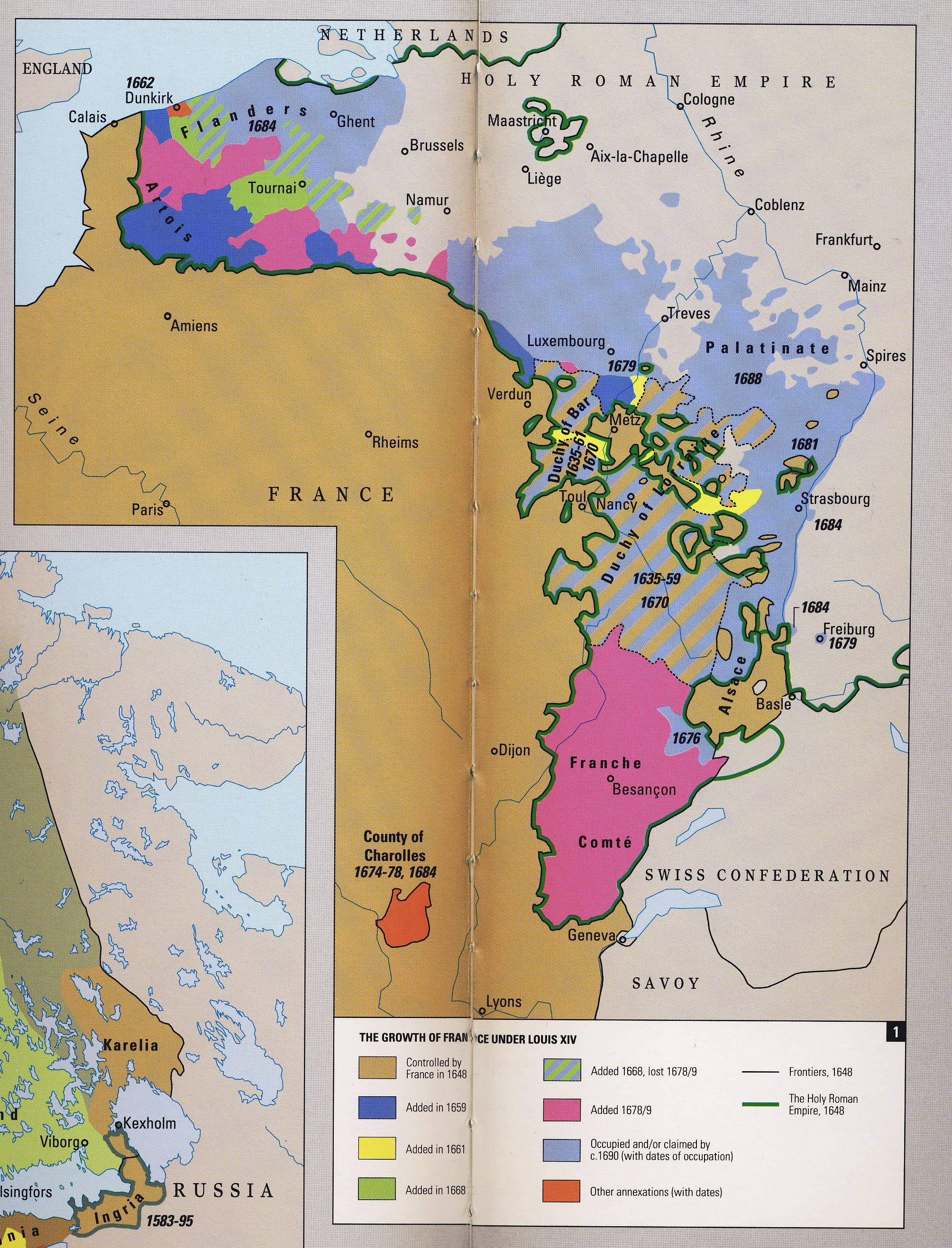
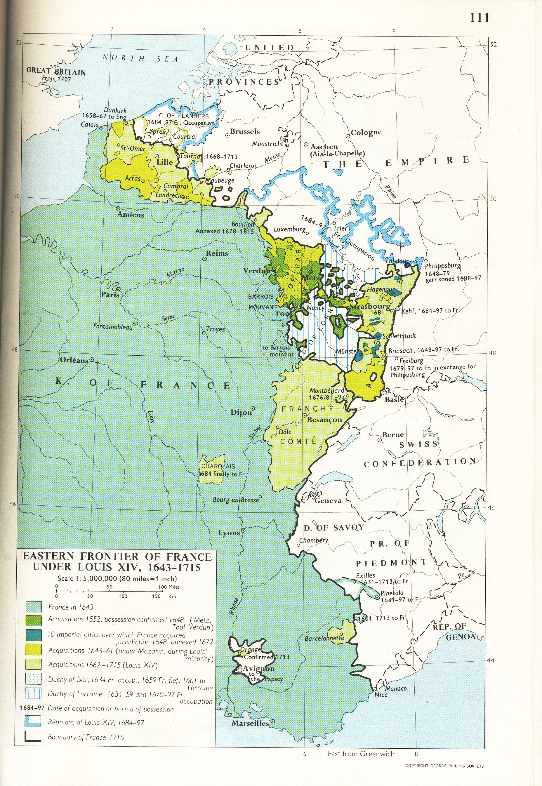
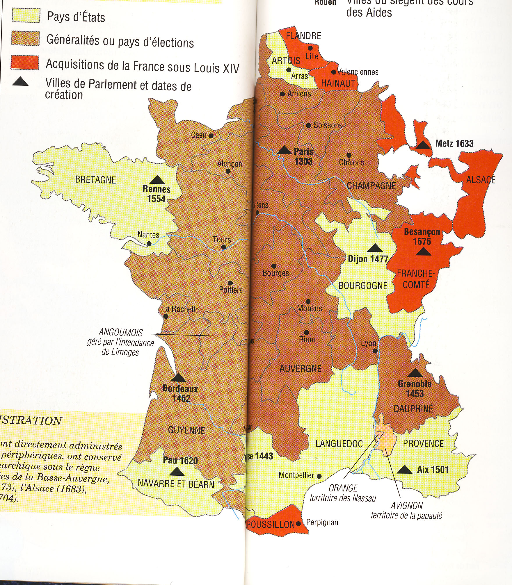
Frame 2: Mazarin
Caption: Mazarin's Conquests
Use map inventory numbers: EU20_88 EU20_72
The 17th Century marked the growth of ministerial power in the goverment. Cardinal Minister Mazarin controlled the ROYAL council 1642-61 while Louis XIV was still too young to RULE. gain full monarchial power. Mazarin extended the French borders during his period in power |
|---|
I SUGGEST COMBINING FRAMES 3 AND 4.
Frame 3: Expansion Under Louis XIV
Caption: War of Devolution
Use map inventory numbers: EU20_72 EU20_88
The War of Devolution |
|---|
Frame 4: Expansion Under Louis XIV
Caption: The Dutch War
Use map inventory numbers: EU20_72 EU20_88
The Dutch War was between 1672 and 1678, Louis XIV gained the Franche-Comte in the Southeast and lands in the North between Artois and Flanders by the Peace of Nijmegen. However, despite his gains he lost some land in the Spanish Netherlands that had been previously gained during the War of Devolution. |
|---|
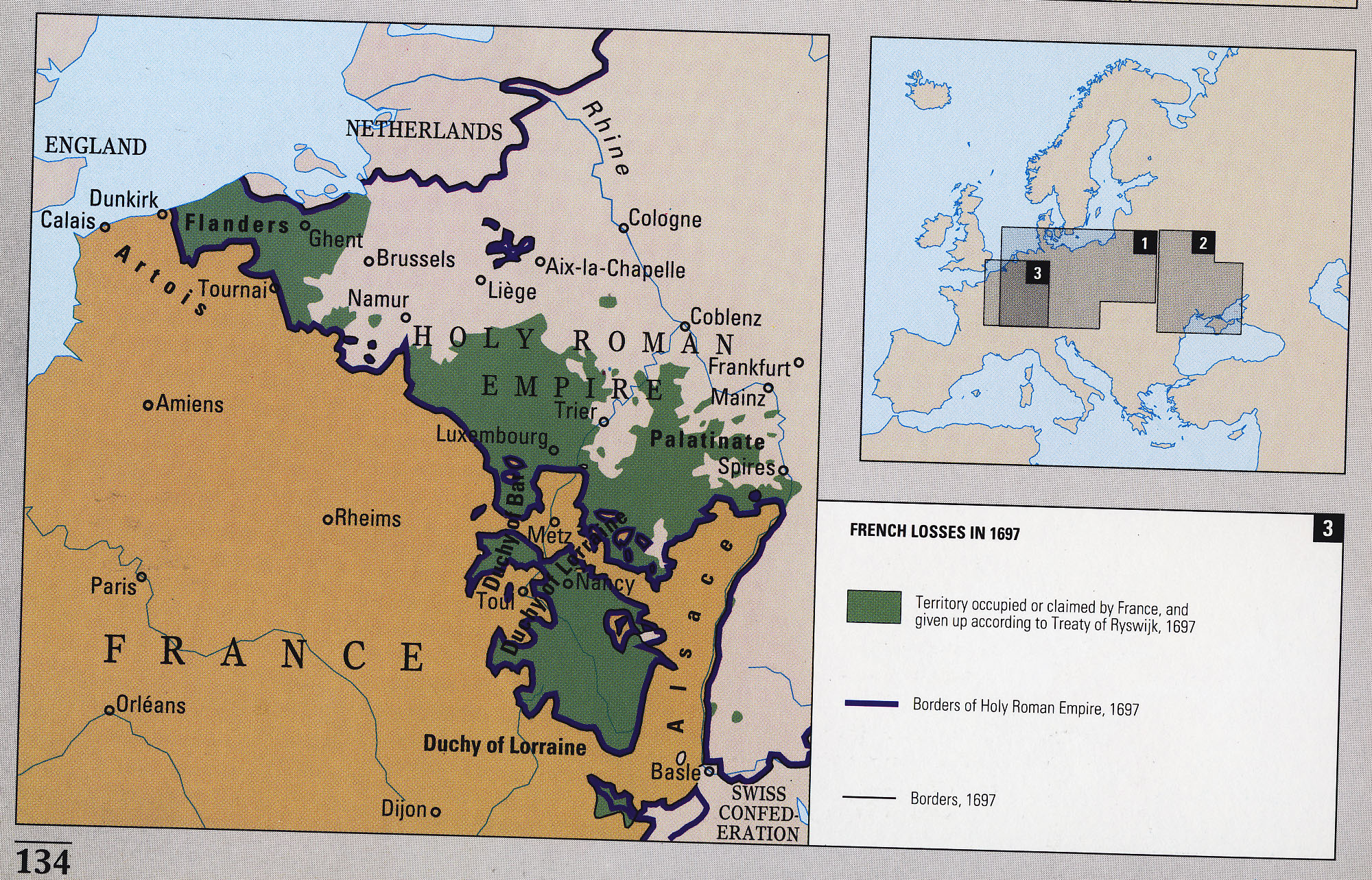
Frame 5: Losses Under Louis XIV
Caption: The Nine Years War
Use map inventory numbers: EU20_90 EU20_72
During the Nine Years War, |
|---|
Frame 6: Louis XIV's Final War
Caption: The War of Spanish Succession
Use map inventory numbers: EU20_72, EU20_88 EU20_01 EU20_04
DURING the War of Spanish Succession, |
|---|
Section 4:
Title: Revolutionary France
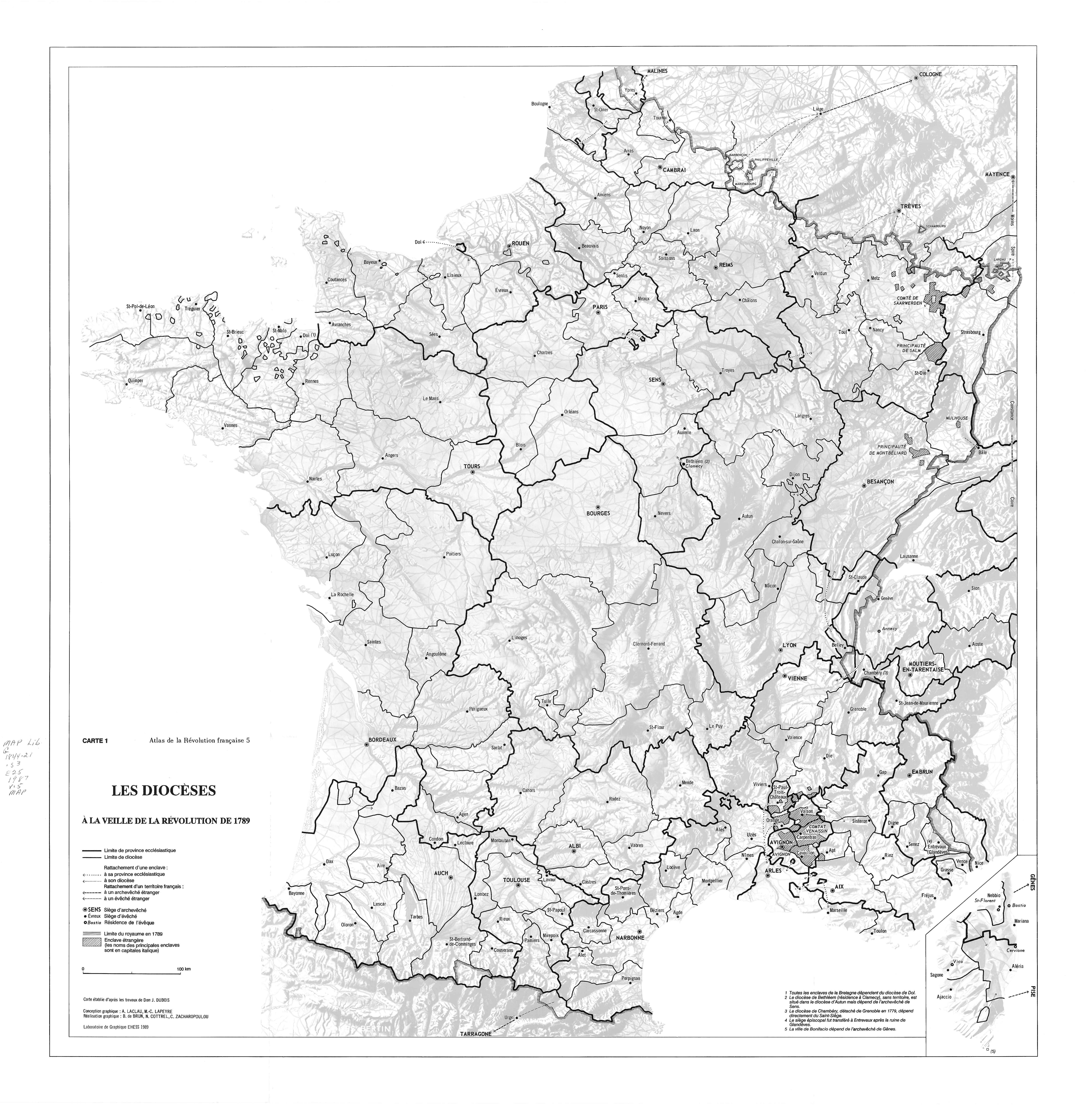
Frame 1: Religion
Caption: Nationalization of Church Lands
Use map inventory numbers: EU20_12, EU20_24
When France was on the cusp of a revolution, religion proved to still be a major source of conflict. In November 1789, the Civil Constitution of the Clergy introduced an ecclesiastical reorganization which nationalized church lands. It divided French priests and believers, sketching out a religious geography. |
|---|
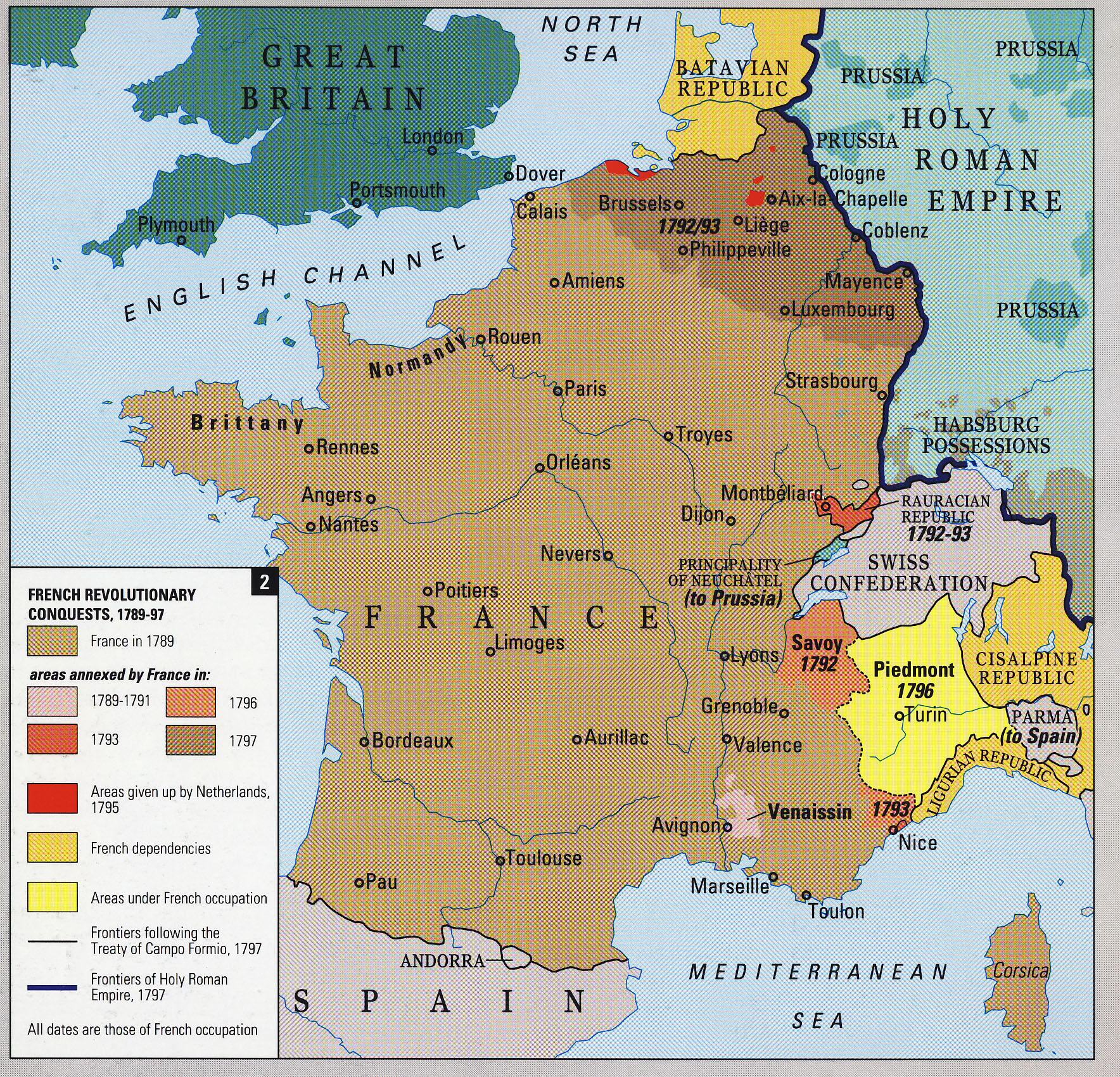
Frame 2: Expansion
Caption: Border Changes During the French Revolution
Use map inventory numbers: EU20_12, EU20_93
The Committee of Public Safety formed in April 1793 and cleared French soil of foreign armies by mid-1794 which allowed French power to spread. France annexed new territories in Southeastern France and occupied other regions in the same area. It also set up puppet regimes in neighboring states, and by the late 1790s France had become "La Grande Nation". |
|---|
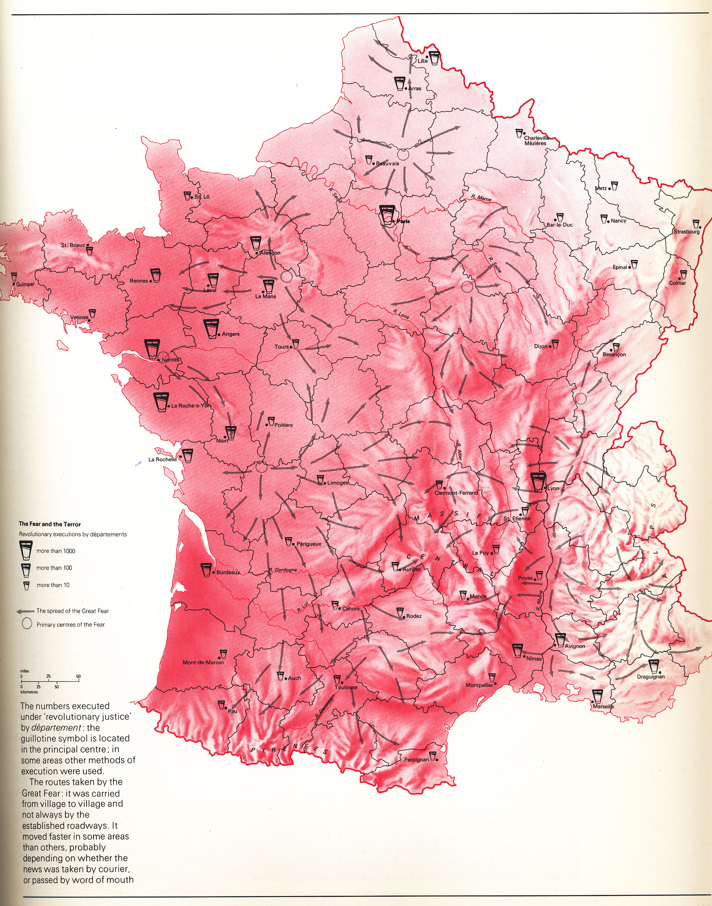
Frame 3: The Terror
Caption: Executions Throughout Revolutionary France
Use map inventory numbers: EU20_99
The guillotine was introduced as a more humane way of execution during the French Revolution. It was used throughout France as the most common way of executing those condemned during the Reign of Terror between 1792 and 1794. The city of Paris had the most executions, as did other big cities such as Lyon, Nantes, Angers, and La Roche-s-Yon. Executions were also frequent throughout areas in the Northwest and Southeast. |
|---|
Section 4:
Title: Napoleonic Europe
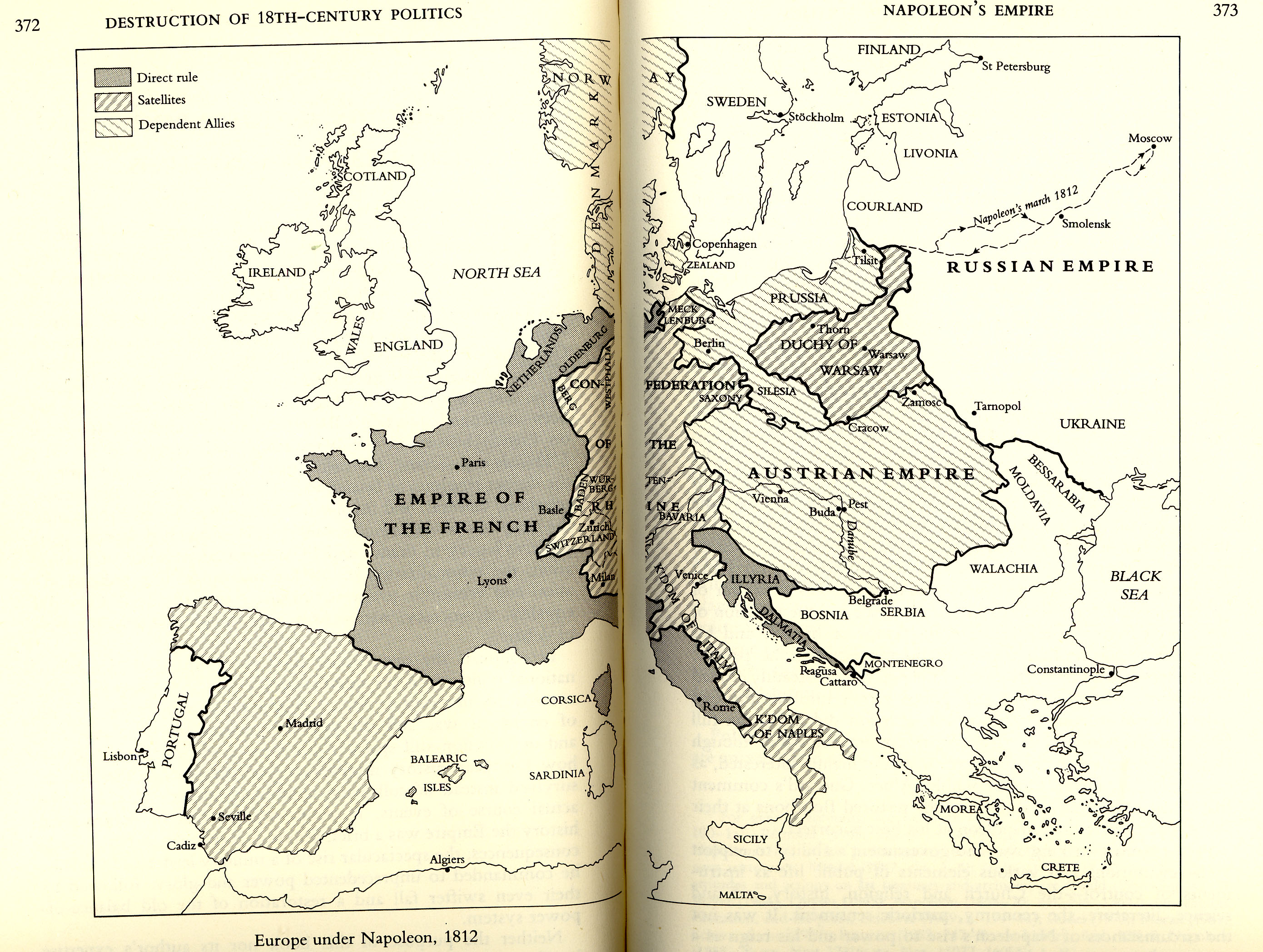
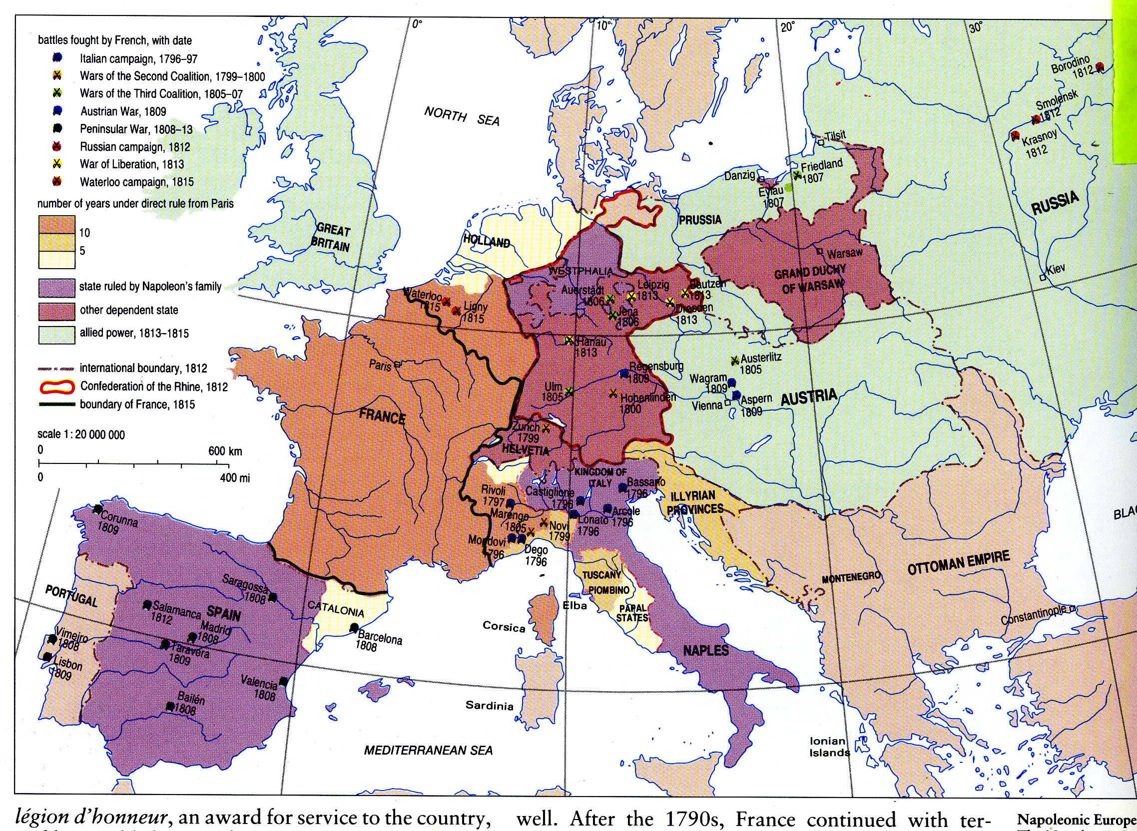
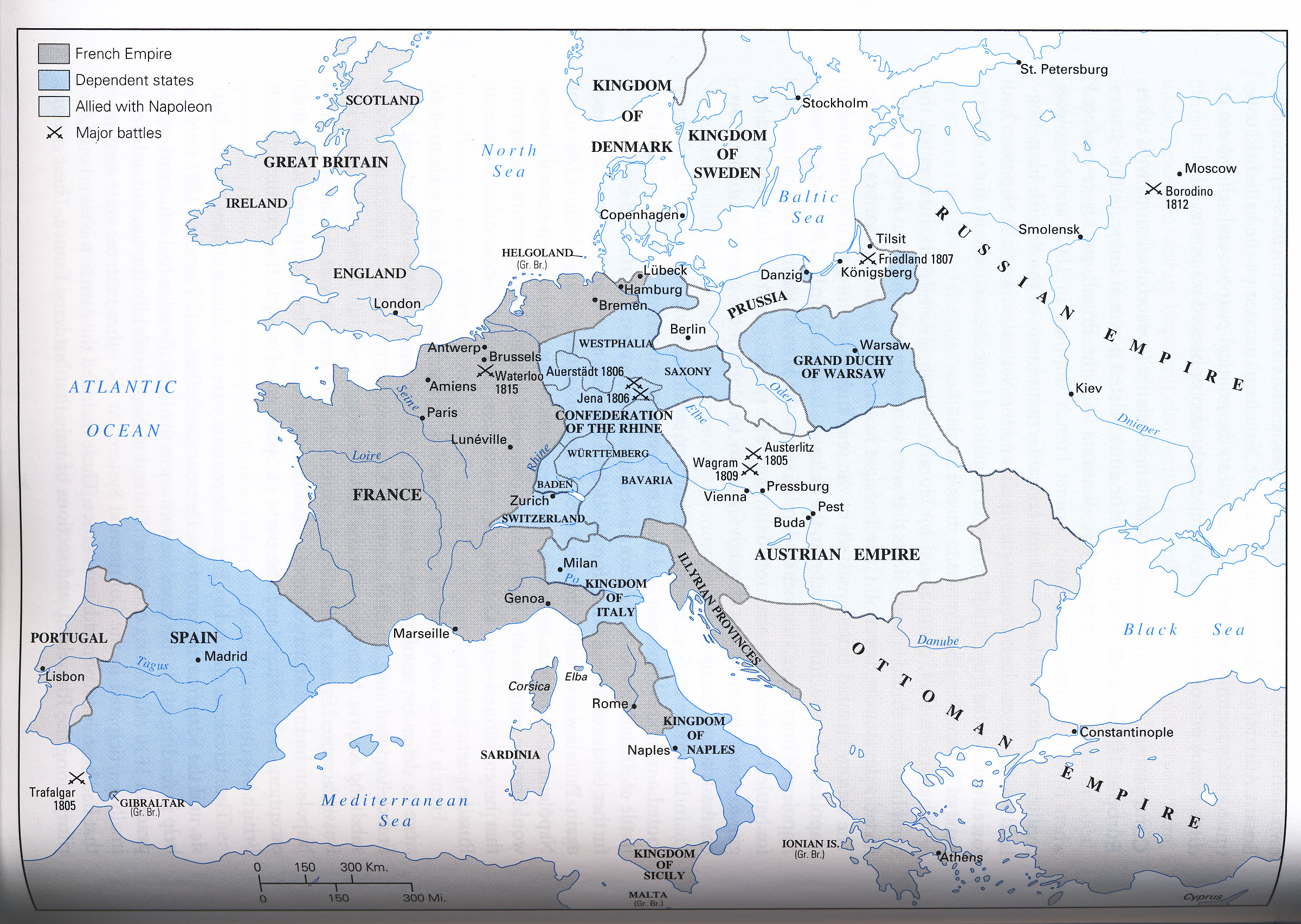
Frame 1: Napoleon's Beginnings
Caption: Napoleon as Emperor of France
Use map inventory numbers: EU20_15 EU20_23 EU20_97
In 1804, Napoleon deemed himself Emperor of France. He rapidly began French expansion by conquering most of central Europe. Direct rule over his Empire extended along the Eastern coast of Italy including Rome, the Illyrian Provinces even farther East, and the Netherlands in the North. |
|---|
Frame 2: The French Empire
Caption: Dependant States of the Empire
Use map inventory numbers: EU20_15 EU20_97
Napoleon's gains were divided into the French Empire. Dependant states, such as Northern Italy, were ruled by appointed members of the Bonaparte family. Not too soon after, he formed the Grande Duchy of Warsaw and placed it under the rule of one of his vassals, the German king of Saxony. His final designation to one of his foreign satellites was the appointment of his brother Joseph as king of Spain in 1808, who was later deposed in 1813. |
|---|
Frame 3: The Confederation of the Rhine
Caption: Napoleon's Unique Dependent Satellite
Use map inventory numbers: EU20_16 EU20_97
Western German States of the Holy Roman Empire allied with France against Austria. Napoleon organized them into the Confederation fo the Rhine, a loose association of roughly sixteen German states. He appointed himself as "Protector", unlike the rest of his dependent satellites which he appointed rulers to. |
|---|
Frame 4: Congress of Vienna
Caption: The Dissolution of Napoleonic Europe
Use map inventory numbers: EU20_14 EU20_92
Though Napoleon wasn't completely defeated until the battle of Waterloo in June 1815, the Congress of Vienna met in 1814 and decided the fate of European borders. The conference of ambassadors from important European states settled the border issues that arose from the French Revolutionary and Napoleonic wars, as well as the dissolution of the Holy Roman Empire. France lost several territories along the Rhine, such as Savoy. |
|---|
Frame 5: 19th Century France
Caption: Second Colonial Empire
Use map inventory numbers: EU20_20 EU20_21
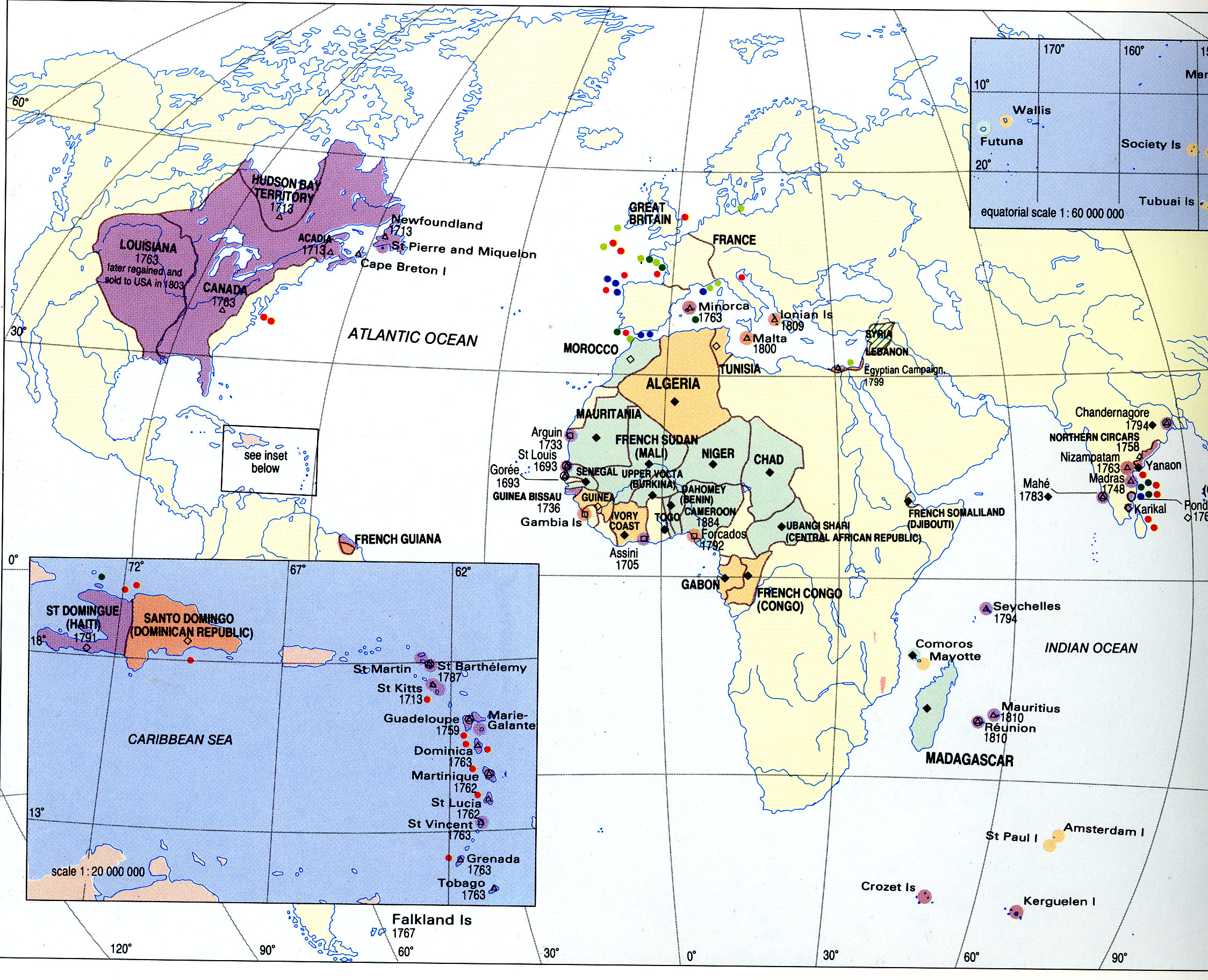
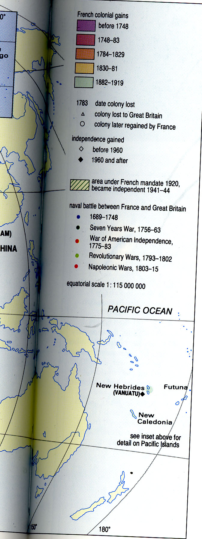
During the 19th Century, a second colonial empire was attempted to expand beyond even that of Napoleon's. By the latter half of the century, France had gained territories in Northwestern Africa and control over the Dominican Republic. |
|---|
Section 4:
Title: 20th Century France
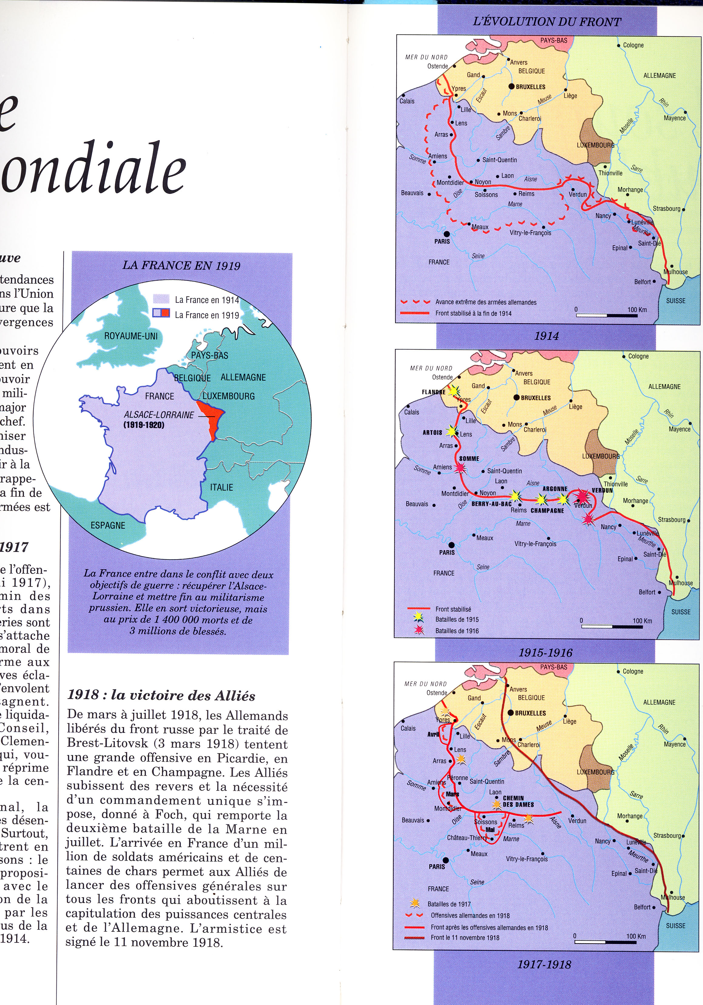
Frame 1: World War I
Caption: France During the Great War
Use map inventory numbers: EU20_27 EU20_28 EU20_77
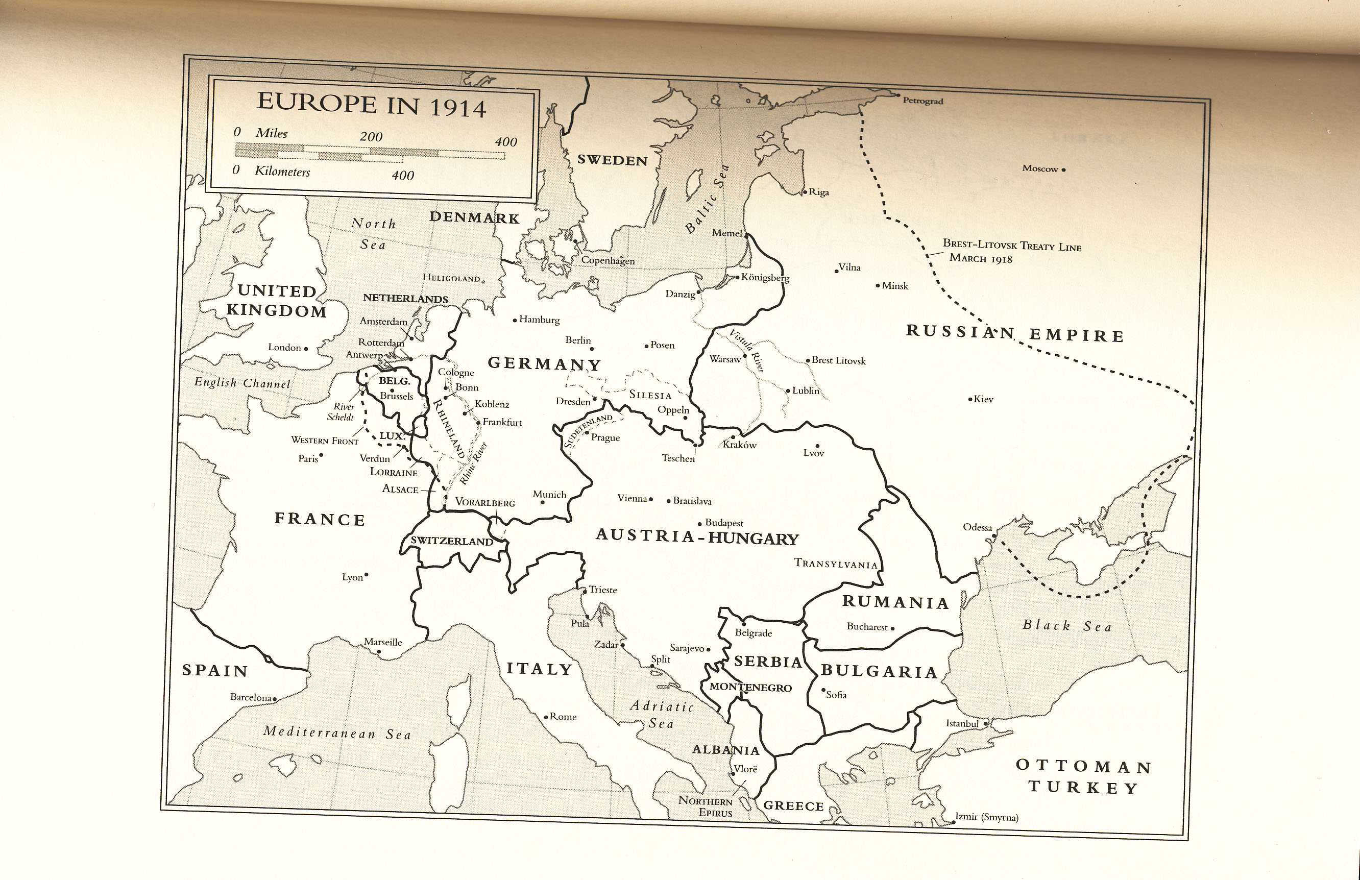
In August 1914, Germany invaded France through Belgium, a neutral state, marking French involvment in the First World War. It's effects on France's population were devestating. Between 1914 and 1917, the Germans occupied and controlled the Western Front of France along the Rhine. |
|---|
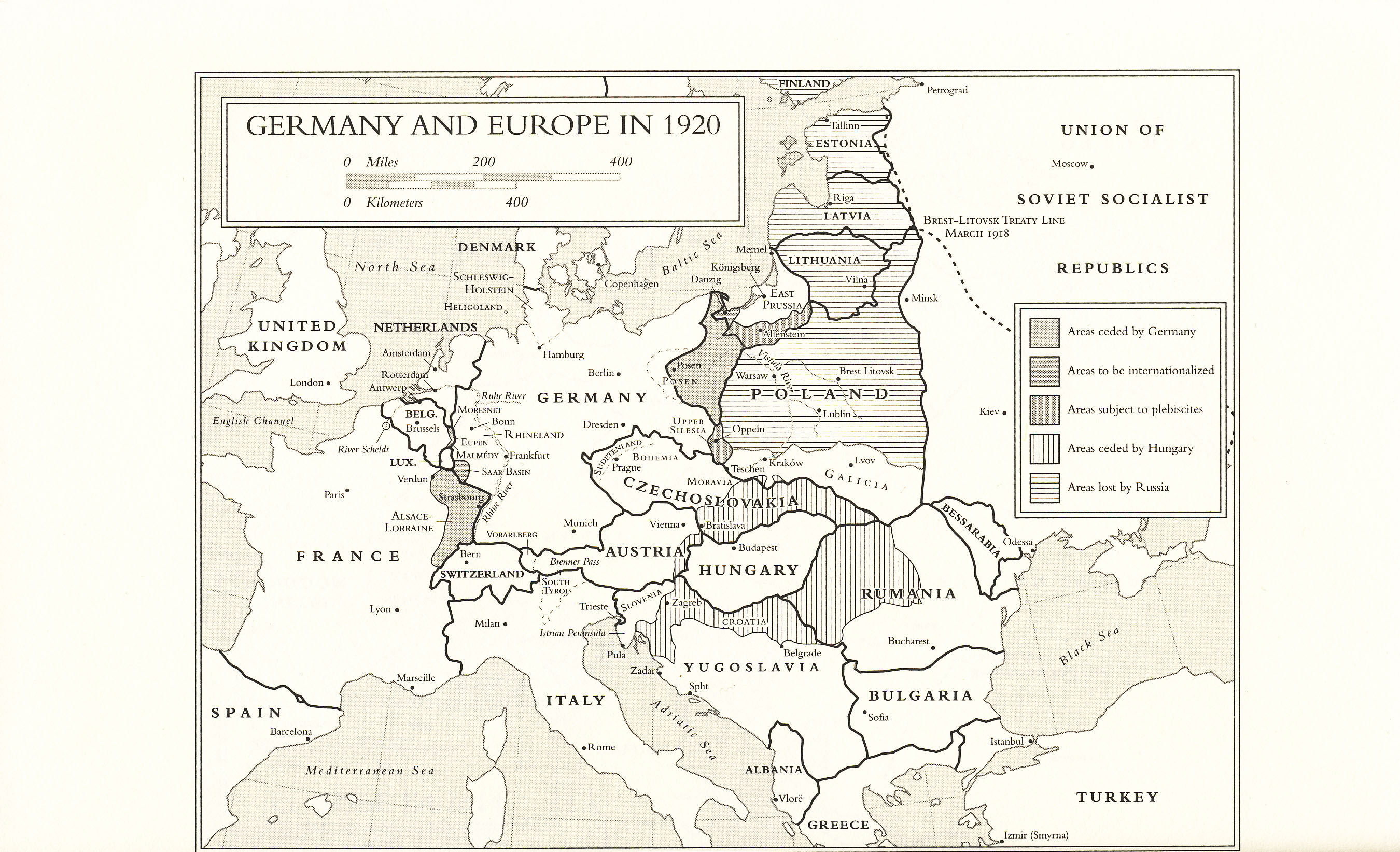
Frame 2: Versailles Peace Conference
Caption: France After the War
Use map inventory numbers: EU20_27, EU20_78, EU20_96
It wasn't until the Versailles Peace Conference in 1919 that ensured German reparations and the demilitarization of the Rhineland. This created the Maginot line along the Western border and granted France control of Alsace-Lorraine once again. |
|---|
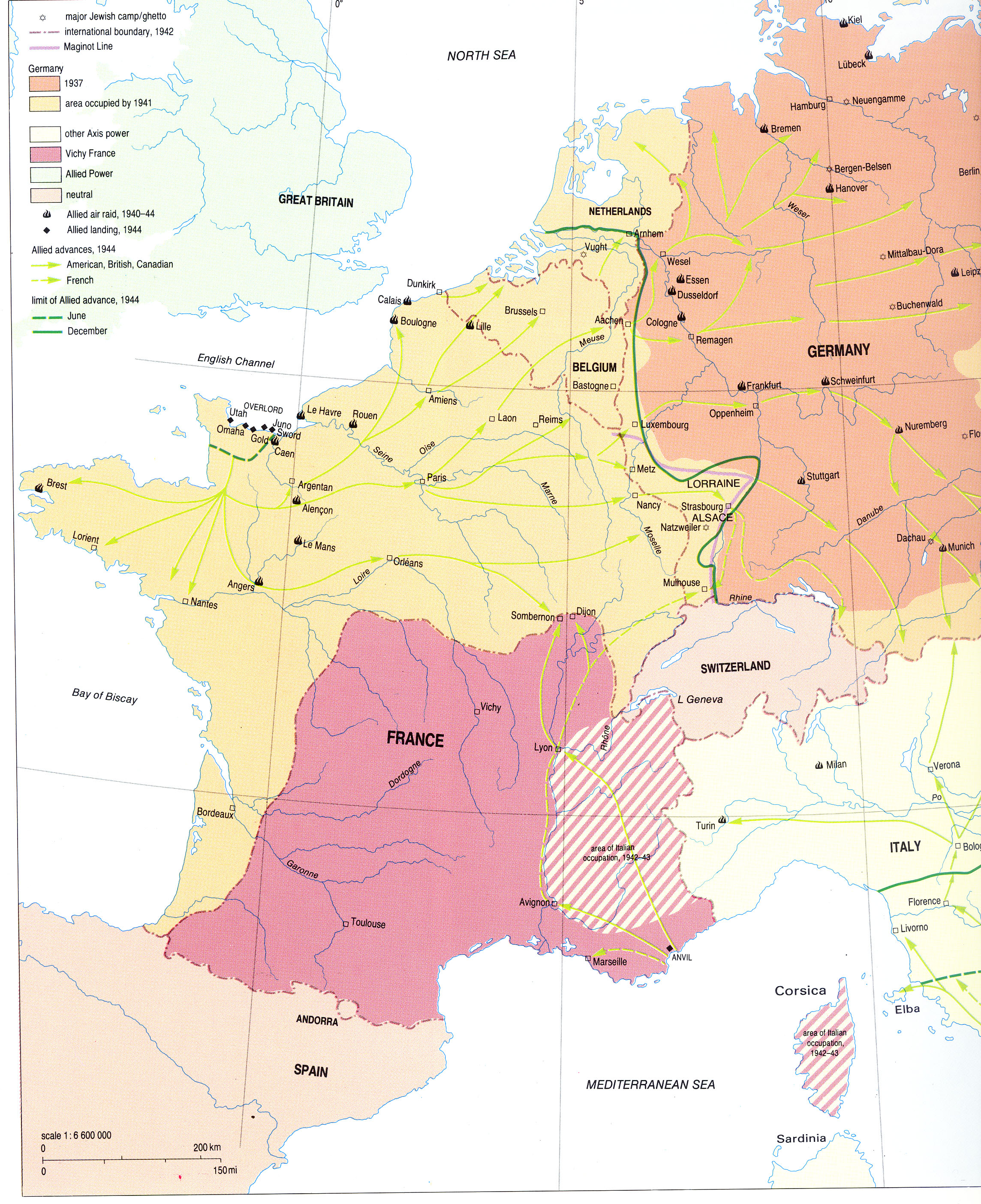
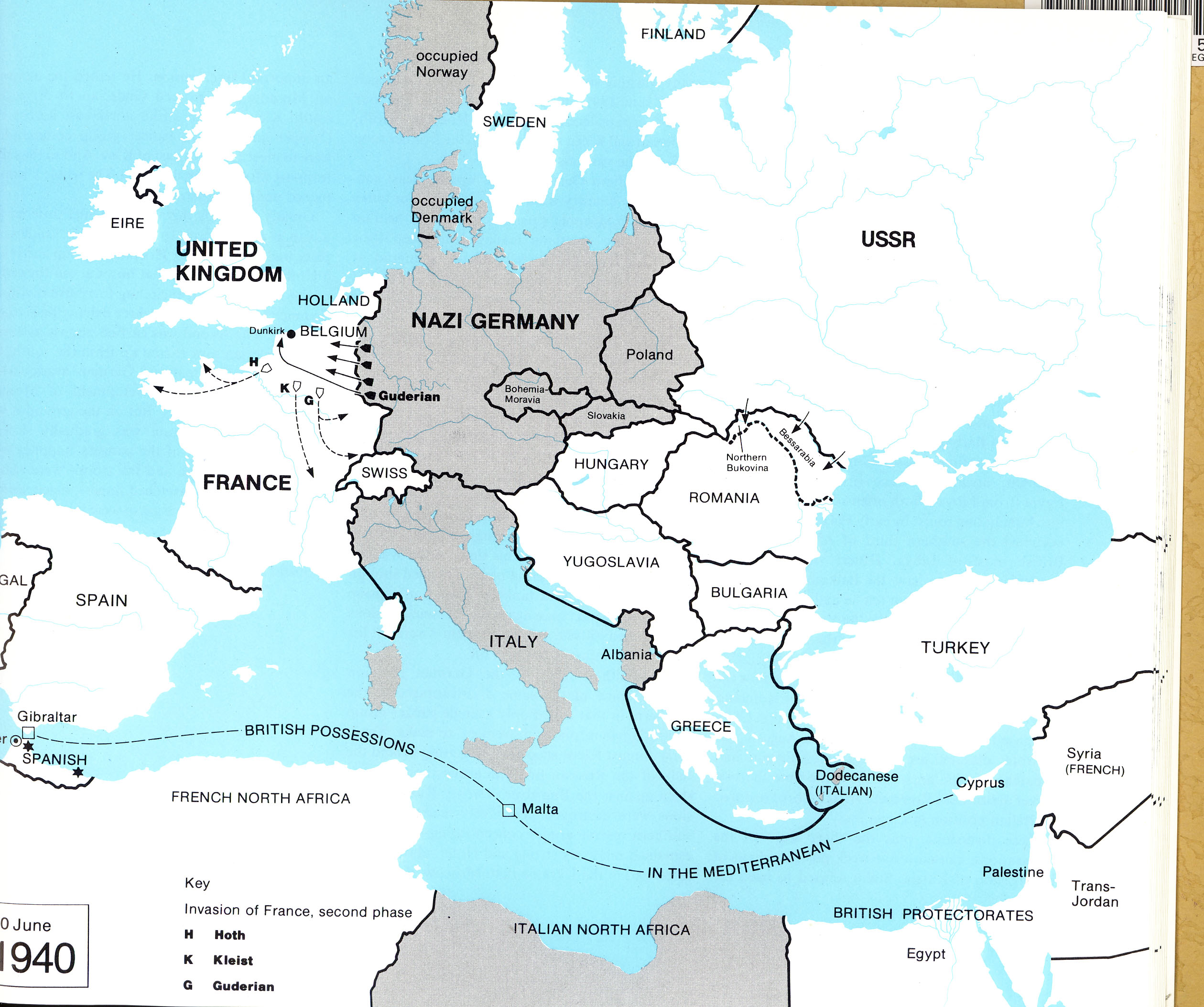
Frame 3: World War II
Caption: Germans Invade France
Use map inventory numbers: EU20_32 EU20_39
In 1940, the Nazi Germans charged through the Maginot line and took Paris in June. Alsace and Lorraine were restored the Reich. By 1941, Germany occupied all of Northern France as well as the Western coast all the way down to the Spanish border. |
|---|
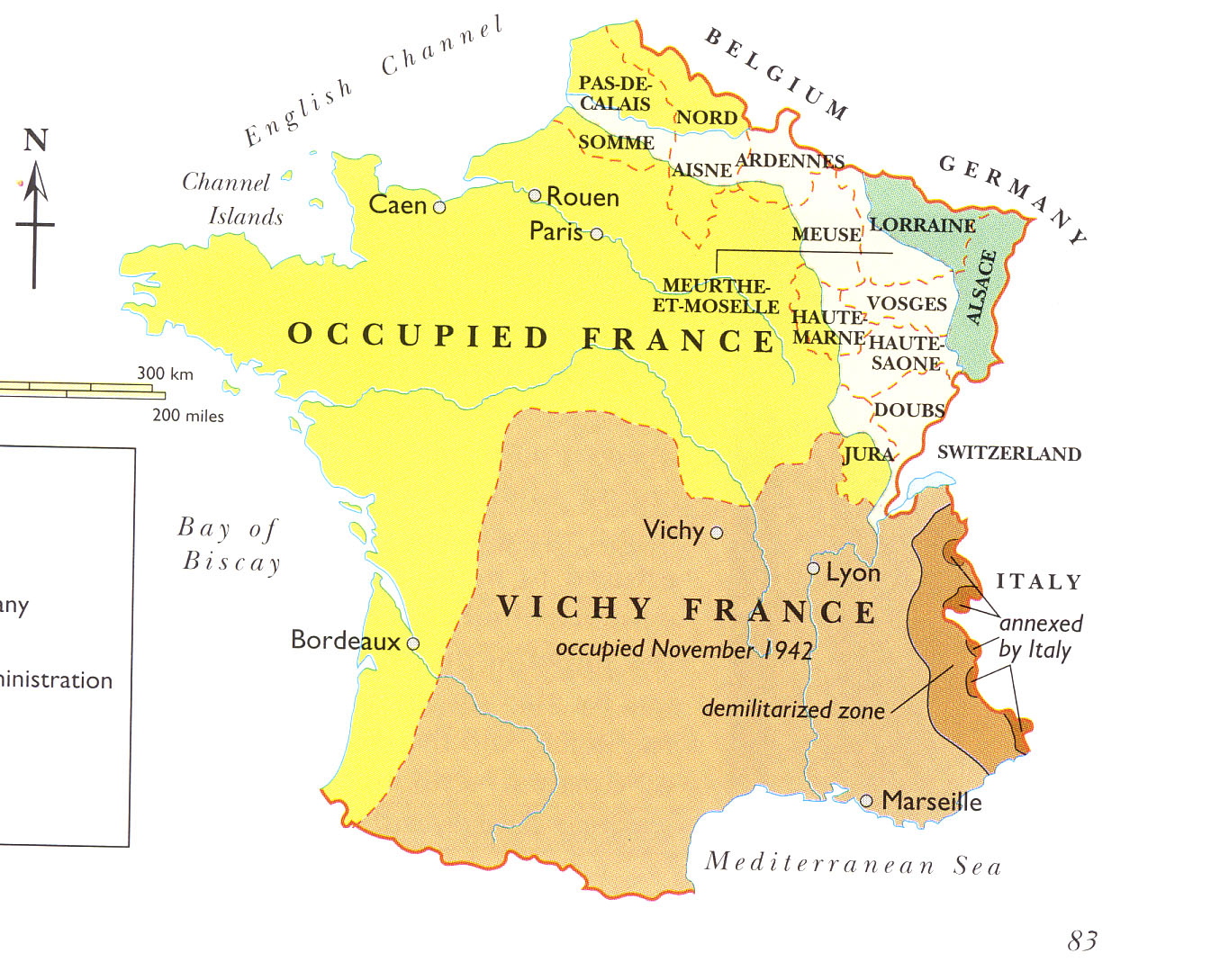
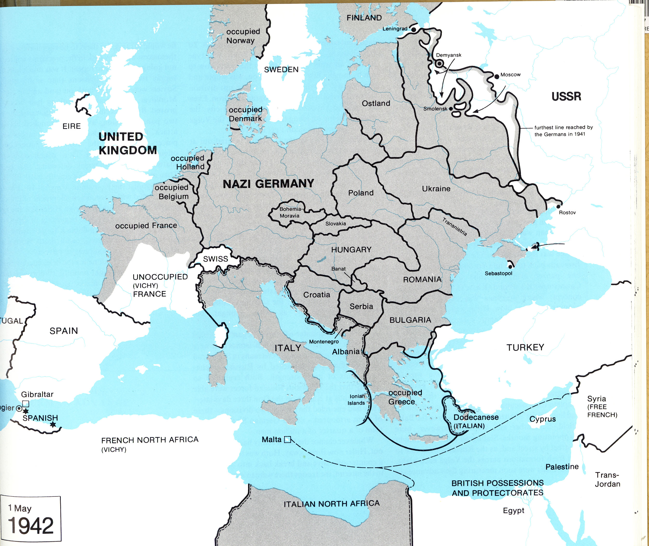
Frame : Vichy: The New France
Caption: France Under Nazi Occupation
Use map inventory numbers: EU20_37 EU20_41
After the invasion, Vichy became the new "capital" of France while Southern France remained in a state of chaos. In 1942, Germany invaded and occupied the Southern zone of France. Vichy was transformed into a Nazi Police state until 1944. |
|---|
Frame 5: End of WWII
Caption: Restoration of France
Use map inventory numbers: EU20_32
In June 1944, American Allies stormed the beaches of Normandy. This marked the end of Nazi domination and the allies took back Paris, the rest of France, and the territories of Alsace-Lorraine from the Germans. |
|---|