I am working on an NSF-funded collaborative study aimed at reconstructing the origins and early evolution of the Colorado River through study of the late Miocene to early Pliocene Bouse Formation, exposed discontinuously along the lower Colorado Riverr. This is a multi-institution collaboration with Laurie Crossey (Univ. New Mexico), Andy Cohen (Univ. Arizona), Karl Karlstrom (Univ. New Mexico), and USGS colleagues Kyle House, Ryan Crow, Keith Howard, Kris McDougall, and Sue Beard. Former UO graduate student Brennan O'Connell completed her MS degree in fall of 2016 and is now in the Ph.D. program at the University of Melbourne, Australia. Current UO graduate student Kevin Gardner has completed his second season of field work in the Palo Verde Mountains and is aiming to complete his MS thesis in summer 2019.
The Bouse Formation offers a superb opportunity to investigate the conditions and processes that culminated in integration of this iconic river system. Our understanding of how the Colorado River became linked to the Gulf of California depends on interpretation of the Bouse Formation, but there is no consensus on the depositional environments of this unit. Vigorous debate is focused on whether the southern Bouse accumulated in a marginal-marine estuary or a large inland lake that was isolated from the ocean. The marine-estuary hypothesis for the southern Bouse requires that the depositional region had subsided to sea level by ~5.5 Ma, and implies that the Colorado River was routed into its modern course by subsidence in a tectonic lowland at the north end of the Gulf of California rift. This hypothesis also requires that parts of the lower Colorado River corridor have undergone ~330 m of post-depositional uplift due to reversal in the direction of vertical crustal motions. The inland-lake hypothesis allows all of the Bouse deposits to have formed at their present elevation above sea level, and does not require any post-depositional uplift or reversal in vertical crustal motions through time. This hypothesis favors profound changes in regional climate, hydrology, and landscape evolution – not tectonic subsidence – as the primary drivers of river integration.
|
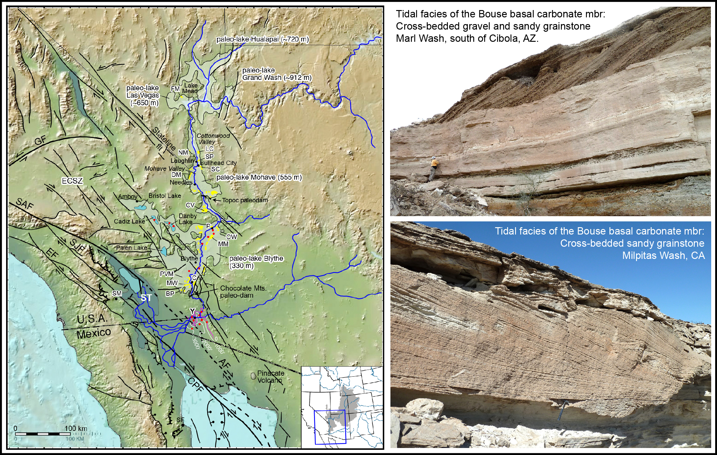
| Map of the lower Colorado River region showing major faults and inferred Bouse paleolakes. Surface exposures of the Bouse Formation are indicated in yellow. Paleolake maximum elevations are from Spencer et al. (2008; 2013). Red dots show wells that encountered Bouse Formation. Thin lines south of Yuma are subsurface structure contours showing elevation (in feet) of the top of the Bouse Formation (Olmsted et al., 1973). |
Our ongoing studies of process sedimentology and regional sequence stratigraphy (see below), integrated with micropaleontology (K. McDougall, 2016 GSA) and mixing models that explain published strontium isotopic ratios (Crossey et al., 2015), provide internally consistent and (we think) compelling evidence in support of the marine estuary hypothesis for the southern Bouse Formation. A paper on ostracodes and stable isotopes of the southern Bouse by Bright et al. (2016) supports the lacustrine interpretation, suggesting we have yet to fully understand and reconcile all the data sets. We also have new evidence for punctuated, start-and-stop delivery of sediment from the Colorado River to receiving marine basins in the northern Gulf of California during the first ca. 0.5 million years of the river's transit to the ocean (Dorsey et al., 2016 GSA). We are continuing work on our collaborative research into this intriguing problem.
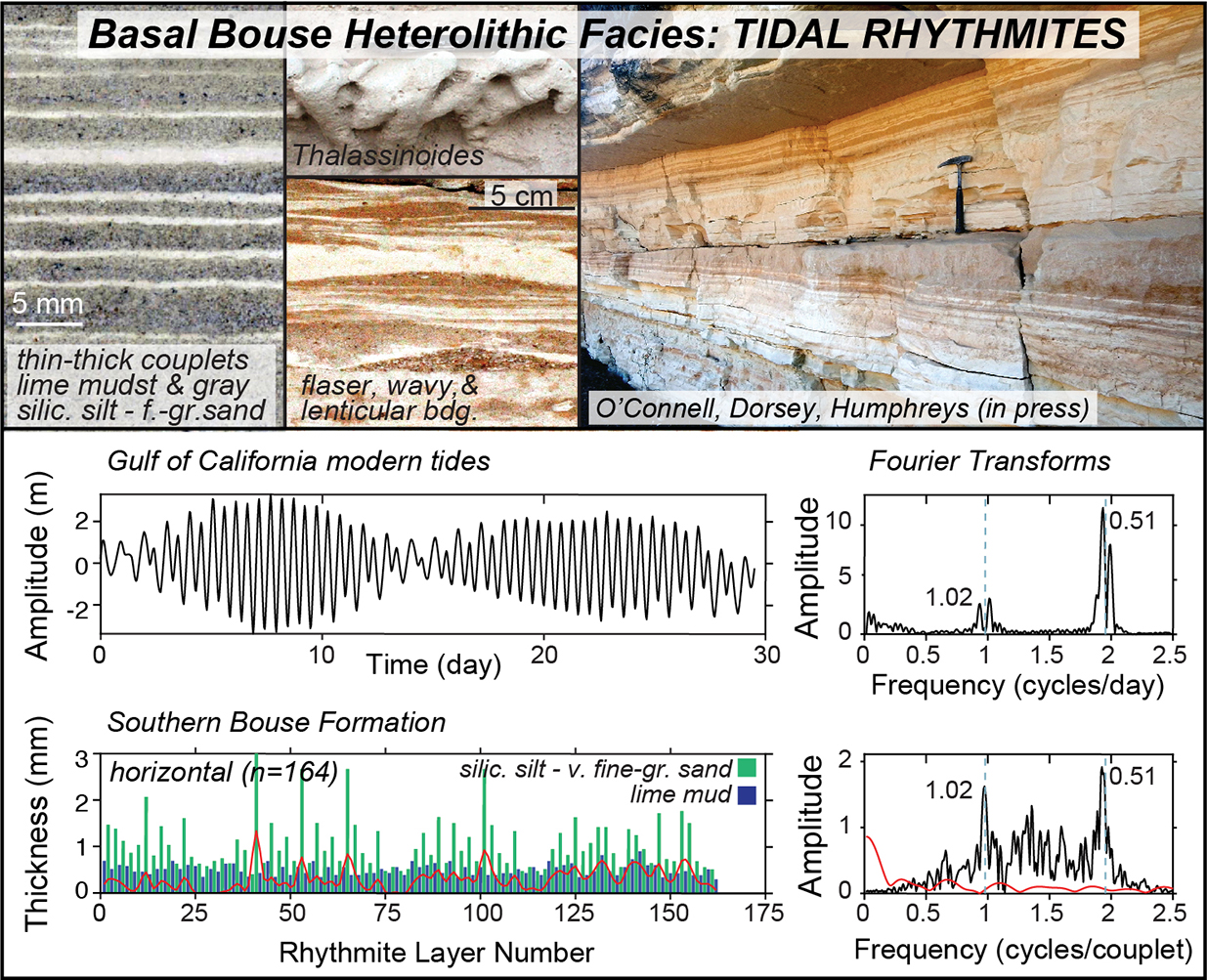
2017 paper: Tidal rhythmites in the southern Bouse Formation as evidence for post-Miocene uplift of the lower Colorado River corridor, by O'Connell, B., Dorsey R.J., and Humphreys E.D., 2017, Geology. v. 45 no. 2 p. 99-102.
See also O'Connell et al. 2016 GSA abstract, and 2016 Desert Symposium short papers, below.
Check out Mindy Homan's 2014 MS thesis on the southern Bouse Formation.
DORSEY, Rebecca J., Department of Earth Sciences, University of Oregon
MCDOUGALL, Kristin, U. S. Geological Survey, Flagstaff, AZ
O’CONNELL, Brennan, Department of Earth Sciences, University of Oregon
HOWARD, Keith A., U.S. Geological Survey, Menlo Park, CA
HOMAN, Mindy B., Department of Earth Sciences, Uof O (now at Devon Energy)
BYKERK-KAUFFMAN, Ann, California State University, Chico, CA
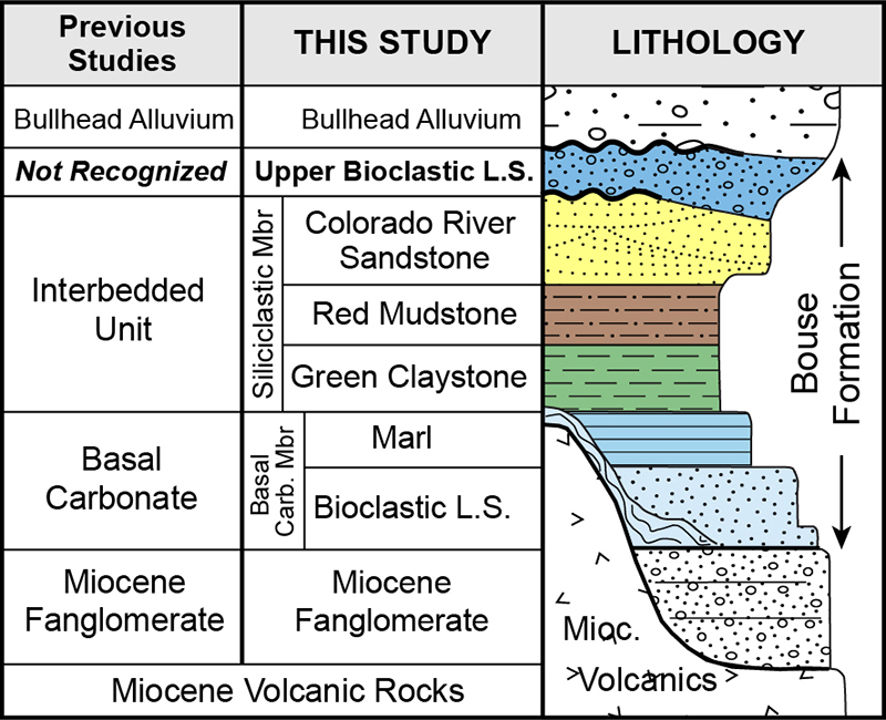 Late Miocene to early Pliocene deposits in the lower Colorado River (CR) corridor and western Salton Trough contain a record of sediment dispersal to the marine realm during the first ~0.5 m.y. of CR evolution. Abrupt first arrival of CR sand in the western Salton Trough is dated at ~5.3 Ma based on magnetostratigraphy and micropaleontology (Dorsey et al., 2007, 2011; this study), as recorded in sand-rich marine turbidites of the Wind Caves member of the Latrania Formation. The Wind Caves member is overlain by Coyote Clay, a regionally extensive marine claystone that records shut-down of sand delivery to the basin between ~5.1 and 4.8 Ma. Coyote Clay is overlain by a thick coarsening- and shallowing-up succession of marine sandstone and mudstone that records progradation of the CR delta and arrival of fluvial deposits (Palm Spring Group) at 4.25 Ma. Correlative deposits along the lower CR south of Blythe, CA, include: (1) Bouse Formation basal carbonate which accumulated in a transgressive intertidal to subtidal marine embayment at the north end of the Gulf of California; (2) Bouse green claystone coarsening up to thick cross-bedded CR channel sandstone that accumulated in the earliest through-flowing Colorado River; (3) upper Bouse bioclastic limestone, micrite, and fan gravels that formed in a large saline lake or marine estuary; and (4) cross-bedded pebbly sandstone (Bullhead Alluvium) that accumulated in the CR channel ca. 4.5-3.5 Ma (Howard et al., 2015). Bouse upper limestone records re-flooding of the lower CR valley after the river first flowed through it, and may correlate to limestone that overlies the 4.83-Ma Lawlor Tuff north of Buzzards Peak. Our stratigraphic synthesis suggests that dispersal of sand through the lower CR valley into the marine basin turned ON at ca. 5.3 Ma, turned OFF at ~5.1 Ma, and turned ON again at ~4.8-4.7 Ma. If the two stratigraphic records do not correlate to each other, the implied sequence of events would be more complex but not implausible. The discontinuous, start-and-stop history of sediment discharge is not predicted by existing models for CR initiation, and could have been controlled by variations in sediment discharge from the upper catchment (Colorado Plateau), changes in eustatic sea level, and/or changes in rate of fault-controlled subsidence along the lower CR corridor.
O'CONNELL, Brennan; DORSEY, Rebecca J.; and HUMPHREYS, Eugene D., Department of Earth Sciences, University of Oregon, Eugene, OR
Ongoing debate over depositional paleoenvironments of the late Miocene to early Pliocene Bouse Formation obscures our understanding of the timing and magnitude of regional uplift, as well as the conditions and processes that were active during initiation and early evolution of the Colorado River. Here we present new sedimentologic and statistical evidence for a strong tidal influence on deposition of the southern Bouse Formation in the Blythe basin. Abundant tidal lithofacies include: (1) matted sandy lime mudstone with reed and grass imprints; (2) heterolithic lime mudstone, wackestone, packstone, and grainstone with flaser, wavy, and lenticular bedding; (3) cross-bedded sandy grainstone with common reactivation surfaces; and (4) barnacle-oncoid grainstone with sigmoidal bundles and complex bedding. Systematic alternation of relatively thick and thin layers strongly suggests a mixed predominantly semidiurnal tidal depositional environment, and Fourier analysis highlights the cyclic, non-random nature of thickness trends. These observations indicate a pre-Colorado River tidal setting for the southern Bouse Formation at the north end of the Gulf of California marine oblique-rift basin. Deposition at sea level requires at least ~330 m of regional uplift in the lower Colorado River and western Colorado Plateau region during the past ca. 5.0-5.5 my.
Here are some short papers presented by our group at the 2017 Desert Symposium (Zzyzx, CA) - "ECSZ Does It" |
|
This and previous years' Desert Symposium volumes can be found here. Many thanks to our good friend and tireless volume editor, Bob Reynolds! |
Crossey, L.C., Karlstrom K.E., Crow R.S., Ferguson, C., and Dorsey, R.J. (2017) Towards a depositional model for travertines of the Bouse Formation: examples from the southern Blythe Basin. In: Reynolds, R.E. (Ed.), 2017 Desert Symposium Field Guide and Proceedings, California State University Desert Studies Center, Zzyzx, CA, p. 174-179.
Dorsey, R.J., O’Connell, B., Homan, M., and Bennett, S.E.K. (2017) Influence of the Eastern California Shear Zone on deposition of the Mio-Pliocene Bouse Formation: insights from the Cibola area, Arizona. In: Reynolds, R.E. (Ed.), 2017 Desert Symposium Field Guide and Proceedings, California State University Desert Studies Center, Zzyzx, CA, p. 150-157.
Karlstrom, K.E., Liu, L., Zhou, Q., Crossey, L.C., Thacker, J.O., Crow, J.R., and Beard, L.S. (2017) Mechanisms for post-Bouse (post-5 Ma) deformation in the lower Colorado River region. In: Reynolds, R.E. (Ed.), 2017 Desert Symposium Field Guide and Proceedings, California State University Desert Studies Center, Zzyzx, CA, p. 145-149.
Thacker, J.O., Karlstrom, K.E., Crossey, L.C., Crow, J.R., Beard, and Dorsey, R.J. (2017) Hypothesis for post-Bouse distributed deformation of the Lower Colorado River corridor. In: Reynolds, R.E. (Ed.), 2017 Desert Symposium Field Guide and Proceedings, California State University Desert Studies Center, Zzyzx, CA, p. 158-164.
Here are some short papers presented by our group at the 2016 Desert Symposium (Zzyzx, CA) - "Going LOCO" |
|
This and previous years' Desert Symposium volumes can be found here. Many thanks to our good friend and tireless volume editor, Bob Reynolds! |
Beard, L.S., Haxel, G.B., Dorsey, R.J., McDougall, K.A., and Jacobson, C.E. (2016) Late Neogene deformation of the Chocolate Mountains Anticlinorium: Implications for deposition of the Bouse Formation and early evolution of the Lower Colorado River. In: Reynolds, R.E. (Ed.), 2016 Desert Symposium Field Guide and Proceedings, California State University Desert Studies Center, Zzyzx, CA, p. 176-184.
Bennett, S.E.K., Darin, M.H., Dorsey, R.J., Skinner, L.A., Umhoefer, P.J., and Oskin, M.E. (2016) Animated tectonic reconstruction of the Lower Colorado River region: implications for Late Miocene to Present deformation. In: Reynolds, R.E. (Ed.), 2016 Desert Symposium Field Guide and Proceedings, California State University Desert Studies Center, Zzyzx, CA, p. 73-86.
Bright, J., Cohen, A.S., and Pearthree, P.A. (2016) Stable oxygen (δ18O) isotope data from paired inorganic calcite and ostracode valve analyses suggest a lacustrine origin for the southern Bouse formation, southwestern AZ and southeastern CA. In: Reynolds, R.E. (Ed.), 2016 Desert Symposium Field Guide and Proceedings, California State University Desert Studies Center, Zzyzx, CA, p. 123-131.
Crossey, L.C., Karlstrom K.E., Crow R.S., House, P.K., and Pearthree, P.A. (2016) Travertines of the Bouse Formation. In: Reynolds, R.E. (Ed.), 2016 Desert Symposium Field Guide and Proceedings, California State University Desert Studies Center, Zzyzx, CA, p. 166-170.
Dorsey, R.J., O’Connell, B., Homan, M., and Howard, K.A. (2016) Upper limestone of the southern Bouse Formation: Evidence for unsteady origins of the Colorado River. In: Reynolds, R.E. (Ed.), 2016 Desert Symposium Field Guide and Proceedings, California State University Desert Studies Center, Zzyzx, CA, p. 145-153.
Howard, K.A., Malmon, D.V., Hillhouse, J.W., Dorsey, R.J., Crow R.S., and House, P.K. (2016) Magnetostratigraphic constraints on the Bouse Formation in the Blythe Basin: Existing evidence. In: Reynolds, R.E. (Ed.), 2016 Desert Symposium Field Guide and Proceedings, California State University Desert Studies Center, Zzyzx, CA, p. 97-100.
Karlstrom, K.E., Crossey, L.C., Crow R.S., and Dorsey, R.J. (2016) New directions in research on the Bouse Formation and the origins of the lower Colorado River. In: Reynolds, R.E. (Ed.), 2016 Desert Symposium Field Guide and Proceedings, California State University Desert Studies Center, Zzyzx, CA, p. 91-96.
O’Connell, B., and Dorsey, R.J. (2016) Depositional paleoenvironments of the basal carbonate member of the southern Bouse Formation, Cibola, Arizona. In: Reynolds, R.E. (Ed.), 2016 Desert Symposium Field Guide and Proceedings, California State University Desert Studies Center, Zzyzx, CA, p. 160-165.
O’Connell, B., Dorsey, R.J., Homan, M., Gootee, B.F., and House, P.K. (2016) Structural controls on stratigraphic architecture of the southern Bouse Formation near Cibola, Arizona. In: Reynolds, R.E. (Ed.), 2016 Desert Symposium Field Guide and Proceedings, California State University Desert Studies Center, Zzyzx, CA, p. 171-175.
This page was last updated March 2019, by Becky Dorsey.