
|
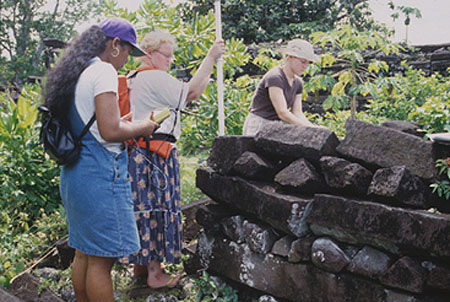
| Southeast side of tomb enclosure at Nanimwinsapw site. Ray Ladore observes the wall construction from inside the enclosure. Photo: W.S.Ayres |
The training project in 1998 and 1999 included site definition and
feature descriptions at a large residential complex at Imwinsapw, Sokehs, a traditionally
important area. This extensive architectural site has numerous stone features such as paved
walkways, enclosures, house foundations, and ritual architecture extending from the shoreline of
Sokehs Island well into the interior. In addition to dozens of prehistoric features, several
of which were identified and mapped, the area also includes extensive Japanese fortifications
of stonewalls, pits, and gun emplacements dating to the 1940s and a German colonial period road
dating to the early 20th century. Both prehistoric and historic features were described and
mapped in an effort to provide basic documentation in this area before additional construction
development damages archaeological features.
Southeast side of tomb enclosure at Nanimwinsapw site. Ray
Ladore observes the wall construction from inside the enclosure. Photo: W.S.Ayres
In 1999, we did clearing and mapping of the major tomb in the site complex at Nanimwinsapw; this is a 15 by 20m stone walled enclosure with a central tomb platform that sits at the shoreline and extends out into the mangrove swamp.
Other training projects included additional GPS point survey locations and detailed mapping in
the well-known Nan Madol site on Pohnpei's east coast. As well, we developed a plan to work
with the HPO to create a comprehensive site record database. Thus, the interaction involved
both collaborative archaeological research and cultural resource management.
Recording mapping data points at Nan Madol using Global
Positioning System unit. Kristin Vanwert (right, University of Montana) takes notes while
Lisa Andon holds the recording antenna, and Derelisa Ardos (left) reads the instrument panel
screen reporting the location. Photo: W.S.Ayres
Acknowlegements:
Emensio Eperiam, Chief, Historic Preservation Office, Pohnpei State, Federated States of
Micronesia, was the key administrator on Pohnpei. David Panuelo, Head of Lands and Natural
Resources for Pohnpei State and Condios Cornelios, Head of the Land Surveying
Office, were instrumental in providing resources for suveying and map management. Project
participants included: Retty Lawrence, HPO Site Recorder and Oral Historian, Lisa Andon and
Lerleen David, Maritime Museum staff, Rosenda Etse, HPO staff, Derelisa Ardos, College of
Micronesia Student Trainee, and Raymond Ladore, an independent field archaeologist. Dr. Rufino
Mauricio, Chief Archaeologist and Acting Historic Preservation Officer, for the Federated States
of Micronesia, served as the FSM liaison.
| Ayres, William S. | |
| 1979 | Archaeological Survey in Micronesia. Current Anthropology 20(3):598-600. |
| Ayres, William S. and Alan E. Haun | |
| 1985 | Archaeological Perspectives on Food Production in Eastern Micronesia. Proceedings of a Symposium on Prehistoric Intensive Agriculture in the Tropics. British Archaeological Reports, No. 232, International Series, pp. 455-473. |
| 1990 | Prehistoric Food Production in Micronesia. In Pacific Production Systems: Approaches to Economic Prehistory, ed. Douglas Yen and M.J.M. Mummery, pp. 211-227. Papers from a Symposium at the XVth Pacific Science Congress, New Zealand. Canberra: Research School of Pacific Studies, Australian National University. |
This document last modified 10/09/2010 23:47:29