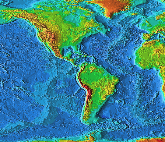
Alfred Wegner (1924) proposed that in the past there had been only one supercontinent, Pangaea. Hundreds of million years ago, Pangaea broke up and the pieces began to drift apart. [Look at a map of the Earth for the reason Wegner suggested this novel idea. Strong evidence for this hypothesis comes from fossils in South America and Africa which indicate that around 200 million years ago both regions had similar lifeforms and that tropical lifeforms existed in Antarctica and from paleomagnetism, the study of the Earth's magnetic field.]
Today, we have measured the motion; the continents are drifting apart at a rate of 2 - 4 cm per year.
The reason that this idea which seems so compelling was not initially accepted was that no one could imagine how things like continents could move around (or more precisely, what could push continents around). Today, we believe that have at least a zero-th order to first-order understanding of the mechanism involved in tectonic motions (however the details still elude us).
Recall that the interior of the Earth is hot and that it can be divided up into the crust, mantle, and core based upon chemical differences but that from a mechanical standpoint, it was better to consider the crust and the outer part of the mantle as one unit, the
The oceanic crust is thin (< 6 km) and is composed of basalts, similar to those found in lunar maria. The oceanic crust is denser than the continental crust.
The continental crust is thicker (~ 20 - 70 km) and is composed of granites. Granites (as are the basalts) are igneuous rocks, however, granites were formed under high pressure below the surface of the Earth. The continental crust is less dense than the oceanic crust.
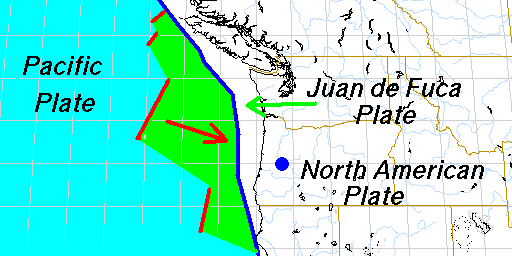
The lithospheric plates are thought to be moved around by convective motions. Because the Earth is hottest at its center and cools as one moves outward an outward flow of heat is set up. Through the solid portions of the Earth, the heat is carried by conduction, but in the liquid and in the liquid and plastic portions of the Earth, the heat is carried by convection. The large scale circulations (motions) in the asthenosphere moves the overlying lithospheric plates on the surface of the Earth leading to the continental drift observed today.
The lithospheric plates separate (new crustal material is produced) near rifts. There is a large rift in the mid-Atlantic stretching from Iceland to Antarctica. Overall, there are around 60,000 km of active rifts on the surface of the Earth. Most are in the oceans, but some are on land, e.g., the Great Rift Valley in Africa.
Because the Earth is not growing in size while crust is created continuously implies that crustal material is also destroyed continuously. To see and where and how this occurs consider the interactions when plates collide. There are three types of interactions which occur near plate boundaries:
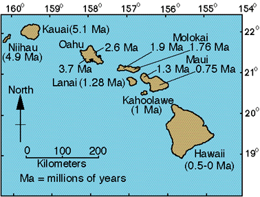
The Hawaiian Islands represent a different kind of volcanism. They do not occur near plate boundaries. They are formed near a hot-spot in the mantle of the Earth. Through these so-called plumes, magma rises to the surface. The magma oozes to the surface forming what are known as shield volcanoes (as opposed to cinder cone volcanoes). Shield volcanoes have gradual slopes and are produced by lava flows building up upon each other. The Hawaiian islands are the largest volcanoes on the Earth having bases with diameters of 100 km and heights of 9 km. The reason that there is an island chain is due to the fact that the Pacific plate is moving (at a rate of a few cm per year). In 1 or 2 million years that plate moves a distance equal to the average separation between the islands. Thus the island chain represents a time sequence with the Big Island being the youngest. This process is still continuing. There is another Hawaiian island forming, Lohi, about 20 km south of the Big Island. It is currently about a kilometer below the surface of the water. It is expected to make its appearance in 50,000 years or so.