|
References: Jeff Thomas, Oregon High , Keep Climbing Press (Portland, OR 1991)
| Mt. Hood is the highest peak in Oregon, and one of the solitary volcanoes that are common in the Pacific Northwest. Its vicinity to the city of Portland, OR and the multitude of ski lifts on its lower slopes make it an extremely popular climbing objective. It regularly makes the national news due to spectacular accidents, but in evaluating this one has to keep in mind the huge number of people who routinely climb it. As with most volcanoes, the guiding principle for climbing Hood on any route is: the more snow and ice there is on the mountain, the better; but of course one has to watch out for avalanche conditions. Also, in spring and early summer snow conditions can deteriorate rapidly by mid-day, which regularly gets climbers in trouble, and in winter thaw-freeze cycles can cover large parts of the mountain with water ice. |
|
|
|
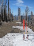
Topo Map South
|
||
| Routes :
South Side (moderate snow climb, steep ski descent)
References: Jeff Thomas, Oregon High , Keep Climbing Press (Portland, OR 1991) |
||
Date: January 28, 2017
Party: DB solo
Route: Cooper Spur to about 7,500'
Equipment: AT skis
Time: Trailhead - Tilly Jane: 1 hrs 40 mins
![]() Trailhead - ~7,500': 4 hr 30 mins
Trailhead - ~7,500': 4 hr 30 mins
![]() High Point - Trailhead: 1 hr 40 mins
High Point - Trailhead: 1 hr 40 mins
![]() Roundtrip from Trailhead: 6 hrs 30 mins
Roundtrip from Trailhead: 6 hrs 30 mins
Comments : Good skinning conditions below 7,400', sheer water ice above 7,400'
So I went down to my skies, had lunch, and enjoyed the views. The major peaks were all visible above a layer of fog in the valleys, and the very delicated sky colors made for a very pretty impression. On the other side Hood towered above me in the pale winter light. The skiing down the spin drift on ice was okay; the skiing down the gully to Tilly Jane was quite good, and sliding down the trail was fun. The snow pack was decent, but not exactly impressive; hopefully there will be some more snow before it gets too late.
On the way down I almost made the same mistake I had made in 2012; namely, go down the ridge on the south side of Polallie Creek. One must remember to exit the sloping plateau to the left, staying close to the Elliott Glacier moraine! In windswept conditions, when it's impossible to see where one came up, it's very tempting to go right, which is a huge mistake.
Date: December 27, 2012
Party: DB and PB
Route: Cooper Spur to Point 8,514
Equipment: AT skis
Time: Trailhead - Tilly Jane: 1 hrs 45 mins
![]() Trailhead - Point 8,514: 5 hr 30 mins
Trailhead - Point 8,514: 5 hr 30 mins
![]() Point 8,514 - Trailhead: 1 hr 15 mins
Point 8,514 - Trailhead: 1 hr 15 mins
![]() Roundtrip from Trailhead: 7 hrs
Roundtrip from Trailhead: 7 hrs
Comments : Reasonable skinning conditions
There was a good skin track, and we made it to Tilly Jane in well under two hours. Once we got above tree line some cloud formation set in, to the point where we expected to get whited out pretty soon. However, the clouds settled as a sea of clouds around the mountain, and we continued up Cooper Spur. On the final slope up to Point 8,514 the sun disappeared behind the ridge, the wind picked up, and it got seriously cold. Wearing everything we had brought, we got to the high point just at 3pm, our turnaround time. It was too cold to sit around, and we were short of time, so we started skiing very soon. Skiing the sastrugi high up was not as bad as we had feared, lower down on the moraine we found some good powder, below tree line the snow was a bit heavy, but overall it was very decent skiing for December in the Oregon Cascades. We reached the car just around sunset and headed back to Portland for beer and ribs at the Deschutes Brewery.
Date: April 7, 2012
Party: DB solo
Route: Cooper Spur to Point 8,514
Equipment: AT skis
Time: Trailhead - Tilly Jane: 1 hrs 45 mins
![]() Trailhead - Point 8,514: 5 hr 30 mins
Trailhead - Point 8,514: 5 hr 30 mins
![]() Point 8,514 - Trailhead: 4 hrs
Point 8,514 - Trailhead: 4 hrs
![]() Roundtrip from Trailhead: 9 hrs 30 mins
Roundtrip from Trailhead: 9 hrs 30 mins
Comments : Time down includes picking the wrong ridge below tree line.
After a bad night due to a stomach bug I got a very late start (which almost got me in trouble on the way down), and it was 10am by the time I started skinning from Cooper Spur Ski Area. I made good time to Tilly Jane, and continued on an existing skin track towards Cooper Spur. The snow was wet, and soon after Tilly Jane I developed problems with gloppy skins, which forced me to pause and apply wax twice (I think this was the first time ever this happened with my Ascension skins). It had been surprisingly warm in the forest, but as soon as I crossed tree line the wind picked up and it got cold. At the same time the snow consistency changed drastically, from sticky to a very thin layer of wind-blown sandy stuff over ice. I put an ultralight shell over my reflective-liner shirt and continued to the stone shelter, which was almost completely covered in snow, and to the big boulders, where I passed a party that had passed me when I had skin problems. The wind was howling at this point, and taking my gloves off led to numb fingers within seconds. I briefly considered turning around, but then put on my puffy jacket over my shell and continued. Point 8,514 is always surprisingly far, and the poor snow conditions and the fact that I had been sick during the night did not help. By the time I reached Point 8,514 in a full gale it was 3:30, but I figured with 4 hours to sunset I had plenty of time. The other party had turned around and was out of sight by now. I admired the view for a short time and then headed down to get out of the wind.
The skiing was okay at best, it was hard to find a good line between blank ice and windblown sandy stuff where my edges would catch. I took shelter behind one of the big boulders and tried to light the stove, but even the lee side of the biggest boulder did not provide enough wind protection, so I gave up and settled for more nuts and raisins. Continuing down I could not see any tracks, neither my own from going up nor the other party's from going down. I let snow conditions determine my line, realized at some point that I was too far to skier's right and corrected, but still did not find any tracks. When the terrain finally leveled off I realized I was quite a bit below Tilly Jane on the wrong ridge. I saw a burned ridge to the north, which I figured was the right one, but unfortunately I was separated from it by a very deep and extremely steep canyon. I figured - correctly, as it turned out - that continuing down the wrong ridge was not a good idea, as it would make me miss the access road to the ski area and force me to pick my way all the way down to the highway through dense forest. So I started skinning back up, but soon realized that this would take me too long, given that I had to break trail in deep snow and was pretty tired. So I took my skins off and skied down into the canyon to near its head, where I could cross the creek. I downward traversed for a little while on the other side, but then had to face the fact that I had to climb back up. It was much too steep for skinning, and while boot packing I postholed to my thighs with every step. It was only about 600 vertical feet, but it was extremely hard work. When the angle eased I put my skies back on and tried to traverse again, but soon cliffed out, gave up and postholed all the way to the crest. There I found tracks, and soon also the blue diamonds that mark Poiallie Trail. Lousy skiing on poor snow brought me back to the ski area with a few minutes to spare until sunset.
The upper part of the route in the high-wind conditions was impressive, but the skiing was not very good, and my route finding blunder did not help. I should have gone elsewhere; I later learned that Jack Ski Summit, for instance, had decent snow that day.
At low elevation it was surprisingly warm ... |
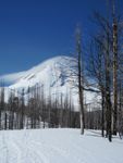
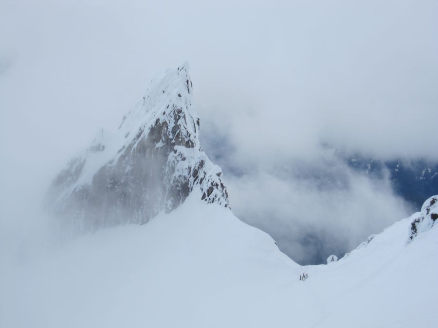
... but the lenticular clouds were harbingers of thing to come. |
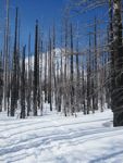
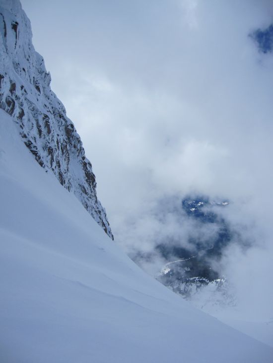
View from tree line. |
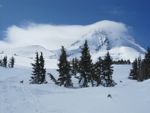
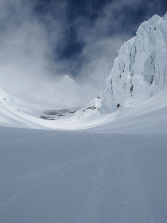
The furious wind is apparent from the cloud pattern. |
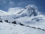
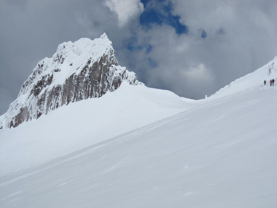
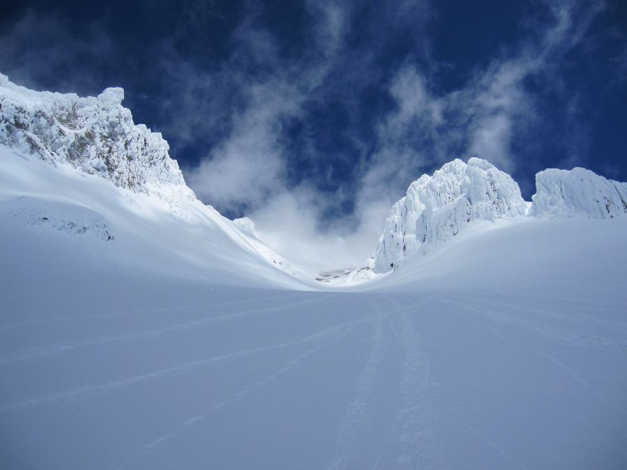
View up upper Cooper Spur from Point 8,514. |
View north from Point 8,514. |
Date: July 11, 2011
Party: DB solo
Route: S Side, Old Chute
Equipment: crampons, ice axe, AT skis
Time: Top of Palmer - Summit: 3 hrs 30 mins
![]() Summit - Timberline Lodge: 2 hr 30 mins
Summit - Timberline Lodge: 2 hr 30 mins
![]() Roundtrip from Top of Palmer: 7 hrs
Roundtrip from Top of Palmer: 7 hrs
Comments : Very icy.
After a lengthy lunch at the Hogsback I skied down on surprisingly good, if pretty corrugated, snow. The snow did not become sticky until half way down the Palmer, at which point I escaped onto the groomed slopes, which were still in good shape.
These were very unusual conditions for mid-July, brought about by a combination of a severe La Nina in general, which led to a lot of snow for the time of year, and a cold front that had moved through two days earlier in particular, which I presume was responsible for the ice. Not a bad ski trip for July 10, even though I did not manage to ski from the summit.
Date: June 4, 2011
Party: DB solo
Route: Cooper Spur to Point 8,514
Equipment: AT skis
Time: Cooper Spur Trailhead - Point 8,514: 5 hrs 5 mins
![]() Point 8,514 - Trailhead: 1 hr 50 mins
Point 8,514 - Trailhead: 1 hr 50 mins
![]() Roundtrip from Trailhead: 7 hrs 50 mins
Roundtrip from Trailhead: 7 hrs 50 mins
Comments : The Snowline was at 5,300'. Mostly good skinning conditions.
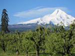
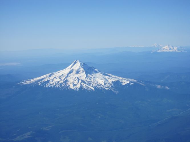
Mt. Hood from the orchards along Highway 35. |
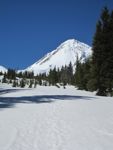
Mt. Hood from near tree line. |
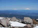
Mt. Rainier and Mt. Adams from the big boulders. |
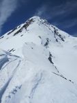
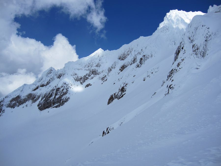
Upper Cooper Spur from Point 8,514. |
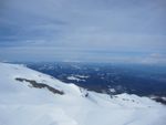
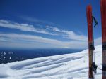
View South from Point 8,514. |
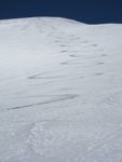
My tracks skiing off of Point 8,514. |
||||||
Running out of snow. |
Date: July 7, 2010
Party: DB solo
Route: Sunshine to Snow Dome
Equipment: AT skis
Time: Cloud Cap Saddle - Snow Dome: 4 hrs
![]() Snow Dome - Cloud Cap Saddle: 1 hr 30 mins
Snow Dome - Cloud Cap Saddle: 1 hr 30 mins
Comments : * Good conditions, I carried crampons and ice axe but never took them off my
pack, skinning all the way up.
![]()
![]() * I forgot my camera! Amar Andalkar took some
nice pictures on his 2005 (pre-flood) trip.
* I forgot my camera! Amar Andalkar took some
nice pictures on his 2005 (pre-flood) trip.
The day before I had gotten up at 5am only to see that the Magic Mile weather station at 7,000' was recording 50mph winds, so I went back to bed. Today the forecast was for even stronger winds, but since this was my last chance I went anyway and lucked out; the weather service was in the business of predicting yesterday's conditions.
The drive up to Cloud Cap Saddle takes a long time even from Portland, and it was 8:30 by the time I got going from the trailhead. It turns out that the Eliot Creek drainage has never been the same after a flood in 2007 (or was it 2006?); the westbound part of Timberline trail is closed, and crossing the gully is a pain at best. So I did what everybody seems to be doing these days, namely, start on the Cooper Spur Trail and approach the Snow Dome via the lower portion of the Sunshine Route proper. That's fine, but it deprives one of the possibility of skiing the Langille Glacier, where the snow reaches down much lower than on Eliot Glacier.
The descent from the moraine to Eliot Glacier is marked by the world's largest cairn, but since I was hiking a snow field off the moraine rather than the trail on top I managed to miss it. So I slid down the moraine a bit higher up and started skinning. While I was sliding down the moraine a lone skier came down the glacier, and quite a bit ahead of me was a party of two with a dog, otherwise there was nobody around. I made good progress and skinned up to the top of the Snow Dome. The party ahead of me opted to ski from the base of the Snow Dome, so I had the thing to myself. The views are phenomenal.
After cooking lunch I started down. 1,500 vertical feet of perfect corn were followed by 1,500' of decent snow, then I was back at the moraine trail, sadly. From the lower portion of the glacier I saw that while I had been slogging up some badass party had skied off the summit in between Cooper Spur and the North Face, an incredibly exposed and committing line. I did not see them, but the tracks were unmistakable. (On June 27, 2010, Dan Helmstadter and John Plotz did what seems to have been a first descent of this line, or a very similar one. There's no way their tracks could have remained visible from Eliot glacier ten days later, so I suppose someone repeated it.) I took my skies off, and 45 minutes later I was back at my car.
The Snow Dome is a very enjoyable trip and provides very moderate skiing in a superb scenery. The rest of the Sunshine Route looks very nice, too; I need to do that some time!
Date: May 8, 2010
Party: DB solo
Route: South Side to Illumination Saddle
Equipment: Crampons, AT skis
Time: Top of Palmer Lift - Saddle: 1 hr 20 mins
![]() Top of Palmer Lift - High Point: 2 hrs
Top of Palmer Lift - High Point: 2 hrs
Comments: Marginal snow conditions.
The forecast was ambiguous, and I did not care for a third trip in a row to Hood in bad conditions, so I did not pack anything on Friday. I woke up at 5:30, and it was solidly overcast, so I went back to sleep. Next time I woke up it was 7:30 and sunny, so I jumped out of bed and got going. Given the late hour my only chance was to ride the lift and climb from there, and I figured Illumination Saddle was as good an objective as any.
I skied the Palmer once for warmup, before starting to climb at 11:20. I opted for bootpacking, but the snow conditions were not ideal. Sometimes fine, sometimes too soft, and sometimes a thin layer of snow over water ice. Some people were skinning, but that was probably not ideal either. Conditions got worse the higher I went, but some skiers were coming down from Crater Rock and they seemed to be doing okay. By the time I reached Illumination Saddle a squall was forming just beyond the saddle, which made for some impressive views. I admired the Reid Glacier and Yokum Ridge for a while, then backtracked my tracks for a few hundred feet and started climbing towards Crater Rock. The snow was getting very sticky at that point, and the going was slow. There were tracks from falling ice all over the slope, I came by some impressively large chunks of ice that had come down from Crater Rock, and the ice was starting to fall from the south-facing wall to my left, so I had no desire to linger too long or get too close to Crater Rock. I climbed out of the ice tracks to a little ridge at about 9,750', declared this my high point, and had lunch.
While I was eating the squall I had observed earlier briefly whited me out, but then moved on and the sun came back out. The skiing was okay; not great, but much better than the last two times I had been up there. The Palmer lift was closing just as I got down, but the Magic Mile was still running and I got one more run in before heading back. An easy but nice trip with some impressive views.
Approaching Illumination Saddle. |
Reid Glacier and Yokum Ridge from the saddle. |
View down past Illumination Rock from the saddle. |
View back on Illumination Rock. |
View up to Hot Rocks and Crater Rock. |
Another view of Hot Rocks and Crater Rock. |
Date: April 10, 2010
Party: DB solo
Route: South Side
Equipment: AT skis
Time: Timberline - Top of Palmer Lift: 2 hrs 10 mins
![]() Roundtrip from Timberline Lodge: 3 hrs
Roundtrip from Timberline Lodge: 3 hrs
Comments: High winds.
I seem to have no luck with the weather this winter. The forecast was for a one-day break in the lousy spring pattern, and I decided to try the new powder on Hood. It was windy on the freeway, and from Gresham I could already see the wind-driven plume of snow on Hood. At Timberline it was blowing impressively, and the lifts were all closed. I made good progress skinning, but occasionally the gusts threw me off balance. My estimate was sustained winds of 25mph with gusts to 40, but I later saw that the Weather Service had measured gusts to 48mph at 7,000' while I was going up. At the top of the Palmer lift things were pretty furious and I decided to call it quits. I found a little bit of shelter behind a mound of snow, and lying there was reasonably comfortable, but when I took a glove off to get some nuts out of my pack my hand got cold very quickly. Well, 20 degrees at 50mph makes for a windchill temperature of -3. No wonder my hand got cold.
Skiing down was okay, but not an award winning experience: Powder on wind slab on frozen crust. It usually was okay for a few turns, but then an edge would catch, so I went slowly. By the time I got back to Timberline the wind had calmed down a little bit and some of the lower lifts were running, so I got a few more runs in before driving back to Portland.
Date: January 24, 2010
Party: DB solo
Route: South Side
Equipment: AT skis
Time: Timberline - Top of Palmer Lift: 1 hr 50 mins
![]() Top of Palmer - High Point: 30 mins
Top of Palmer - High Point: 30 mins
![]() Roundtrip from Timberline Lodge: 4 hrs
Roundtrip from Timberline Lodge: 4 hrs
Comments: Very good snow conditions for skinning, very poor visibility for skiing.
I was dropping off my wife at PDX at 5:30am, so I decided to keep going on to Hood, the lousy forecast (which called for a storm to hit by mid-morning) be damned. At Timberline it was cold and blustery, and I started out at 7:10 wearing a full shell. The sunrise behind the clouds to the east was impressive, but the weather was clearly deteriorating fast. Snow conditions were very good, though, and I skinned to the top of the Palmer in an impressive 1 hr 50 mins. At that point the visibility was already very poor, and I figured I would not go much higher. After a brief rest stop I continued skinning anyway, until I called it quits at around 8,800'. I was not really in a whiteout - I could still occasionally see the lift - but there was virtually no contrast, and as a result it was difficult to see what was up and what was down, and it was impossible to discern any terrain features, large or small. This made skiing extremely difficult. In addition, it was even hard to tell whether I was moving or not. Several times I fell while being at a full stop. It took me a while to figure out the reason: The spin drift gave my brain the illusion that I was still moving, and there were no other reference points that could have served as a check. It was an extremely weird sensation that I had never experienced before. Going down took me an accordingly long time, led to some nausea because of the lack of reference points, and generally was not exactly fun. Another party that had skinned up to the Palmer mid-station gave up, left their skins on, and snowplowed down a sno cat track. Maybe that was a better idea than my insistence on making blind turns. When I got back to Timberline shortly after 11 the storm was fully developed, it was snowing hard, and I just barely managed to get out of the backcountry parking lot without having to put on chains.
Not exactly a ski trip to write home about, but it was still fun to get out, and going up was good exercise.
Date: May 30, 2009
Party: DB solo
Route: South Side
Equipment: Crampons, ice axe, AT skis
Time: Top of Palmer Lift - Summit: 3 hr 15 mins
![]() Summit - Timberline: 1 hr 15 mins
Summit - Timberline: 1 hr 15 mins
![]() Roundtrip from Timberline Lodge: 5 hrs 30 mins
Roundtrip from Timberline Lodge: 5 hrs 30 mins
Comments: Warm weather had been around for a while.
I'm a lazy bum, so I decided to take my chances with the snow conditions, wait until the Palmer lift opened, and climb from there. I got going from the top of the Palmer at 9am sharp, just as planned, and climbed on reasonable snow in 2 hours to the hogsback. Conditions looked okay, so I decided to keep going. The hogsback has shifted and no longer points to the Pearly Gates, so the standard route now is the Old Chute (again). There was some minor rockfall from the cliffs on either side of the chute, so I and a party of two nearby made sure we stayed in the middle of it. When we were close to the top, we heard a lot of noise below, and it turned out that a much bigger rock had come loose, took a somewhat unexpected path, and came close to a party low in the chute. Several parties wisely turned around after that, and I realized that my lift strategy had given me just enough time to safely get up there. Just ahead was a party of two with skis that turned out to be Asit Rathod and partner.
We enjoyed the summit views for a while, and then prepared for the descent. On Asit's advice we did not go down the Old Chute, which was quite choppy from all the climbing, but continued along the summit ridge to the next chute. It looked pretty intimidating. The snowboarder in the other party of two (his partner had downclimbed the Old Chute) went first and had a very impressive run. Asit went next, equally impressive. His partner had his binding release just at the point where it goes from steep to really steep, but narrowly caught himself and got down with no further problems. So now it was my turn, apparently. The short steep part I handled with no problems, but when entering the really steep part I got too far to the right and found a slightly icy surface. I was worried that at the end of a jump turn a ski would catch, so I sideslipped about 500 vertical feet until the slope became a bit gentler and the snow softer, at which point I resumed making turns and skied over to the hogsback.
After lunch below Crater Rock I skied some good snow, then okay snow, then lousy snow down to the lifts, and then more lousy, but groomed, snow down to Timberline. Very nice trip, and I finally skied Hood from the summit!
PS: A word on timing and conditions on Hood: Conventional wisdom is that one should start from Timberline around midnight, summit around 6am, and then get the hell down before the snow turns to mush. In late spring and early summer, anyway. Well, that's sometimes true, but as an absolute statement it's bullshit. Today I had figured that a warm spell over the last two weeks would have consolidated the snow, and reasonable conditions could be found around noon, even though it was quite warm. That turned out to be true. In fact, if I had summited at 6am I would probably have had to wait about 6 hours for the crater wall to come into reasonable skiing conditions. And an early start is no guarantee for safe climbing conditions either. There were several accidents over the last two weeks that could be attributed to mushy snow and falling ice very early in the morning (that was at the start of the warm spell). On the other hand, it's also true that the rockfall I just barely stayed ahead of was a direct consequence of the late hour. The bottom line is that one has to carefully watch the conditions no matter when one chooses to climb, and turn around if things don't look right, or are anticipated to no longer look right by the time it's time to descend.
Date: January 18, 2009
Party: DB, Rudy Kohnle, and Dave Ruuhela
Route: South Side
Equipment: Crampons, AT skis
Time: Timberline Lodge - Top of Palmer Lift: 3 hr 10 mins
![]() Top of Palmer - 9,200': 1 hr 20 mins
Top of Palmer - 9,200': 1 hr 20 mins
![]() Roundtrip from Timberline Lodge: 7 hrs
Roundtrip from Timberline Lodge: 7 hrs
Comments: High winds, surface covered with water ice.
We started from Portland before 6am, but getting ready took a while and we did not get going from Timberline until 8am. It was a beautiful day, with fog all over Eastern Oregon and a strong wind blowing from the east. Rudy and Dave skinned, whereas I opted for bootpacking, a decision I sometimes doubted when the wind caught my skis and almost blew me over. At 7,000' we put in a brief rest stop, and I realized why my boots felt unusually uncomfortable: I had put my right liner in the left boot, and vice versa. After fixing this we continued, and made steady, if slow, progress to the top of the Palmer lift, where we arrived shortly after 11am.
The surface above that elevation looked very icy and corrugated, clearly not suitable for skiing, and so we cached our skis, Rudy and Dave donned crampons, and we all continued on foot. The conditions were extremely unusual: The entire mountain was covered in a layer of water ice, apparently a few feet thick in places, and on the surface were oddly shaped ice formations that ranged from a few inches to about 2 feet in size. The color of the ice was an amazing blue, and in between there was only a tiny bit of wind-blown snow, if any. All of this must have been the result of a warm storm about ten days earlier, when the snow level briefly went up to 12,000' before it dropped back down to 1,000' and all the rain and melted snow froze solid. A week earlier I had observed the results in the form of trees encased in water ice on a trip to Jack Ski Summit; here the entire mountain seems to be encased in water ice. We picked our way through the ice formations until Dave developed some severe leg cramps around 8,900'. We did not have much time anyway, as we had to be back in town early, so Dave and Rudy called it quits there and enjoyed the views for a while, while I continued a bit. I veered left towards Illumination Saddle, where the blue color of the ice intensified even more. I did not have enough time to go quite into the saddle, so I did an ascending traverse until I could look around Crater Rock on its northwest side. At 9,200' and maybe a quarter linear mile from the saddle I turned, climbed a short distance towards Crater Rock, and then returned to the top of the Palmer, catching up with Rudy and Dave just as they got there.
The skiing down was nice, if a bit icy, and we appreciated the groomed slopes, given the corrugated surface even at low elevations. The low clouds over Eastern Oregon had not gone away, and I suspected that it was just as well that earlier plans to go climbing at Smith had fallen through. Sure enough, as I found out later, the temperature at Smith had been 24 degrees with freezing fog all day. Hood had definitely been a better option. Very impressive trip, even though we did not get very high.
Date: November 30, 2008
Party: DB solo
Route: South Side
Equipment: Crampons, AT skis
Time: Top of Palmer Lift - Base of Crater Rock: 1 hr 20 mins
Comments: I climbed from the top of the Palmer ski lift.
After getting rained out the day before with Rudy I tried again solo, but got a late start and hence opted for riding the Palmer. There was very little snow; a warm spell throughout most of November had melted most of what had fallen before. After two runs on the Palmer snow field I finally started out from the top of the lift around 11:30. Good snow gave way to rime ice, and when I approached Crater Rock I noticed small ice avalanches being released every few minutes. Across the gully, huge ice avalanches came off the Steel Cliff at the same frequency. Clearly, this was not a good day for being high on the mountain, the rime ice could not take the warm temperatures. So I called it quits at the base of Crater Rock, a bit above 10,000'. The views were very nice, as a cloud cover had moved in and produced impressive colors. Skiing down was nice despite the rime ice, and I had enough time left to ski the Palmer a few more times.
Date: May 4, 2008
Party: DB and Rudy Kohnle
Route: South Side
Equipment: Crampons, AT skis
Time: Top of Palmer Lift - Hogsback Saddle: 4 hrs
![]() Roundtrip from Timberline Lodge: 6 hrs
Roundtrip from Timberline Lodge: 6 hrs
Comments: We rode the Palmer ski lift, and climbed from there.
I was itching to get out, and Rudy and I had wanted to go skiing together for a long time, and finally the weather and our schedules cooperated. Rudy wanted to do St. Helens, but the State of Washington had discontinued plowing (they did not discontinue charging us for sno park permits, but that's a different story), so St. Helens in a day was not an option. That left Hood as the obvious objective, and since we had limited time we decided to make it an easy day by taking advantage of the Palmer lift. This pretty much ruled out summiting, but we figured that skiing from the Hogsback would make for a nice trip.
We got to Timberline just as the lifts opened, took a wrong turn, and went downhill quite a bit instead of taking the Miracle Mile lift up. After riding back up and then taking the Miracle Mile lift, we found that the Palmer lift was not open yet, so it was just as well that we done a warmup run first. We did not have to wait too long, but by the time we got going from the top of the Palmer it was 10:15, pretty late for getting going on Hood in May! I opted for carrying my skis, while Rudy experimented with skinning, which did not work all that well, so he switched soon. We took it easy, but made steady progress on firm, well consolidated snow. It had been cold the night before, and the snow was still decent when we reached the Devil's Kitchen at 1:45. Rudy declared this his high point, whereas I continued about 300 vertical feet to the saddle in the Hogsback. At that point the solar radiation had led to quite some cloud formation, and the upper part of the mountain kept drifting in and out of the clouds, which was very impressive.
A steep traverse towards Crater Rock, followed by a few jump turns, got me back down to Rudy's position, and then we skied down together. The snow was still surprisingly good high up. Once we hit the groomed slopes it first got soft, then sticky, but it was still decent and fun skiing with great views.
A very nice and surprisingly impressive trip. I still have to ski Hood from the summit, though!
For earlier ascents, click here .