|
Description of the Galapagos Islands Isla Santa Cruz 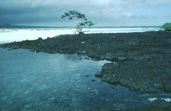 | | An old lava flow that helped form Tortuga Bay. Picture source: http://www.geo.cornell.edu/geology/GalapagosWWW/SantaCruz.html |
Santa Cruz, also called Indefatigable Island, is located in the center of the Galapagos archipelago. It also the center of human activity in the Galapagos, since the National Park Headquarters, the Darwin Research Station, and the largest settlement in the Galapagos, Puerto Ayora, are all located on Academy Bay on the south side of the island. The main airport, originally an air base built by the US Navy during WW II, is located on Baltra, a small, low island separated from the northwest corner of Santa Cruz by the narrow Itabaca Channel. Santa Cruz is the only island having a road that crosses its interior (running from Puerto Ayora in the south to the Itabaca Channel crossing in the north), thus providing tourists a rare opportunity to see the interior and higher elevations of a Galapagos island. Santa Cruz is a shield volcano, slightly elongate in an east-west direction. A line of young cinder cones marks the crest of the island, running east southeast to west-northwest and reaching an elevation of 950 m at Cerro Crocker. This crest divides the dry leeward northern half of the island from the wetter, more heavily vegetated windward southern part.
Two distinct periods of volcanic activity are apparent on Santa Cruz. The earlier period produced the "Platform" lava series, which may be seen in the northeast and on the neighboring small islands of Baltra, Seymour, and Las Plazas, small islets just off the northeast coast. They are flat-lying or gently dipping lavas interbedded with shallow marine sediments and limestones ranging in age from about 1 million years to as old as 2.3 million years. Some of these have a pillow morphology, a characteristic of submarine eruption. These lavas thus record a period of volcanic growth, subsidence, and subsequent uplift. At least some of these lavas were erupted from vents in the northwest; the vents of others may be buried beneath the central highlands.
The period that produced the younger "Shield Series"lavas that consistute the bulk of the volcanic edifice began perhaps 700,000 years or so ago. With time, volcanism became focused along a ESE-WNW fissure system that now defines the crest of the island. Judging from the lack of soil between flows exposed in pit craters at the summit, development of this ediface must have been quite rapid. The youngest lavas are located in the northwestern corner of the island. These pahoehoe flows are completely unvegetated and are probably no more than a few thousand years old. Thus Santa Cruz should be considered an active, though dormant, volcano. The chemistry of the shield series lavas differs subtly from that of the platform series, perhaps due to the change in the volcano's location relative to the plume over time as it drifts slowly eastward on the Nasca Plate.
Fairly recently, in a geologic sense at least, Santa Cruz has been cut by east-west faults that have produced a number of graben structures. A graben is a down-dropped block bound by faults. This kind of structure is characteristic of extentional deformation of the crust. The Itabaca Channel, which separates Baltra from Santa Cruz, is one clear example of a graben. Academy Bay, on the south coast, is another fine example, as is Tortuga Bay. A wonderful white sand beach is located at Tortuga Bay, about a 40 minute walk from Puerto Ayora. The path crosses the dramatic fault that bounds the Academy Bay graben on the south side. Similar east-west faults may be found on the islands of Santa Fe and Espanola.
|