Northern Great Basin Prehistory Project
Archaeological Field School
2018 Summer Session
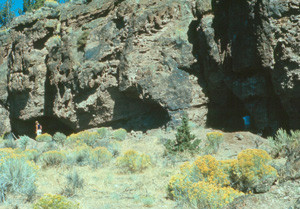
Introduction to Connley Caves Research

Stephen Bedwell and a crew of University of Oregon graduate students excavated at the Connley Caves (35LK50) in the Fort Rock Basin during the summer of 1967. This work was conducted under the general direction of Professor Luther S. Cressman, and formed the basis for Bedwell's University of Oregon doctoral dissertation (Bedwell 1970). While Bedwell drew on the data collected from all of these sites, none have remained as pivotal to our understanding of human response to changing paleoclimate and ecology in the Northern Great Basin as the archaeology at the Connley Caves.
For the last three decades researchers have cited Bedwell's doctoral dissertation (1970) and post-mortem publication (1973), even though they suspected there were serious problems with the data (cf. Grayson 1979, 1993 for examples). The main reasons for citing his work were the large numbers of radiocarbon dates and diagnostic materials recovered by Bedwell from the four meters of stratified cultural deposits at this site. Few other sites in the Northern Great Basin, other than the Paisley Caves, have produced such an impressive and widely-cited archaeological record. However, Bedwell's interpretations of the Connley Caves data has sparked vigorous debate about the importance of wetlands resources to Early Holocene occupants of the Great Basin. Most importantly, the validity of his radiocarbon dates, paleoecological-climatic reconstructions, and species identifications have been questioned and often proven spurious (cf. Grayson 1979). Consequently, it was imperative to reinvestigate the Connley Caves.
Our research goals for the reinvestigation of the Connley Caves are to provide more carefully controlled excavations and more reliable analysis of the archaeological and natural samples available at the site. In 2000 and 2001 we began reevaluation of the archaeological and paleo-ecological data from the site and used it to address refined questions important to the region, particularly those of the Pleistocene/Early Holocene transitional period. We will continue this research by applying stronger integrative theory and investigative techniques developed since the time of Bedwell's research.
UO Field School Excavations at the Connley Caves: 2000 - 2001
Bedwell's research, in both the field excavations and laboratory analysis, suffered from a lack of close attention to detail. We have documented his disdain for personal involvement in the excavations, he preferred to leave the excavations and documentation to his crew while he mapped the sites and looked for new sites. For their part, the crew also preferred to have him out of the picture (Bussey and Rohrbaugh, personal communications). We believe that this lack of personal 'hands-on' field experience at the site meant that Bedwell never fully appreciated the complexity of site formation processes operating there. In the laboratory, Bedwell also chose to uncritically accept species identifications, radiocarbon dates, and artifact associations (cf. Grayson 1979 for a more complete discussion). In any new investigation then we must begin by determining what we should accept and what we should reject in Bedwell's data and interpretations. This requires an accurate understanding of the natural and cultural site formation processes affecting the deposits of the caves and is absolutely the single most vital issue of an adequate reassessment of the site. Consequently, we approach the re-excavation and analysis of the Connley Caves with extreme caution, careful planning and closely supervising all phases of investigations.
2000 Field Investigations. The 2000 investigations at the site began with the excavation of backhoe stratigraphy control trenches in front of Caves 5 and 6 in areas Bedwell had previously placed backhoe 'test holes'. In each case, an effort was made to cut through part of his trenches nearest the caves to minimize damage to the remaining deposits while exposing undisturbed colluvium.
The backhoe trench in front of Cave 5 was off-set to the east of the cave center where Bedwell's notes indicated his 'test hole' had been located. The new trench was five meters long. At the northern headwall, nearest the cave, it cut through a large pocket of nearly pure Mazama tephra between 150 and 250 cm. The steep angle-of-repose of the tephra in this pocket clearly indicated this was back-fill in a steep sided hole. The backhoe brought up a crushed and heavily rusted WD-40 can in the tephra deposits, dating the disturbed deposits to the modern era. Below the disturbed tephra, near the 'head' of the new backhoe trench, was an undisturbed paleosol rich with cultural debris including Foliate point bases and lithic debitage. The southern end of the previous disturbance was obvious in the new side wall. Beyond it were culturally enriched post-Mazama sediments that appeared to be undisturbed. A second five meter long backhoe trench was then excavated roughly three meters south of the first. It cut through dense Mazama tephra at about the same depth as the northern trench, but the paleosol below contained little cultural debris.
The backhoe trench in front of Cave 6 was excavated to the west of a shallow ditch running straight down the slope from the center of the cave mouth. This ditch is probably one of Bedwell's backhoe test trenches. The new backhoe trench was roughly seven meters long and 200 cm deep. Excavation was terminated when dense Mazama tephra was encountered. The stratigraphy exposed in this trench contained thick lenses of sorted gravels suggesting that water running out of a small ravine above the cave mouth had a strong affect on the formation of deposits in front of the cave. This process was closely observed during the summer of 2000, and again in 2001, as heavy local precipitation caused run-off to flow out of the ravine above the cave. The resulting waterfall and stream flowed into the cave interior, eroding the walls of the backhoe trench and test units. Though these events were brief, they clearly demonstrated the potential for flooding, erosion, sedimentary settling, and water damage to perishable industries within the cave interiors.
The majority of manual excavations at the Connley Caves were conducted in arbitrary five centimeter levels, and followed natural stratigraphy as much as possible. Excavated soil was passed through eighth-inch wire mesh and all cultural materials were recovered. Column samples of sediments 10x10x10 cm (1-2 liters) were taken from unit walls which appeared representative of the deposits in each cave. Additional soil samples were taken as new strata and cultural features were encountered. Ecofacts, including rounded beach gravels, botanical samples, and modern faunal remains from the surface of Cave 5, were collected for later study.
Manual excavations in front of Cave 5 began with three conjoined 1x2 meter excavation units forming a trench six meters long. The head of this trench was located one meter east of the backhoe trench and roughly two meters south of the cliff face. A 1x5 meter bulk was left between the bachoe and manually excavated trenches to provide stratigraphic control and to protect field school students from possible wall collapse in the area of Bedwell's 'test hole' at the north end of the backhoe trench. The thick, loose Mazama ash in this hole provided poor support for the heavy rock-laden deposits overlying them and the danger of wall collapse increased as the wind eroded the loose tephra from the sides of this trench. A barbed wire fence was erected around the backhoe trench and the walls of the manually excavated trench were shored up.
The manually excavated trench cut through six natural and cultural strata, reached a maximum depth of 310 cm, and removed 14.85 m³ of deposits. Small and large corner notched points were recovered to a depth of about one meter in these excavations. Foliate points were recovered below the Mazama tephra at about two meters. Very few tools and no projectile points were recovered from the circa one meter of colluvium and Mazama tephra deposits above the paleosol.
Investigations in Cave 6 during the summer of 2000 involved the manual excavation of three 2x2 meter units, a 1x2 m and a 1x1 meter unit. These excavations covered an area of 15 m², removed 16.9 m³ of deposits, and reached a maximum depth of 235 cm. Extreme disturbance of deposits to >120 cm was indicated in units 4 and 5 at the east side of the cave mouth. In Unit 6, located at the dripline on the west side of the cave, evidence of previous disturbances included laminations of water sorted sands and gravels in Quad B in the extreme northeast quarter of the 2x2 meter unit to a depth of about 75 to 90 cm. These modern deposits suggest that Unit 6 overlapped the eroded and collapsed west end of the 1x4 meter trench excavated by Charles Rohrbaugh and Stanley Bussey in 1967.
Cultural material was extremely dense in the upper 20 cm of deposit in Unit 6 where a thick lens of sorted gravel, charcoal, burned bone, and lithic debitage appeared to be the "dump pile" of intensive screening. Cultural material dropped off sharply below 30 cm, rose again at about 60 cm, and then dropped off sharply between 95 and 175 cm in Quad D, the least disturbed quad of the unit. Plastic and metal were recovered in Level 20 (95 to 100 cm) of Quad A and beer bottle glass was encountered in Level 33 (160 to 165 cm) in quads B and C. Thus, the strata I through IV deposits extending to Level 36 (180 cm) in Unit 6 remain suspect of mixing due to post-occupational disturbances and rodent activity. The most significant deposits sampled by this unit are the Stratum VI deposits below a depth of 190 cm.
2001 Field Investigations. The bottoms of excavation units in both caves were lined with plastic at the end of the 2000 field season and then backfilled by a backhoe. The 2001 field season began with the manual removal of backfill from units 1, 2, and 3 and the 2000 backhoe trench in front of Cave 5. Excavation of the one meter wide bulk between the manual and backhoe trenches in Cave 5 involved one 1x1 m (#9) and two 1x2 meter (#s 10 and 11) units. This resulted in the excavation of a roughly three meter by five meter block, the western third of which was an access ramp maintained through the south end of the reopened 2000 backhoe trench.
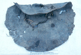
A 2x2 m excavation unit (#15) was attached to the north end of this block to remove extremely loose deposits between the cliff face and the northern end of the 2000 excavations. These deposits had continuously sloughed off throughout the 2000 field season, forming a large cavity behind the plywood shoring of the north and east walls of Quad A in Unit 1. The inclusion of woodrat feces, botanical, and faunal remains in the debris falling from behind the shoring suggested that this loose deposit was badly disturbed, possibly an old pothunters' hole or other historic intrusion. Shoring up this cavity for the 2001 field season required the squaring up of the walls so that the plywood would lay flat against the loose sediments, holding them in place. However, sagebrush cordage was encountered in these loose deposits during the process of shovel shaving the re-exposed walls. Consequently, Unit 15 was set up to provide provenience control for the removal of these troublesome deposits.
Excavation of Unit 15 proceeded in 10 cm levels through the extremely dusty and acrid smelling sediments of what appears to have been a large rat midden and garbage dump containing thick bundles of grass, juniper bark, sagebrush, bulrush stalks, basket fragments, bulrush matting and bag fragments, cordage, twine, and human feces. Associated Elko and Rose Spring type projectile points suggest that these materials date from the Late to possibly Middle Holocene period, i.e. historic to ca. 5000 BP? Excavations were terminated near the bottom of the Mazama tephra at 160 cm in this unit. All perishable materials were recovered in the loose, dry, coarse grained deposits above 140 cm. Below 140 cm were mixed tephra and silty-sandy sediments too moist to preserve perishable artifacts. Excavations were terminated in Unit 15 when the east wall of the unit was collapsed by after hours visitors to the site.
The 2001 controlled excavations in front of Cave 5 covered an area of 9.5 m². In addition, Unit 3, Quad A was reopened and controlled excavations continued to a maximum depth of 390 cm. Probing continued along the east wall of the unit through culturally sterile beach deposits to bedrock at a depth of about 440 cm. A total of 21.5 m³ of deposits were removed during the 2001 field season. The combined total area and volume of controlled excavations conducted in front of Cave 5 during the 2000 and 2001 field seasons was 15.5 m² and 36.35 m³, respectively.
At the west side of Cave 6, Units 6 and 7, initially opened during the 2000 field season, were shoveled out at the beginning of the 2001 field season. Unit 7, originally excavated as a 1x1 m unit adjoining Quad A of Unit 6, was expanded one meter south to form a 1x2 m unit conjoined with Unit 6 to form a 2x3 m block excavation. Unit 7, Quad B had been terminated at 95 cm during the 2000 field season. The 2001 excavations were continued in this quad to a final depth of 160 cm, while Quad D was terminated at a depth of 115 cm where a large boulder was encountered. Unit 6 2000 excavations were terminated at 90 cm in Quad A, 120 cm in Quad B, 155 cm in Quad C, and 235 in Quad D. All four quads of Unit 6 were excavated to 270 cm during the 2001 field season. The 2001 excavations of units 6 and 7 removed a total of 6.6 m³ of sediments. The combined 2000 and 2001 excavations in Cave 6 covered a total area of 16 m² and removed 23.5 m³ of deposits.
Site Stratigraphy and Chronological Controls.
UO investigations conducted at the Connley Caves identified seven primary strata in Caves 5 and 6. The upper strata (I-IV) are primarily colluvium composed of angular pinkish-brown volcanic tuffs and dark gray andesites. These materials range in size from pinkish sand granules to boulders eroded or broken out of the cliff face. Large quantities of these materials have also been transported into the site from the slopes above the caves by local run-off. They are liberally mixed in the site with reworked Mazama tephra. Sands and silts have also been blown up the slopes of the Connley Hills from Paulina Marsh by prevalent southwestern winds. Below Stratum IV is a massive quantity of Mazama tephra (Stratum V). Cultural remains encountered below Mazama tephra occur in a sandy-silt colluvium believed to be a paleosol (Stratum VI). Finally, Pleistocene beach deposits (Stratum VII) form the basal deposit overlying bedrock. The following descriptions of these strata are derived from field observations and do not reflect the measure of intense study generally afforded such important deposits by contemporary soil scientists. They are included here to more fully familiarize the reader with the deposits
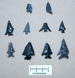
Stratum I. Stratum I, the upper-most 25 to 35 cm of deposits, was a mix of disturbed older deposits incorporating rounded lakeshore gravels dug from the bottom of the caves and newly deposited colluvium. It ranged in color from light grayish-tan to medium brown and occasionally included rich pockets of bone, charcoal, lithic debitage, broken stone tools, glass, wire, and tin. In Cave 5, the base of this stratum was formed by a dark brown, highly organic lens, one to four centimeters thick. Very small charcoal flecks and oxidized gravels mixed with cultural materials suggest that this lens may be surface deposit from the interior of the cave. Rose Spring projectile points were recovered throughout Stratum I deposits, along with historic debris. Disturbances in Cave 6 made the adequate separation of Stratum I deposits from other Late and Middle Holocene deposits extremely difficult if not impossible.
Stratum II. Stratum II, generally encountered between 30 and 100 centimeters, is a light tan to buff or slightly pinkish-brown colluvium with very angular gravels composing >50% of the deposits. The Stratum I/II boundary is very indistinct, and Stratum II is not consistently present at any particular depth. However, Stratum II is generally discernible as a lighter colored, coarse textured gravelly deposit separating the base of Stratum I from the top of Stratum III. Cultural debris is much reduced in quantity in Stratum II though some tools, charcoal, bone, and lithic debris continued to be distributed throughout. Stratum II may represent patches of fairly undisturbed colluvium, much of it resulting from periods of relatively infrequent human occupation.
Stratum III. Stratum III, generally varying in depth from 50 to 130 cm and clearly following the slope of the cave apron in Cave 5, is a light grayish brown to medium dark gray, gravelly colluvium, very similar in texture to Stratum II. It seems to be less dusty, however, than the previous two strata, perhaps incorporating more sand and less silt than strata I and II. Small rock and gravel quantities remain fairly consistent at about 25 to 50% and occasionally incorporate well rounded beach gravels that must originate with the deeper deposits of the site. Charcoal, fire-cracked rock, bone, lithic debitage, and artifacts increase dramatically in Stratum III.
Stratum III may represent a combination of cave interior deposits thrown out during prehistoric excavations, and the normal accumulation of cultural debris tossed out of the living area inside the cave or lost in activity areas at the mouth of the cave. The most common projectile points recovered from these deposits are large corner-notched Elko points, which chronologically fit very well with Bedwell's radiocarbon dates falling between 3080 and 4350 RCYBP (Table 1). A single AMS radiocarbon date of 1970±40 RCYBP (Beta-160831), with a calibrated age of 1900 BP, was obtained from a small sample of bitterbrush collected in situ at a depth of 105-110 cm in Stratum III during the 2001 excavation of Unit 10 in front of Cave 5 (Table 2).
Stratum IV. Stratum IV is a lighter brown colored colluvium deposit that underlies Stratum III at varying depths below 100 cm and continues to the top of Stratum V (Mazama tephra) at about 160 to 170 cm. The Stratum III/IV boundary is generally indistinct, following the slope of the cave aprons. The upper 20 to 30 cm of Stratum IV is more coarse grained colluvium exhibiting a moderate increase in large gravels and small cobbles. Below this obvious, though irregularly distributed, coarse textured lens is the bulk of more fine grained colluvium incorporating more sand and Mazama tephra. Stratum IV contains relatively little rock and very thinly distributed cultural debris.
Stratum V. Stratum V comprised dense patches of white to light tan Mazama tephra which is encountered at varying depths between 120 and 195 cm, depending on how disturbed they are and how far down the slope they are located. Even the patches of more massive or "pure" tephra are generally discontinuous agglomerations of obviously disturbed and reworked volcanic cinders. The least disturbed deposits encountered were well sorted, nearly pure tephra located near the dripline of Cave 5. They tend to be very loose, roughly 10 to 20 cm thick, and generally include intrusions of strata III, IV, and VI deposits introduced by rodent activity. As expected, when carefully separated from intruding sediments Stratum V deposits are entirely devoid of cultural materials.
Stratum VI. Stratum VI is a dark brown, sandy-silt paleosol underlying the patches of Mazama tephra. Stratum VI is commonly encountered between 180 and 200 centimeters below the surface, first appearing as dark silty streaks in rodent burrows among pockets of Mazama tephra. Rodent holes crossing the boundary of strata V and VI have conversely introduced small columns of coarse white Mazama tephra well down into the otherwise dark, moist, sandy-silt paleosol of Stratum VI.
A thin mantle of rock is commonly encountered in the upper levels of Stratum VI just below the Mazama tephra. This mantle of rock and gravel is particularly common near the cliff face. It is an irregularly distributed lens which could be an indication that earthquakes precluding the climactic eruption of Mount Mazama shook loose a moderate quantity of slope debris from above the caves. Alternatively, these stones may indicate a period of relative slope stability and erosion dominating the period subsequent to the climactic eruption of Mount Mazama. In any event, Stratum VI commonly includes varying quantities of angular to subangular cobbles and boulders of andesite derived from the face of the cliff.
Rounded beach gravels gradually increase with depth in Stratum VI, which is approximately one meter thick in both Cave 5 and 6. In the shallower Cave 6 deposits it gradually shifts to a very fine, "floury" silt deposit, 10-15 centimeters thick, at a depth of ca. 265 centimeters. In Cave 5, this shift occurred across the slope from about 280 to 325 cm below the surface.
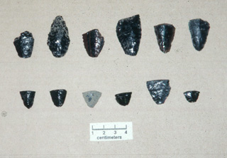
Cultural deposits are stratified in Stratum VI. Increasing cultural materials were encountered in both Cave 5 and 6, beginning in about Level 42 (205 to 210 cm), generally some 25 cm below Stratum V. Projectile points are predominantly Foliate with some fragments of Western Stemmed bases more sporadically represented. Obsidian is the predominant stone tool raw material type. This is the cultural component Bedwell (1970:233) referred to as Unit 2, the 'Transitional' phase, radiocarbon dated between 7000 and 8000 RCYBP. Recent UO excavations have resulted in an additional two radiocarbon dates of 7810±40 RCYBP (Beta-160830) and 7950±40 RCYBP (Beta-146867) for these cultural deposits, which for ease of discussion is referred to as the 'Upper Pre-Mazama Component'.
By Level 50 (245 to 250 cm) fine-grained basalt and/or andesite forms a large portion of the stone tool material type. Projectile point types exhibit greater variety, with more of the long, narrow lanceolate forms like Haskett, Black Rock Concave Base, and Cougar Mountain types which appear in about equal numbers with Foliate projectile points. Points are made of both obsidian and andesite, though obsidian remains the preferred tool stone material. The production of large numbers of oval scrapers made of predominantly of andesite has contributed substantially to the large quantity of andesite present in this component. Bison teeth consistently appear in these deposits though bone has seldom been preserved under the generally moist conditions of this stratum.
This is Bedwell's analytical Unit 3, the 'Western Pluvial Lakes Tradition' (1970:231), for which he accepts radiocarbon dates between 11,000 and 8000 RCYBP. Recent UO excavations have resulted in an additional two radiocarbon dates of 8960±90 RCYBP (Beta-160827) and 9430±80 RCYBP (Beta-160829) for these cultural deposits, which for ease of discussion is referred to as the 'Lower Pre-Mazama Component'.
Stratum VII. StratumVII, the Pleistocene shore line sediment, is culturally sterile and composed of unsorted deposits of well-rounded beach sand, gravel, and cobbles laying on and just above bedrock. The "floury" silts at the bottom of Stratum VI give way to a thin "crusty" sandy gravel, below which are much larger basalt and andesite cobbles. Tiny quantities (<1%) of extremely rounded (water rolled?) and small (<1 cm), buff colored volcanic cinders are included in this gravel. These first appear with rounded beach gravels near the bottom of Stratum VI where they appear to be intrusive from Stratum VII.