
Earth:
The planet which we know the most about, due to our ability to explore its interior as well as exterior, is the Earth Most of this course will compare values and processes on other planets to those on the Earth, i.e. it is our yardstick for understanding other worlds. Therefore, knowing about our home world is crucial to appreciating the Universe, besides being necessary for our own survival.
In many ways, Earth is unique in the solar system. Its most obvious feature is the vast amounts of liquid water on its surface, as well as the ability to sustain intelligent life.
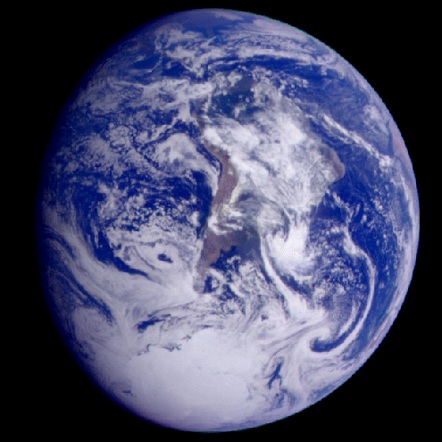
The above color image of the Earth was obtained by the Galileo spacecraft when it was about 1.3 million miles from the planet, displays our world as would be seen by a space probe from another solar system. Galileo was making the first of two Earth flybys on its way to Jupiter. South America is near the center of the picture, and the white, sunlit continent of Antarctica is below. Picturesque weather fronts are visible in the South Atlantic, lower right.

The above is an infrared image of the Earth was taken by the GOES 6 satellite on September 21, 1986. A temperature threshold was used to isolate the clouds. The land and sea were separated and then the clouds, land and sea were separately colored and combined back together to produce this image.
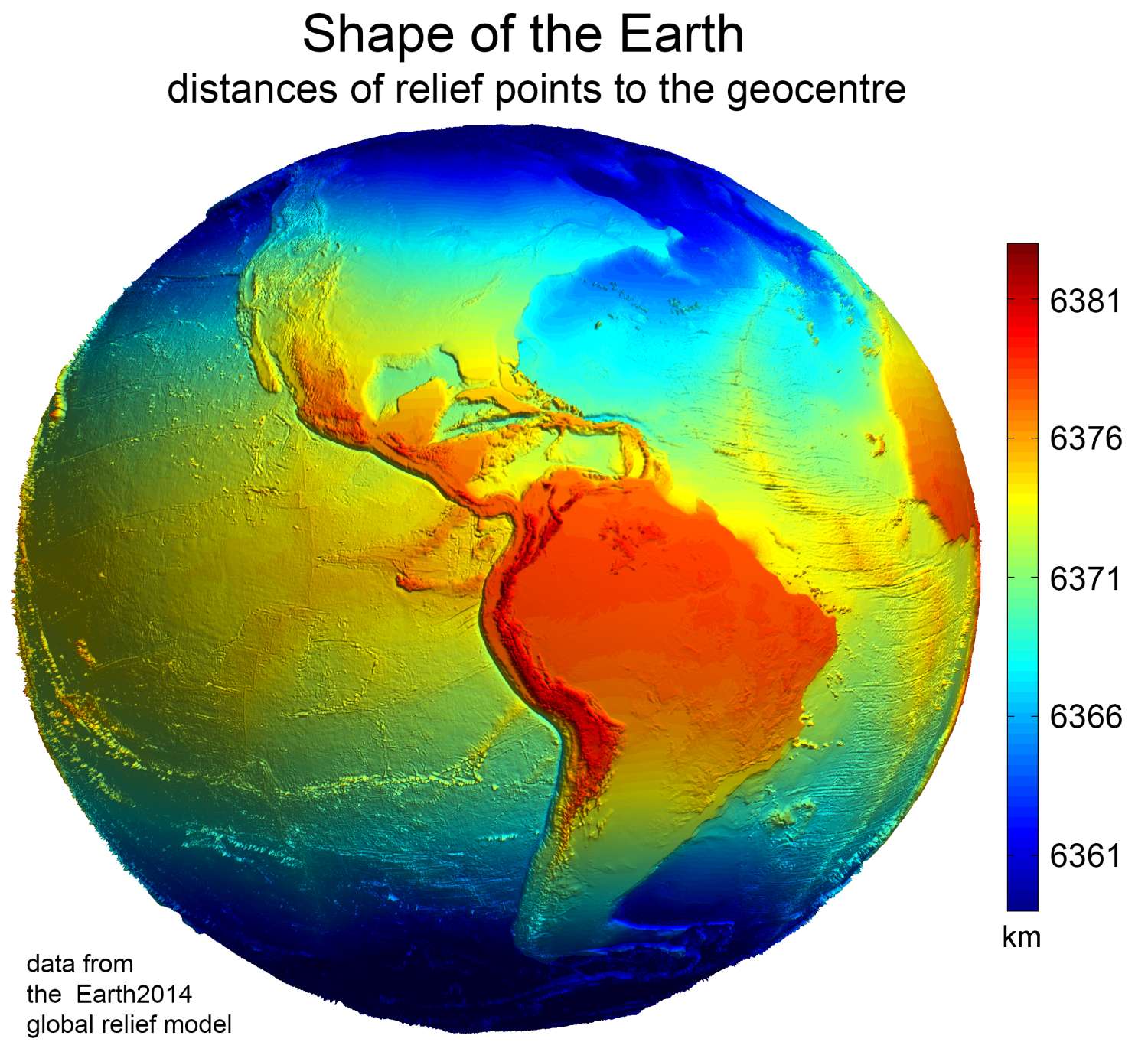
The shape of Earth is approximately oblate spheroidal. Due to rotation, the Earth is flattened along the geographic axis and bulging around the equator. The diameter of the Earth at the equator is 43 kilometres (27 mi) larger than the pole-to-pole diameter. Thus, the point on the surface farthest from Earth's center of mass is the summit of the equatorial Chimborazo volcano in Ecuador. The average diameter of the Earth is 12,742 kilometres (7,918 mi). Local topography deviates from this idealized spheroid, although on a global scale these deviations are small compared to Earth's radius: The maximum deviation of only 0.17% is at the Mariana Trench (10,911 metres (35,797 ft) below local sea level), whereas Mount Everest (8,848 metres (29,029 ft) above local sea level) represents a deviation of 0.14%.
Surface Features:
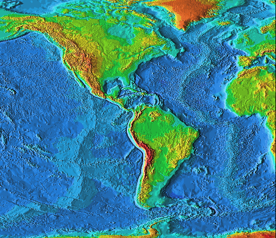
The above image is a map of North and South America using radar altimetry to reflect the underlying topography of the oceans and continents.
The total surface area of the Earth is about 510 million km^2 (197 million sq mi). Of this, 70.8%, or 361.13 million km^2 (139.43 million sq mi), is below sea level and covered by ocean water. Below the ocean's surface are a system of continental shelves, mountains, volcanoes, oceanic trenches, submarine canyons, oceanic plateaus, abyssal plains, and a globe-spanning mid-ocean ridges. The remaining 29.2% (148.94 million km^2, or 57.51 million sq mi) not covered by water has terrain that varies greatly from place to place and consists of mountains, deserts, plains, plateaus, and other landforms. Tectonics and erosion, volcanic eruptions, flooding, weathering, glaciation, the growth of coral reefs, and meteorite impacts are among the processes that constantly reshape the Earth's surface over geological time.
The continental crust consists of lower density material such as the igneous rocks (i.e., granite). Less common is basalt, a denser volcanic rock that is the primary constituent of the ocean floors. Sedimentary rock is formed from the accumulation of sediment that becomes buried and compacted together. Nearly 75% of the continental surfaces are covered by sedimentary rocks, although they form about 5% of the crust. The third form of rock material found on Earth is metamorphic rock (i.e., marble), which is created from the transformation of pre-existing rock types through high pressures, high temperatures, or both. The most abundant silicate minerals on Earth's surface include quartz, feldspars, amphibole, mica, pyroxene and olivine. Common carbonate minerals include calcite (found in limestone) and dolomite.
The elevation of the land surface varies from the low point of -418 m at the Dead Sea, to a maximum altitude of 8,848 m at the top of Mount Everest. The mean height of land above sea level is 840 m.
The pedosphere is the outermost layer of Earth's continental surface and is composed of soil and subject to soil formation processes (i.e., decaying plant material). The total arable land is 10.9% of the land surface, with 1.3% being permanent cropland. Close to 40% of Earth's land surface is used for cropland and pasture.
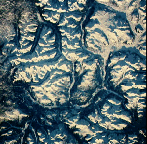
The above image is part of the Rocky Mountain Range in the Yukon Territory of Canada is an excellent example of young mountains on Earth. This space shuttle image was taken when the sun was low on the horizon; the sharp shadows on the snow-covered peaks show how rough and uneven the area is.
The above picture is a space shuttle image of the Colorado River in Arizona captures the Grand Canyon. The canyon is 30 km (18 miles) across at its widest point and 1.6 km (1 mile) deep at rock bottom. It is 446 km (277 miles) long and covers an area that is over 5000 square km (about 2000 square miles). The Grand Canyon was created by the erosional action of the Colorado River on the surface as this region has continued to rise high above sea level over the last several million years.

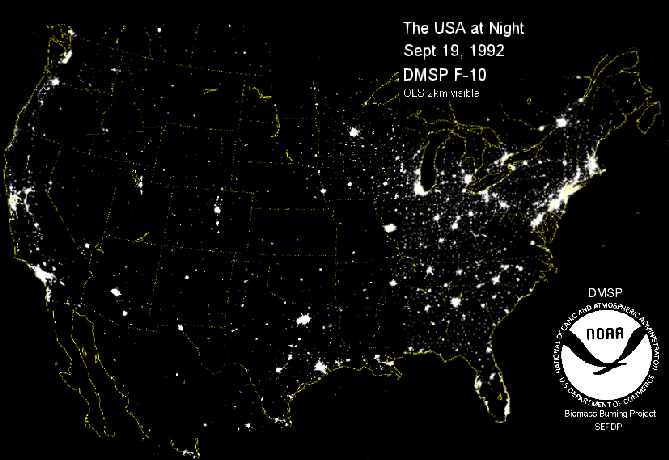
Where do people live? i.e. where are the population centers? The fastest way to check this is to observe the USA at night
Observations:
There are a number of hard facts about the Earth that have been determined over the years of geological surveys:
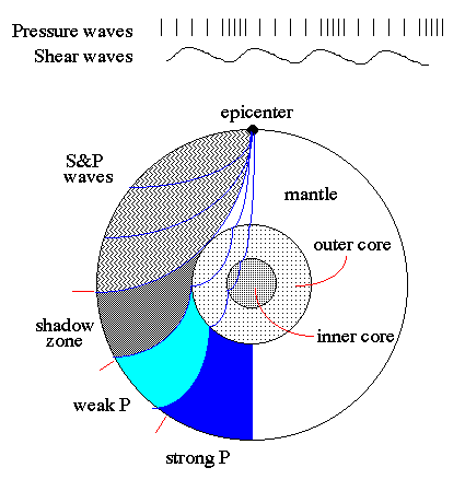
Seismic waves travel at about 10 km/sec and, from mapping of the timing and type of wave around the globe, we are able to map the interior of the Earth. Changes in refraction of seismic waves are due to sharp changes in the density = discontinuities due to chemical composition.
The result is that we know that the interior of the Earth has 4 components:
The temperature of the inner core is 6200 K. The layers of lower density float on top of the the higher density ones, like cork on water. The rocky crust is therefore on the outside.
For example: uranium 238 decays to lead 206 with a half-life of 4.5x10⁹ years. So, if a rock is 1/2 U 238 and 1/2 Pb 206 then its age is 4.5x10⁹ years.
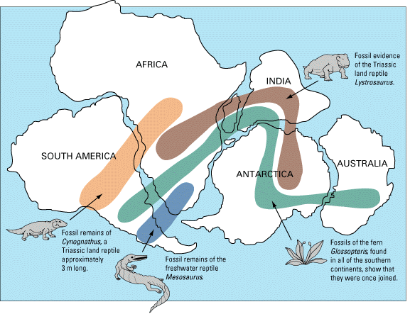
Oldest rocks on the Earth are 3.8x10⁹ years by radioactive dating. The oldest rocks in meteors are 4.7x10⁹ years. Thus, the crust is not original Solar System material. It has been reprocessed by some method (hint: the age of the ocean floor is only 0.2x10⁹ years).
Earth's Crust:
The surface of the Earth is 71% water and 29% land (we should have named our planet Ocean). A typical cross section of the crust looks like the following:
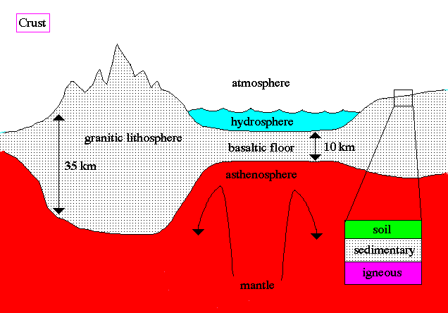
The dry land is composed primarily of:
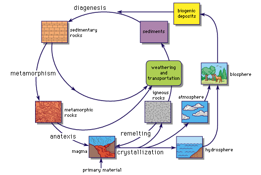
The typical lifecycle of these kinds of rocks is given in the following diagram:
In addition, the crust shaped by the following processes (which will be important for other terrestrial worlds):
1. impact cratering in the early solar system
2. erosion - wind, water, slumping (gravity) - most early cratering erased by erosion on planets with thick atmospheres
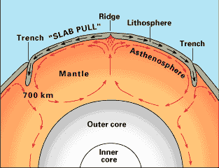
3. thermal-tectonic activity (plate tectonics) - outflow of heat from core transfered to convective motion in mantle.

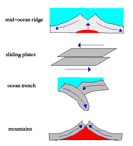
There are four (4) types of boundaries between the plates which give rise to particular surface features. For example, colliding plates form mountains.
Young mountain system are sharp and irregular (e.g. Himalayas), old mountain systems are low and rounded (e.g. Appalachians)
An example of tectonic activity in the form of volanic activity on the Earth = Mt. St. Helens:
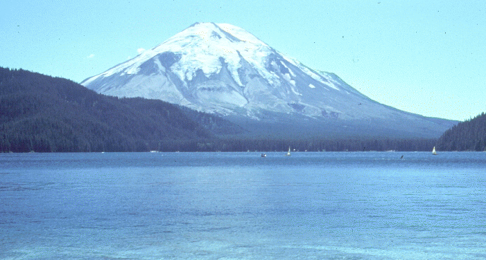
before

after
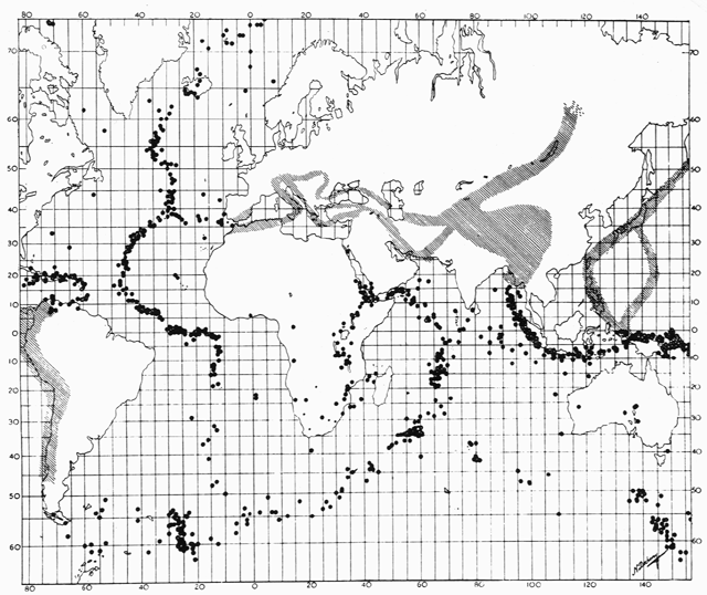
As early as the 1920s, scientists noted that earthquakes are concentrated in very specific narrow zones, now known to be plate edges . In 1954, French seismologist J.P. Roth published this map showing the concentration of earthquakes along the zones indicated by dots and cross-hatched areas. This displays a crude outline of the underlying plate structure.

Earth's Atmosphere:
People have always known that the atmosphere thins and gets colder with higher altitude. During the 1940's and 50's rockets were achieving higher and higher attitudes, compared to mountains, with each test. Thus, the question was raised, where does outer space begin? Answering this question depends upon with whom you are discussing the subject. A doctor would state that outer space begins when the human body can no longer survive in the atmosphere. A propulsion engineer might say that space begins when a jet engine which needs air from the atmosphere to function can no longer operate. An aerodynamic engineer might say that space begins when there is not enough of an atmosphere for an aircraft's control surfaces to operate the craft. A bureaucratic agency might have one definition and an international organization may have another.
Obviously space does not start at the surface of the Earth because that is where our atmosphere pragmatically begins. If we climb to about 3000 meters (m) (10000 feet) we find that the amount of oxygen present and the pressure with which this oxygen enters our bodies is really not enough to keep a human body operating efficiently, although numerous people have adapted to live and work at this level (e.g. LaPaz, Bolivia; Quito, Equador; Katmandu, Nepal). The Federal Aviation Administration has dictated a regulation that whenever pilots fly above 3000 m (10000 feet) they will have supplemental oxygen available for them and their passengers. The United States Air Force goes a little further and states that their pilots will be on oxygen above 10,000 feet cabin pressure altitude. As altitude increases, the need for supplemental oxygen also increases.
| At 5000 m (17000 feet) | One half of the mass of the atmosphere is below this attitude. At this point a pilot who is at this cabin altitude must be on oxygen or a condition known as hypoxia (lack of oxygen to the blood or circulatory system) will render the aviator unconscious within 30 minutes. |
| At 16000 m (16 km or nine miles) | The use of supplemental oxygen fails as a sustainer for human life. At this altitude the combined pressure of carbon dioxide and water vapor in the lungs equals the outside atmospheric pressure and supplemental oxygen alone cannot reach the blood without additional pressure. Therefore, an individual must be in a pressurized cabin or wearing a pressure suit. |
| At 20 km (12 miles) | The outside atmospheric pressure equals the vapor pressure of the human body or about 47 millimeters of mercury. In this environment bubbles of water and other gases begin to form in the body. The bodily fluids begin to literally boil. A pressurized cabin or a pressure suit is a requirement to protect an individual at this altitude from this violent condition. |
| At 24 km (15 miles) | An aircraft's pressurization system no longer functions economically. There is so little oxygen and nitrogen at this altitude that it cannot be compressed to protect the pilot, crew, or passengers from the outside elements. Also at this altitude, the ozone layer begins to form in the atmosphere. Even though ozone consists of three atoms of oxygen per molecule, this substance is poisonous to the human body and compressing ozone would poison the cabin and its occupants. At this altitude the cabin or space suit must have its own pressure and oxygen independent of the outside atmosphere. For the human body space begins at this point because above this altitude a human must carry everything in order for the body to survive. This is probably the medical definition of where space begins. |
| At 32 km (20 miles) | Turbojets can no longer function. Used today as a means of propulsion for all modern jet aircraft, turbojets intake air and compress it by means of fans to mix with fuel for combustion. At 32 km there is not enough air to compress for mixing with the fuel; above this altitude aircraft must use ramjets. A ramjet operates similar to a turbojet except that a ram jet compresses air using supersonic shockwaves rather than fans. The speed of the air going through the shockwave compresses it much more efficiently than the mechanical turbojet. |
| At 45 km (28 miles) | There is not enough air even for a ramjet to operate. Above this altitude a propulsion system needs to provide its own oxygen, also known as oxidizer, as well as fuel, i.e. a rocket. To a propulsion engineer space begins above this altitude. |
| At 81 km (50 miles) | One government agency, the United States Department of Defense says that space begins because it awards all pilots who fly above this altitude astronaut wings. This group not only includes all the people who have flown the space shuttle and various other craft into space, but also the X-15 pilots who flew above this altitude. |
| At 100 km (62 miles) | Aerodynamic forces are no longer effective enough to move the various control surfaces to control an aircraft. The rudder, the aileron, and the elevator are no longer effective because there is not enough atmosphere for either lift or drag the two major aerodynamic forces to be effective. At this altitude the sky is dark; the stars no longer shimmer, but are hard points of light. Other than on-board equipment, there is no sound; no sonic booms, no explosions, or no shockwaves can be heard in space. |
International law states that there is no definitive point where the atmosphere ends and space begins. The major space powers accept the following definition: Space begins at " the lowest perigee attained by orbiting space vehicles...", although this will vary with the size and shape of the vehicle. Perigee is the closest approach point to the Earth in an elliptical orbit. A potential challenge to this definition occurred in 1976 when eight equatorial nations issued declarations of sovereignty over the geosynchronous orbit belt which lies 35862 kilometers above the equator. Columbia, Equador, Brazil, People's Republic of the Congo, Zaire, Kenya, Uganda, and Indonesia also stated that they would defend such areas. But in 1980 the United Nations determined that such claims were null and void because Outer Space is international territory.
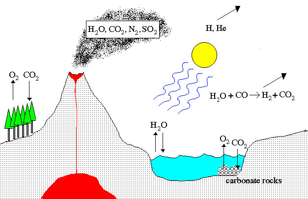
Atmosphere Evolution:
The Earths atmosphere has undergone some extreme changes since the time of its formation. The process has 7 stages:
Although the CO2 content is very small, this trace gas plays an important role in terrestrial climate, in that it is responsible for the greenhouse effect. Atmospheric CO2 traps IR radiation (heat), thereby increasing the surface temperature to levels compatible with the sustainability of life.
The atmosphere also plays an important role in protecting the surface from UV and cosmic rays, and space debris (meteoroids).
Earth's magnetic field:
A field is one of those mathematical conceptual tools to help us understand the behavior of objects with energy. A field assigns to every point in space a strength or force plus direction. A field is used to calculate resulting motion of object within the field and acted on by the field.

The Earth is surrounded by a magnetic field, generated in the core of our planet, in the shape shown below. The field lines (red in diagram below) show different strengths where the lines closest to the Earth are stronger than the lines farther away.
Earth's magnetic field is distorted, compressed on the side facing the Sun, greatly extended on the opposite side. The reason for this is the solar wind, a particle flux from the sun, consisting mostly of protons and electrons.
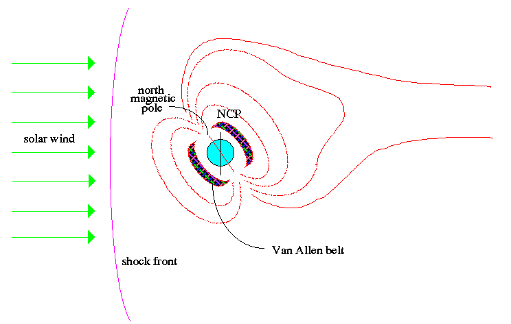
The origin of the Earth's magnetic field is its Iron/Nickel (Fe/Ni) inner core. The inner core is hot and its rotation produces friction which ionizes the Fe/Ni atoms. Ionization means many free electrons in the core. Free flowing electrons = electric current. By the dynamo effect, a changing electric field produces a magnetic field.

|
|

|