Planning Analysis
Basic Methods for Determining Land Needs
Introduction
You can find a copy of the Eagle Point Buildable Lands Study here.
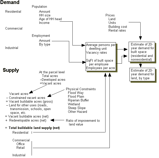
A Land Needs Assessment can be thought of as containing a supply analysis (buildable and redevelopable land by type) and a demand analysis (population and employment growth leading to demand for more built space: residential and non-residential development). Figure 1 shows the key relationships. The geographic scope of the Land Need Assessment is all land inside the Urban Growth Boundary (Oregon), or a predefined study area.
Figure 1: Components of a Land Needs Assessment
Source: ECONorthwest, City of Corvallis Land Needs Analysis, 1998
Supply of Buildable Land, by type
Classifications
There are many ways that "vacant land" and "buildable land" can be defined. We have to pick one. Figure 2 shows an organization that is internally consistent.
Figure 2: Classification scheme for urban land
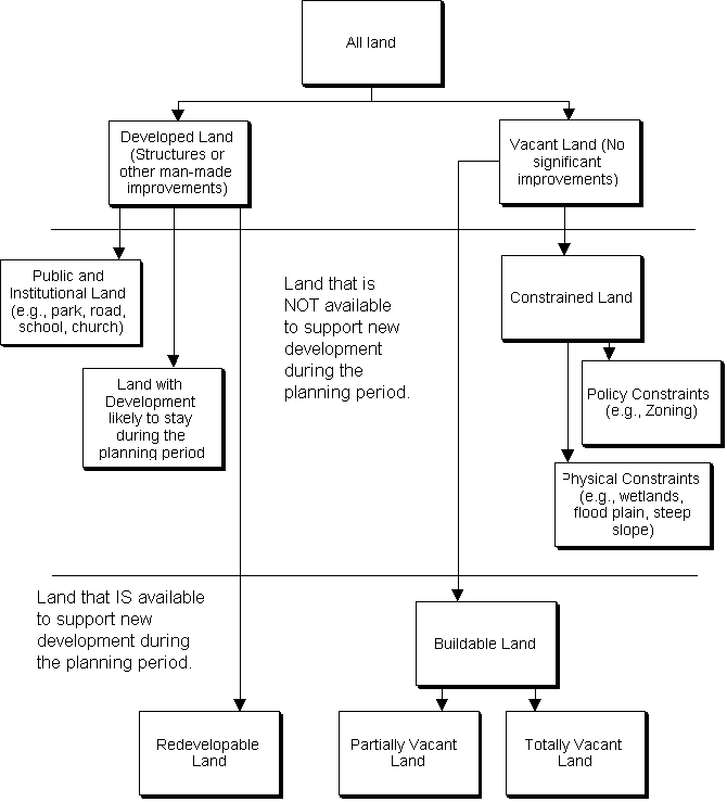
Source: ECONorthwest, City of Corvallis Land Needs Analysis, 1998
Figure 2 illustrates that:
Definitions
Figure 2 gives general definitions of different types of land; those definitions must be more specific, however, about measurement and thresholds. For example, how much vacant land must a developed parcel have to allow the parcel to switch from "developed" status to "partially vacant" status? The details of the definitions follow.
Buildable Lands
According to ORS 197.295,
(1) "Buildable lands" means lands in urban and urbanizable areas that are suitable, available and necessary for residential uses. "Buildable lands" includes both vacant land and developed land likely to be redeveloped.
The above definition applies narrowly to residential land. Most inventories, however, apply a similar definition to all land.
Gross and Net Vacant Acres
Land must be classified into a series of mutually exclusive categories. Most land needs analyses provide a series of definitions. These definitions change depending on the community. The following examples are from the Corvallis analysis.
Each parcel should be assigned to one of the following land use categories:
- Wetlands
- Floodplain
- Drainageways
- Hazardous Land: Slide Areas, Steep Slopes, and Earthquake Faults
- Lands with service constriants
Methods for the land supply analysis
This section summarizes the steps in the land supply analysis. It includes a proposed table structure (for a database or spreadsheet) that facilitates a summary of land supply that can be cross-referenced geographically, by plan designation, and other variables. The general structure is based on the DLCD HB 2709 workbook, which specifically addresses residential lands. We'll use similar methods for commercial, industrial, and other lands.
As outlined in the Workbook, the steps and sub-steps in the supply inventory are:
Here is a general structure for the parcel database that should be generated with GIS overlays. For ease of presentation, the columns of the database (i.e., the fields) are listed below as bullet points (so don’t mistake them as rows of the database; i.e., records). In other words, for each record (which probably means each parcel in the database) we would create the following fields:
K gives net buildable land by type (since ‘A’ is really a multitude of parcel attributes; ‘L’ is one more attribute for reporting redevelopment potential). We can then sort by type and location to report subtotals.
Some of the data (e.g., public facilities) will be based on community-level assumptions and can be calculated in the database. Other data will be the result of GIS output based on layer intersections at the parcel or subparcel level. As long as each parcel has a unique identifier, aggregating from subparcels to parcels is not a problem.
Demand for Buildable Land, by Type
Demand for land is characterized through analysis of national, regional, and local demographic and economic data. For residential uses, population and households drive demand. For the residential sector, for example, information about the characteristics of households is used to identify types of housing that will be affordable to area households. For non-residential uses, employment data is the primary driver of demand for land, and is used to estimate probable absorption rates for commercial and industrial lands.
Demand for residential land
Accepted economic theory, as applied to real estate markets, is quite clear that the amount of housing built and purchased in a market is a function of demand factors (e.g., demand for housing by type, driven by number of households, incomes, preferences, and prices of alternatives), supply factors (e.g., the type and quality of the housing product, and the factors that influence the cost of that product and its substitutes), and prices (of the particular housing product and its substitutes by type, quality, and location). In short, though observed housing absorption results from the interaction of many factors, almost no forecasting models used in Oregon planning work that way. Rather, they forecast demand and supply independently, and rarely have even a qualitative (much less quantitative or modeled) analysis of prices.
Determine Actual Density/Mix of Housing
The first step, determining the actual density/mix of housing is relatively straightforward. A good place to start is with the 1990 Census as a base and use building permits to update the housing inventory by type. This should easily lead to a relatively accurate estimate of the mix of units by type.
The second part of this analysis is to determine the actual density of units over the past 5 years or since the last periodic review, whichever is longer. You'll need data on building permits to develop a 5-year trend. At the very least this analysis should be done by plan designation, zoning is better.
A good place to begin this analysis with a list of subdivision approvals since 1990 and then fill in for other housing types using building permit data. If you can get information on subdivisions that includes the total area, the number of units and the individual parcels, then you can get to some pretty specific numbers on density of single family development by plan designation and zone. The multi-family and other types will use a similar approach.
Conduct Housing Needs Assessment
The basic steps listed in the HB 2709 Workbook include:
The Steps in Detail
The steps, as outlined in the Workbook, provide the general structure for a housing demand analysis, but do not provide detail on data sources and approaches. I've reviewed the steps and taken a closer look at what data might be available.
Project the number of new housing units needed in the next 20 years.
This is a basic model that relies on population projections, household size trends, vacancy rates, and persons in group quarters. This seems basic—we'll want to use whatever the coordinated forecast is, with whatever qualifications are necessary.
Identify relevant national, state, and local demographic and economic trends and factors that will affect the 20-year projection of structure type mix.
This is the standard broad to narrow structure we normally begin our discussion of demand factors with. Specifically this section would review:
- Population/Employment trends
We could supplement traditional data with data from Claritas or Max or another vendor. I used Claratis data for the Monmouth study—they charge about $60 for basic population/demographic/income reports. I've got some examples if you want to look them over.
One thing that will be hard to get at from the data will be the issue of households that have one or more member working in Corvallis, but choose (or are forced) to live elsewhere for various reasons. We may want to gather some information from HP, OSU and other large employers.
- Household characteristics
- Income
- Housing characteristics
You can use data from the Census, but you can also obtain tax assessment data that may have fairly detailed information in it. County assessors usually have information on on number of units, housing type, condition, value, and sales.
- Housing Market Trends
The housing market trends would rely on a combination of historic data (housing by mix), local interviews, and review of trade publications such as Professional Builder which includes an analysis of national and regional home markets in its monthly publication.
The big issue here is getting current information—particularly on the income/value/age relationship.
PUMS (Public Use Microdata Samples from the Census) data can be used for MSAs and larger jurisdictions. You'll need to have a good working knowledge of Census data and a decent statistical package such as SPSS.
Many states also do population surveys, although the data are generally not statistically valid for smaller communities. The Oregon Population Survey conducted by the Progress Board has relatively detailed data that is useful for a variety of analytical purposes.
Describe demographic characteristics of the population and, if possible, household trends that relate to demand for different types of housing (e.g., household income, household size, age of household head, percent of income paid for housing and tenure).
Again, this step should be completed before allocating needed housing by type. This would rely on the data from step 2 (PUMS, Oregon Population Survey) to determine the relationships.Basic trend analysis of Census data is also useful.
Determine the types of housing that are likely to be affordable to the projected households, based on household income, household size, age of household head, tenure data and trends, and knowledge about national, state, and location housing trends, and local housing policies.
This step is primarily a manipulation of data, combined with local interviews. At this step, the data need to be analyzed to compare income and affordable housing value and compare that with housing values in the community being analyzed.
Estimate the number of additional needed units by structure type.
The key variables here are:
- Household size
- Age of household head
Based on these trends and other data, we need to allocate housing need by type of structure.
Determine the needed density ranges for each plan designation and the average needed net density for all structure types.
The workbook suggests looking at the relationship between lot size, year built and living area to determine trends over time. The A&T data should contain these three variables. The second issue to address is the effect of land price, availability and location on these trends. You'll have to look at the supply data to make this connection. The final step is to allocate housing and determine needed acres based on a range of densities.
Demand for commercial and industrial land
Depending on the policy context within which such a land analysis is conducted, its requirements can be more or less rigorous. At one extreme, such an analysis might be part of a developer’s market analysis or a zone. In those cases, the format and rigor of the analysis is not specified in detail. At the other extreme, such an analysis might be part of a UGB amendment or a Goal 9 analysis, in which case several requirements regarding content and methods would have to be met.
Several methods exist to determine industrial land need. The method most appropriate depends on the data available. Basic methods such as extrapolation of past development trends or ratios of industrial acres per employee or per total land area are appropriate for small communities where data are limited. These methods, however, only forecast land demand in the aggregate: they cannot provide reliable estimates by sector or type.
For larger communities that have better data sources, forecasting industrial land need is usually based on ratios of employee per land area (acre). This is the method that the Lane Council of Governments (LCOG) applied in the 1993 Metropolitan Industrial Lands Inventory Report. Because this inventory is the acknowledged Goal 9 industrial lands inventory for the Eugene-Springfield Metropolitan Area.
Determining non-residential land need involves both a demand component and a supply component. Figure 1 illustrates how we evaluated those components in this project.
Figure 1: Determining non-residential land need
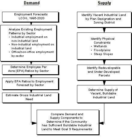
Non-residential land demand
The basic steps in the approach shown above are:
[Home | Syllabus | Schedule | Assignments | Project | Links]
This page maintained by Bob Parker,
©2002
October 21, 2003