Survey Methods
The ELP Turtle Team is charged with collecting the first round of survey information on potential Western Pond Turtle habitat for the Bureau of Land Management. This survey information will be used in future projects to determine where potential restoration projects will take place. BLM land in the greater Eugene area with habitat potential was broken down into separate areas, called polygons, and given an importance rating of red, green, and blue corresponding to high, medium, or low priority. With around 30 total polygons of various sizes to survey, this gives the team a way to hit areas with the greatest potential for turtle habitat first. The team splits up into smaller survey groups, gets their list of polygons for the week, and goes to work.
After using BLM road maps and aerial photos to map a route to the polygon, the survey team starts their stream walk with a variety of tools in hand and guidelines in mind. Staying within sight of the creek, the team must think like a turtle, looking for potential habitat in the form of slow moving deep water. Habitat can be found in stream channels as the water slows down after a sharp corner, or in a pond or pool structure close to the river. Habitat can come in a varietuy of shapes and sizes so there are certain guidelines that have been set to assist in locating habitat. The water must be moving slowly, and it must be deep enough for turtles to submerge and hide. Basking structures such as rocks or logs and some aquatic vegetation is also desirable. Once a habitat feature is located, a dataset is recorded.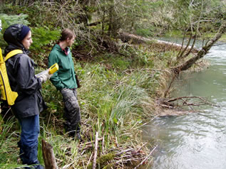
The collected data represents important information about turtle habitat used by the BLM, It is recorded both digitally using a Trimble GPS receiver and data recorder, and traditionally using pencil and paper. The data that is recorded contains:
-
UTM Coordinates
-
Township, Range, and Section
-
Length, Width, and Depth
-
Bank Slopes
-
Air Temperature and Cloud cover
-
Percent Canopy cover
-
Presence of Basking Structure
-
Number of Turtles Present
-
Distance From the Road
- Additional Comments
Using aerial photos and onsight judgement the team decides whether to do a nesting habitat search. Turtle turtle nesting area tends to be found in grassing meadow areas within 500 meters of the stream. If nesting habitat is found, another data entry is made to record information about it including:
A hand drawn schematic is also recorded to give the BLM and idea of the size and shape of the potential nesting habitat.
Both the digitally recorded and hand recorded data is than collected and sent off to the Eugene BLM office once a week for entry into their database. When completed the project will have mapped much of the area around Eugene, and the BLM can move into the next possible phase of habitat restoration or continued surveying.
