Northern Great Basin Prehistory Project
Archaeological Field School
2018 Summer Session
Rimrock Draw Rockshelter (35HA3855): A Summary of Recent Fieldwork at a Stemmed Point Site Near Riley Oregon
by Kelsey Provost, Jessica French, and Pat O'Grady
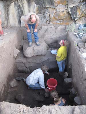
Rimrock Draw Rockshelter is located near Riley Oregon in Harney County. During the period from September 12 to September 23 of 2011, test excavations occurred at the site to determine its potential for use as a field school research project. This paper is a summary of the recent fieldwork, some artifacts that were found, and plans for future research at the location.
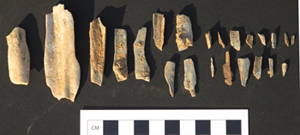
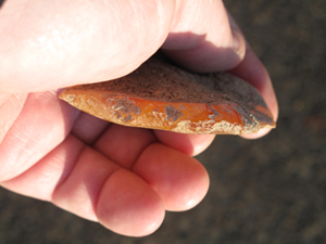
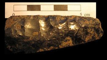
Discovered during surveys by the Burns Bureau of Land Management and volunteers from the Oregon Archaeological Society, the surface finds included 26 stemmed points, a Black Rock Concave Base point, a crescent fragment, Northern Side-Notched points, biface fragments, including a fluted biface, overshot flakes suggestive of Clovis technology, a small number of Elko Series points, and a bedrock mortar. The stemmed points are, by far, the dominant group of projectile points recovered on the surface and they account for all of the diagnostic artifacts collected within the excavation units that are described in greater detail below. Most have rounded bases, but six have squared bases and the majority are representative of Parman Type 1 and Parman Type 2 points, respectively. The fluted biface, in association with the overshot flakes, is of particular interest because, through proximity, they point to the possibility that Clovis-age artifacts might be deposited within the rockshelter itself. Crescents are unique and somewhat enigmatic stone tools that are more frequently found in lakeside settings, so the recovery of a fragment along the stream drainage was surprising. Black Rock Concave Base points are uncommon anywhere in Oregon, but the 10,000 - 12,000 year old points are found more commonly in the area around Riley and Wagontire than elsewhere. All of the surface-collected artifacts were found within a 300 meter radius of the rockshelter.
Encouraged by the finds and noting 6 to 7 feet high sagebrush around the rockshelter apron which is an indicator of deep sediments, Burns BLM Archaeologist Scott Thomas recommended the use of an auger in front of the rockshelter. The auger pulled up an obsidian flake at 180 cm, and reached 200 cm before bottoming out on rock. Thomas decided to promote the excavation at the rockshelter as a means of exploring early Holocene climate change, and funding for the project was approved by the BLM state and national offices.
A crew composed of BLM and U of O archaeologists put in two 2x2 and one 1x1 test units at the site to assess the potential for understanding climate change issues, and with the hope the site could eventually become a University of Oregon field school location. The excavations revealed the presence of two cultural components, including an upper component furnished with a hearth and ground stone implements, and a dark, midden-like lower component that terminated in a compacted occupation surface at 180 cm.
The stratigraphy in Units 1 and 2 indicated water borne silt to coarse sands. The sediments also indicate gradual accumulations over time, consistent with the idea that the small drainage that passes the site today was once perennial.
Unit 1 was located against the rockshelter face. Excavations in Unit 1 ended at 200 cmbd with only a small exposure of sediment at that point. The sediments became extremely dark and rich in charcoal at level seven. A hearth feature was identified in the sidewall, on top of the bedrock that eventually encompassed the majority of the unit. The hearth feature contains two charcoal lenses interbedded with fire affected earth. Obsidian flakes are present in the sidewall in both the charcoal lenses and the fire affected earth. After excavating the feature, sediment samples were taken from both charcoal lenses. Large amounts of charcoal were recovered throughout Unit 1 in level 7. The hearth feature ties in well with an upper cultural component that was equally prominent in Unit 2 just north of Unit 1. There, a mano and a metate were found in levels 5 and 7 along with an abundance of lithic debitage. Pollen analysis is pending on the ground stone.
Auger probes were put in across the site in order to obtain a better sense of the sediments. At about one meter, Auger Probe 2, located northwest of Unit 2, pulled up extremely black sediment, much darker than the previous. The auger work served as a guide to what might be found in the excavation units. The same sediment appeared in Unit 2 at the same depth and was determined to be a distinct cultural component due to the high quantities of artifacts found within. This lower cultural component, distinct from the upper component with the hearth and groundstone, is approximately 50cm thick, made up of loosely consolidated silt, charcoal, and other cultural material. The lower cultural component transitions into a thin, well compacted and discrete occupation surface that displays a clear change from the previous sediments. The occupation surface sloped in a dish shape to the southeast, towards the back of the shelter. Underlying this surface at an abrupt transition is an orange to medium brown sand and gravel layer, in which artifact counts are sharply reduced. The orange layer may prove to be sterile with depth, but our time was too limited to explore this deposit beyond the initial discovery.
The lower component represents a distinct cultural deposit for several reasons. First, the dark color and texture are consistent with other Great Basin examples of concentrated habitation. Second, already consistently high counts of debitage increased within the cultural component, especially at level 12. Third, fifteen tools were collected throughout, including bifaces, scrapers, EMFs, and ground stone. On the deep occupation surface, a cache of debitage was found at 170-180 cmbd in Quad A. The cache was 25 cm x 13 cm in size at 170 cmbd. It was located on a narrow rock ledge that suggested site furniture. The cache consisted of 88 obsidian flakes, an obsidian scraper, and a biface with overshot flakes removed from it. Also found on the occupation surface was a stemmed point preform with weak shoulders, near a ground stone artifact of indeterminate use.
Early in the project, it was decided that a third unit would be opened 10 meters to the west of TU-1 and 2 in a smaller alcove of the rockshelter. Tools were recovered in levels 4-7. They included a scraper, two hammer stones, and a chopper. A stemmed point with an intact base and resharpened blade was recovered from level 2. The unit was so rocky that it was not possible to delineate any cultural components beyond the tool concentration.
Built up against the wall of the rockshelter between Units 1/2 and Unit 3 is a packrat midden that holds the potential for producing perishable cultural material. To illustrate, a pair of feathers bound with sinew were found on the ground surface below the midden after a strong windstorm passed through. Attempts to date the feathers will be made following species identification. Their existence is a positive sign that the packrat midden could hold more artifacts. Future plans includes disassembly of the midden in hopes of finding more perishable material.
The test excavations at Rimrock Draw Rockshelter were extremely successful in demonstrating how important this site could be to Northern Great Basin Archaeology. There is solid evidence for extended habitation of considerable antiquity that carried across two weeks of excavation. Cultural deposits extended to 2 meters and auger probes indicated at least another 50 cm of untested sediments lie below.
At this stage, artifacts are being submitted for analyses of various kinds. The buried lithic tools will be sent for protein residue analysis, and then forwarded for obsidian sourcing and hydration. The ground stone objects will be sent for pollen and macrobotanical analysis. Charcoal from the hearth and from in situ recovery is being identified in preparation for radiocarbon dating, and the feather bundle will be sent away for identification and eventual dating. The University of Oregon plans on running an archaeology field school at the Rimrock Draw Rockshelter beginning next June. A paleobotany field school will also run for three weeks and offer four credits of instruction. The abundance of cultural material makes Rimrock Draw Rockshelter an exciting new site with great potential for multiple lines of research.
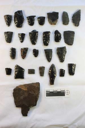
Items recovered from the 2012 excavations at Rimrock Draw Rockshelter:
