|
The Regional Setting of the Galapagos Archipelago Regional Earthquake Epicenters of the Galapagos Archipelago 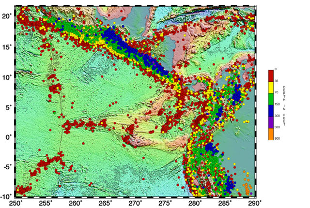 | | Bathymetric and topographic data compiled by: Smith, W. H. F. and D. T. Sandwell, Global Seafloor Topography from Satellite Altimetry and Ship Depth Soundings, Science, v. 277, p. 1956-1962, 26 September, 1997. Earthquake (PDE) data retrieved from: http://www.neic.cr.usgs.gov/neis/epic/epic_global.html |
Deep trenches at plate boundaries mark subduction zones. The Peru-Chili Trench is located east of the Galapagos Islands at the Nazca and South American plate boundary. The Mexico Trench is located north of the Galapagos Islands at the Cocos and Caribbean plate boundary. Tectonic plate motion is responsible for most of the seismic activity in the region. Earthquakes are driven by stresses inside the earth. Earthquakes are located at boundaries between the tectonic plates. The "great earthquakes" (magnitude 8 or higher) usually occur at subduction zones. Since the oceanic plate does not subduct smoothly under the continental plate (rather, it sticks), over time stress builds up and is suddenly released causing a large earthquake. Subduction zone earthquakes, like those along the Mexico and Peru-Chili Trench, typically produce ground shaking that lasts for over a minute or two and have many aftershocks. Since the Mexico and Peru-Chili Trench are located just offshore, when an earthquake occurs damaging tsunamis may follow. Because subduction zones mark the area where one tectonic plate moves beneath another earthquakes can occur at deep, as well as, shallow depths. Earthquakes at spreading centers and transform faults are of smaller magnitude and occur at shallower depths. Transform faults offset spreading centers. A major transform fault is located just north of the Galapagos at 91°W.
|